Best of East Midlands
The 20 best museums in East Midlands
Our curated top 20 museums in East Midlands, ranked by quality rating, image richness and content depth. For the complete list of 506 museums see the full museums index for East Midlands.
- 1
Cromford Mill
Derbyshire

Cromford Mill is the world's first water-powered cotton spinning mill, developed by Richard Arkwright in 1771 in Cromford, Derbyshire, England. The mill structure is classified as a Grade I listed bui
- 2
Strutt's North Mill
Derbyshire
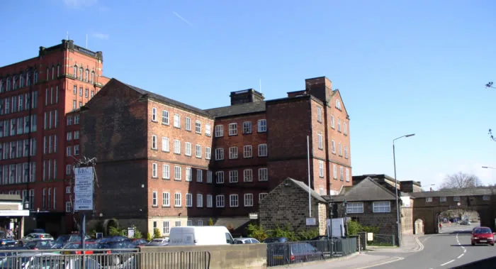
Belper North Mill, also known as Strutt's North Mill in Belper, is one of the Derwent Valley Mills, given UNESCO World Heritage Status in 2001. The mill is sited in Belper, a town in Derbyshire, Engla
- 3
Carnfield Hall
Derbyshire

Carnfield Hall is a privately owned country house located at South Normanton, near Alfreton in Derbyshire, England. It is a Grade II* listed building. The estate includes around ninety acres of par
- 4
Heage
Derbyshire

Heage is a village and former civil parish, now in the parish of Ripley, in the Amber Valley district, in the county of Derbyshire, England. It is situated midway between Belper and Ripley. The villag
- 5
Gosberton
Lincolnshire

Gosberton is a village and civil parish in the South Holland district of Lincolnshire, England. It is situated 9 miles (14.5 km) south-west of Boston, 6 miles (10 km) north of Spalding and 9 miles (14
- 6
Renishaw, Derbyshire
Derbyshire

Renishaw is a village in the district of North East Derbyshire in England. It is in the civil parish of Eckington. Renishaw lies on the A6135 road between the villages of Eckington and Barlborough. To
- 7
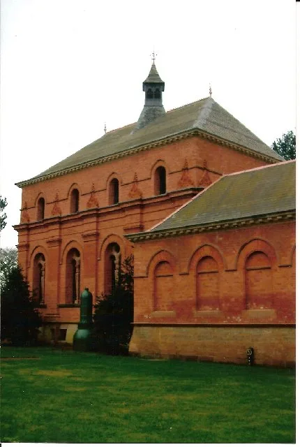
Claymills Pumping Station
Staffordshire

Claymills Pumping Station is a restored Victorian sewage pumping station on the north side of Burton upon Trent, Staffordshire, England DE13 0DA. It was designed by James Mansergh and used to pump se
- 8
River Alport
Derbyshire

The River Alport flows for 5.6 miles (9 km) in the Dark Peak of the Peak District in Derbyshire, England. Its source is on Bleaklow, 3 miles (4.8 km) east of Glossop, from which it flows south throug
- 9
Calverton, Nottinghamshire
Nottinghamshire

Calverton () is a village and civil parish in Nottinghamshire, England and of some 4,247 acres (6.636 sq mi; 1,719 ha; 17.19 km2) in size. It is in the Gedling district, about 7 miles (11 km) north-ea
- 10
River Erewash
Nottinghamshire

The River Erewash is a river in England, a tributary of the River Trent that flows roughly southwards through Derbyshire and Nottinghamshire, forming the boundary between the two counties for much of
- 11
City of Sheffield

The City of Sheffield is a metropolitan borough with city status in South Yorkshire, England. The metropolitan borough includes the administrative centre of Sheffield, the town of Stocksbridge and the
- 12
High Peak, Derbyshire
Derbyshire

High Peak is a local government district with borough status in Derbyshire, England, covering a high moorland plateau in the Dark Peak area of the Peak District National Park. The district stretches f
- 13
Dorrington, Lincolnshire
Lincolnshire

Dorrington is a village and civil parish in the North Kesteven district of Lincolnshire, England. It is situated 1.2 miles (2 km) both south from Digby and north from Ruskington. It is to the east of
- 14
East Midlands Airport
Leicestershire

East Midlands Airport (IATA: EMA, ICAO: EGNX) is an international airport in Castle Donington, Leicestershire, England. The airport is situated between Loughborough (10 miles (16 km)), Derby (12.5 mil
- 15
Papplewick Pumping Station
Nottinghamshire
Papplewick Pumping Station, situated in open agricultural land approximately 3 miles (4.8 km) by road from the Nottinghamshire village of Papplewick, was built by Nottingham Corporation Water Departme
- 16
Cromwell, Nottinghamshire
Nottinghamshire

Cromwell is a village and civil parish in Nottinghamshire, England. It is located 5 miles (8 km) north of Newark. According to the 2001 census it had a population of 188, increasing to 232 at the 2011
- 17
River Ashop
Derbyshire

The River Ashop is a river in the Derbyshire Peak District, England. Its source is on the eastern slopes of Mill Hill, three miles south east of Glossop and just north of Kinder Scout. The river flows
- 18
Burton upon Trent
Staffordshire

Burton upon Trent, also known as Burton-on-Trent or simply Burton, is a market town in the borough of East Staffordshire in the county of Staffordshire, England, close to the border with Derbyshire. A
- 19
Doe Lea
Derbyshire

Doe Lea is a small, linear village in the English county of Derbyshire. It is in the Bolsover district of the county and falls in the Ault Hucknall civil parish. The village runs along the old A617
- 20
East Kirkby
Lincolnshire

East Kirkby is a village and civil parish in the East Lindsey district of Lincolnshire, England. It is situated 7 miles (11 km) south-east from Horncastle, and on the A155 road. East Kirkby 13th centu