
Museums · East Midlands
Calverton, Nottinghamshire
In or near Oxton.
Calverton () is a village and civil parish in Nottinghamshire, England and of some 4,247 acres (6.636 sq mi; 1,719 ha; 17.19 km2) in size. It is in the Gedling district, about 7 miles (11 km) north-ea

Alan Murray-Rust — CC BY-SA 2.0 via Wikimedia Commons licence

Plan your visit
- Typical visit
- 1.5 h–3 h
- Best time of year
- Year-round
- Nearest railway station
- Burton Joyce · 6.6 km
- Free entry
- Family-friendly
- Limited wheelchair access
Getting there & planning your visit
To visit Calverton in Nottinghamshire, the nearest railway station is Burton Joyce, which is 6.6 km away. The postcode for sat-nav is NG14 6HJ. Accessibility is limited for wheelchair users.
About
Calverton () is a village and civil parish in Nottinghamshire, England and of some 4,247 acres (6.636 sq mi; 1,719 ha; 17.19 km2) in size. It is in the Gedling district, about 7 miles (11 km) north-east of Nottingham, 10 miles (16 km) south-east of Mansfield, and situated, like nearby Woodborough and Lambley, on one of the small tributaries of the Dover Beck. The 2021 census found 7,282 inhabitants in 3,120 households. About 2 miles (3.2 km) miles to the north of the village is the site of the supposed deserted settlement of Salterford. The parish is bounded on the south-east by Woodborough, to the south-west by Arnold, Papplewick and Ravenshead, to the north by Blidworth, and to the north-east by Oxton and Epperstone. During most of its existence Calverton was a forest village, in that part of Sherwood known as Thorney Wood Chase, with a rural economy limited by a lack of grazing land, in which handicrafts (like woodworking and the knitting of stockings), must in consequence have assumed a more than usual importance. The parliamentary enclosure of 1780 brought some agrarian progress to the village, but it was not until the opening of a colliery by the National Coal Board in 1952, that the village began to assume its present identity, with new housing estates and marked population growth. The colliery closed in 1999 and while a small industrial estate provides some local employment, Calverton has taken on the character of a large commuter village. In May 1974 the village was
Photo gallery
Official information
Calverton Parish Council manages local services and provides information about community resources such as allotments, cemeteries, and public rights of way. The council holds monthly meetings that are open to the public, fostering community engagement.
From the Wikipedia article
Calverton () is a village and civil parish in Nottinghamshire, England and of some 4,247 acres (6.636 sq mi; 1,719 ha; 17.19 km2) in size. It is in the Gedling district, about 7 miles (11 km) north-east of Nottingham, 10 miles (16 km) south-east of Mansfield, and situated, like nearby Woodborough and Lambley, on one of the small tributaries of the Dover Beck. The 2021 census found 7,282 inhabitants in 3,120 households. About 2 miles (3.2 km) miles to the north of the village is the site of the supposed deserted settlement of Salterford. The parish is bounded on the south-east by Woodborough, to the south-west by Arnold, Papplewick and Ravenshead, to the north by Blidworth, and to the north-east by Oxton and Epperstone. During most of its existence Calverton was a forest village, in that part of Sherwood known as Thorney Wood Chase, with a rural economy limited by a lack of grazing land, in which handicrafts (like woodworking and the knitting of stockings), must in consequence have assumed a more than usual importance. The parliamentary enclosure of 1780 brought some agrarian progress to the village, but it was not until the opening of a colliery by the National Coal Board in 1952, that the village began to assume its present identity, with new housing estates and marked population growth. The colliery closed in 1999 and while a small industrial estate provides some local employment, Calverton has taken on the character of a large commuter village. In May 1974 the village was officially twinned with Longué-Jumelles, in the Loire valley of France.
Excerpt from Wikipedia under CC BY-SA 4.0. See the source article linked in Sources below.
Background
Description
{| class="wikitable" style="text-align: center; width: 200px; height: 200px; float: right" |+ Table to show the population of the parish in the nineteenth century, from the decennial census: |- ! Year ! Population |- | 1801 | 636 |- | 1811 | 904 |- | 1821 | 1064 |- | 1831 | 1196 |- | 1841 | 1339 |- | 1851 | 1427 |- | 1861 | 1372 |- | 1871 | 1319 |- | 1881 | 1246 |- | 1891 | 1199 |- | 1901 | 1159 |- |} Although the village is estimated to have had about two hundred knitting frames at the beginning of the 19th century, it seems to have escaped the worst of the local Luddite disturbances of 1811–12. Because the Luddite rioters only broke the frames of those owners that had lowered men's wages,…
Sourced from Wikipedia under CC BY-SA 4.0.
- Coordinates
- 53.0370, -1.0830
- County
- Nottinghamshire
- District
- Gedling
- Parish
- Calverton
- Postcode
- NG14 6HJ
- Parliamentary constituency
- Sherwood Forest
- Nearest railway station
- Burton Joyce — 6.6 km
- Official site
- www.calvertonparishcouncil.gov.uk
Sources
- wikipedia: Calverton, Nottinghamshire (CC BY-SA 4.0)
Other places nearby
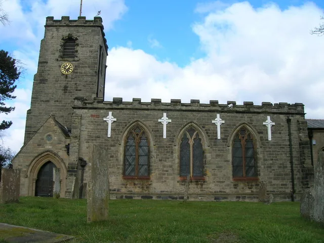
St Wilfrid's Church, Calverton
Historic churches · 0.2 km

Calverton War Memorial
Memorials & monuments · 0.4 km

Fox Wood earthworks
Vineyards · 0.9 km

Sherbrooke Scout Camp
Campsites · 1.3 km

Calverton Colliery
Memorials & monuments · 1.4 km

Cockpit Hill, Ramsdale Park
Vineyards · 2.0 km

Crew Yard Gallery
Galleries · 2.0 km
Farmhouse Gallery
Galleries · 2.0 km
Barn Gallery
Galleries · 2.1 km
Ramsdale Hill
Mountains & hills · 2.1 km

Woodborough
Villages · 2.2 km
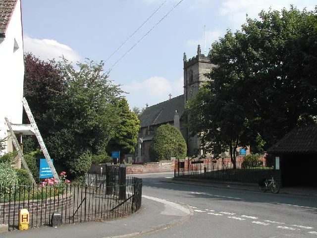
St Swithun's Church, Woodborough
Historic churches · 2.2 km
Nearby
📷 3Historic churches · East Midlands
St Wilfrid's Church, Calverton
St Wilfrid's Church, Calverton — church in Calverton, Gedling, Nottinghamshire, England, UK.
📷 3Memorials & monuments · East Midlands
Calverton War Memorial
Calverton War Memorial — Grade II listed building-listed memorial in england-east-midlands, United Kingdom.
📷 5Vineyards · East Midlands
Fox Wood earthworks
Fox Wood earthworks — a UK vineyard in england east midlands, producing English or Welsh wine from cool-climate grape varieties.
📷 5Campsites · East Midlands
Sherbrooke Scout Camp
Sherbrooke Scout Camp — a campsite in england east midlands.
📷 3Memorials & monuments · East Midlands
Calverton Colliery
Calverton Colliery — a memorial in england-east-midlands, United Kingdom.
📷 5Vineyards · East Midlands
Cockpit Hill, Ramsdale Park
Cockpit Hill, Ramsdale Park — a UK vineyard in england east midlands, producing English or Welsh wine from cool-climate grape varieties.
Where to eat & stay near Calverton, Nottinghamshire
Places to stay
📷 5Campsites · East Midlands
Sherbrooke Scout Camp
Sherbrooke Scout Camp — a campsite in england east midlands.
 📷 5
📷 5Hotels · East Midlands
Bestwood Lodge Hotel
Bestwood Lodge Hotel — a hotel in england east midlands.
 📷 5
📷 5 📷 5
📷 5Campsites · East Midlands
Fairview Farm Holiday Accomodation
Fairview Farm Holiday Accomodation — a campsite in england east midlands.
 📷 5
📷 5Campsites · East Midlands
Lurcher Farm Cottage Camping & Caravanning Site
Lurcher Farm Cottage Camping & Caravanning Site — a campsite in england east midlands.
 📷 5
📷 5Campsites · East Midlands
Notts Sun Club
Notts Sun Club — a campsite in england east midlands.
Places to eat & drink
 📷 7
📷 7Historic pubs · East Midlands
The Five Ways Public House
The Five Ways Public House in England East Midlands, United Kingdom.
 📷 7
📷 7Cafés · East Midlands
Mortons Farm Tea Rooms
Mortons Farm Tea Rooms — a café in england east midlands.
 📷 5
📷 5Restaurants · East Midlands
Turquoise
Turquoise — a restaurant in england east midlands.
 📷 7
📷 7 📷 5
📷 5Historic pubs · East Midlands
Old Pear Tree Public House And Attached Garden Wall
Old Pear Tree Public House And Attached Garden Wall in England East Midlands, United Kingdom.
 📷 7
📷 7Historic pubs · East Midlands
Golden Fleece Public House
Golden Fleece Public House in England East Midlands, United Kingdom.
More museums in this region
 📷 5
📷 5Museums · East Midlands
Stamford Town Hall
Stamford Town Hall — building in Stamford, Lincolnshire, England, UK.
 📷 5
📷 5Museums · East Midlands
Thorney Museum
Thorney Museum — a museum in england-london, United Kingdom.
 📷 5
📷 5Museums · East Midlands
Octavia Hill Birthplace Museum
Octavia Hill Birthplace Museum — a museum in england-london, United Kingdom.
 📷 5
📷 5Museums · East Midlands
Museum of Technology
Museum of Technology — a museum in england-london, United Kingdom.
Frequently asked questions
- Where is Calverton, Nottinghamshire?
- Calverton, Nottinghamshire is in Nottinghamshire, the East Midlands, United Kingdom (postcode NG14 6HJ), in the parish of Calverton.
- What is Calverton, Nottinghamshire?
- Calverton () is a village and civil parish in Nottinghamshire, England and of some 4,247 acres (6.636 sq mi; 1,719 ha; 17.19 km2) in size. It is in the Gedling district, about 7 miles (11 km) north-ea
- How do I get to Calverton, Nottinghamshire?
- The nearest railway station is Burton Joyce, about 6.6 km away. The nearest town is Oxton. Drivers can use postcode NG14 6HJ.
- Is Calverton, Nottinghamshire free to visit?
- Yes, Calverton, Nottinghamshire is free to enter.
- How do I get to Calverton, Nottinghamshire?
- The nearest railway station is Burton Joyce, about 6.6 km away. Drivers can navigate to postcode NG14 6HJ.