Mountains & hills · East Midlands
Peakshole Water
In or near Edale.
Peakshole Water is a stream in the Derbyshire Peak District of England, named after its source, Peak Cavern. It flows through the village of Castleton to join the River Noe in nearby Hope. Despite its

Stephen McKay — CC BY-SA 2.0 via Wikimedia Commons licence
Plan your visit
- Typical visit
- 3 h–8 h
- Best time of year
- Late spring – early autumn (May–Oct)
- Nearest railway station
- Hope · 3.3 km
- Free entry
- Dog-friendly
- Wheelchair accessible
Getting there & planning your visit
To visit Peakshole Water, the nearest railway station is Hope, located 3.3 km away. Admission is free, and the site is wheelchair accessible. The postcode for sat-nav is S33 8WX.
About
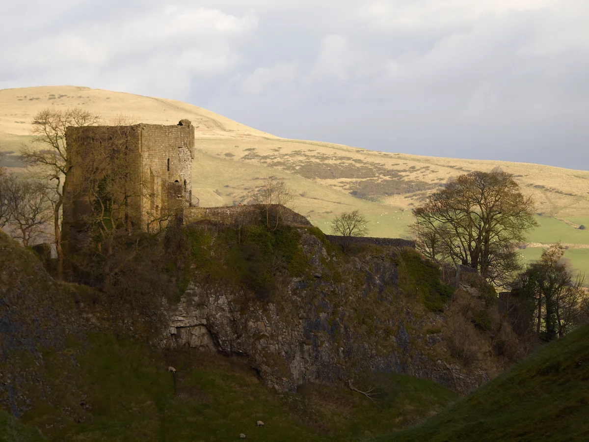
Peakshole Water is a stream in the Derbyshire Peak District of England, named after its source, Peak Cavern. It flows through the village of Castleton to join the River Noe in nearby Hope. Despite its name, much of its flow actually emerges from the Russet Well, a resurgence in a garden on the east side of the gorge below the main Peak Cavern entrance, described as the "main resurgence of the Castleton area", which drains a series of swallets on the other side of the Pennine watershed below Rushup Edge. The resurgence has been explored by cave divers to a depth of 82 feet (25 m) but further exploration was halted by a constriction. The River Noe flows into the Derbyshire Derwent, which in turn leads to the River Trent and thence to the Humber estuary and the North Sea. The stream once powered a corn mill in Castleton which remained in use until about 1920. The 10–12ft diameter water wheel survived until the 1950s. Little is left of the mill, apart from the wheel pit and the mill pond. A public footpath leads from Castleton past the mill and follows close to the stream as far as Pindale Road south of Hope. The stream has one main tributary, Odin Sitch, which rises above Odin Mine on the slopes of Mam Tor and joins Peakshole Water north of the visitor centre in Castleton.
Photo gallery
Official information
Castleton is a picturesque village in the Peak District National Park, known for its stunning landscapes, show caves, and historical sites like Peveril Castle. Visitors can explore various attractions, including a museum and retail area, while enjoying activities suitable for all ages and abilities.
Protected designations
- Site of Special Scientific Interest: Castleton SSSI
Designations sourced from Natural England open data under OGL v3.
From the Wikipedia article
Peakshole Water is a stream in the Derbyshire Peak District of England, named after its source, Peak Cavern. It flows through the village of Castleton to join the River Noe in nearby Hope. Despite its name, much of its flow actually emerges from the Russet Well, a resurgence in a garden on the east side of the gorge below the main Peak Cavern entrance, described as the "main resurgence of the Castleton area", which drains a series of swallets on the other side of the Pennine watershed below Rushup Edge. The resurgence has been explored by cave divers to a depth of 82 feet (25 m) but further exploration was halted by a constriction. The River Noe flows into the Derbyshire Derwent, which in turn leads to the River Trent and thence to the Humber estuary and the North Sea. The stream once powered a corn mill in Castleton which remained in use until about 1920. The 10–12ft diameter water wheel survived until the 1950s. Little is left of the mill, apart from the wheel pit and the mill pond. A public footpath leads from Castleton past the mill and follows close to the stream as far as Pindale Road south of Hope. The stream has one main tributary, Odin Sitch, which rises above Odin Mine on the slopes of Mam Tor and joins Peakshole Water north of the visitor centre in Castleton.
Excerpt from Wikipedia under CC BY-SA 4.0. See the source article linked in Sources below.
- Coordinates
- 53.3419, -1.7783
- County
- Derbyshire
- District
- High Peak
- Parish
- Castleton
- Postcode
- S33 8WX
- Parliamentary constituency
- High Peak
- Nearest railway station
- Hope — 3.3 km
- Opening
- Daily 10am–4pm
- Official site
- www.peakdistrict.gov.uk
Sources
- wikipedia: Peakshole Water (CC BY-SA 4.0)
Other places nearby

Peakshole Sough
Caves · 0.1 km

Peveril Castle Visitor Centre
Castles · 0.1 km

Castleton War Memorial
Memorials & monuments · 0.2 km

Castleton Village Museum
Museums · 0.2 km

Roll of Honour
Memorials & monuments · 0.2 km
Roll of Honour
Memorials & monuments · 0.2 km

Toll Bar Cottage
Memorials & monuments · 0.2 km

Devil's Arse (Peak Cavern)
Caves · 0.2 km
Peveril Castle
Castles · 0.2 km

Technical Speleological Group
Hostels · 0.2 km
Castleton
Villages · 0.3 km

Castleton, Derbyshire
Museums · 0.3 km
Nearby
📷 5Caves · East Midlands
Peakshole Sough
Peakshole Sough — a cave broad in england-east-midlands, United Kingdom.
📷 3Castles · East Midlands
Peveril Castle Visitor Centre
Peveril Castle Visitor Centre — a castle in england-east-midlands, United Kingdom.
📷 3Memorials & monuments · East Midlands
Castleton War Memorial
Castleton War Memorial is a memorial in the United Kingdom.
📷 3Museums · East Midlands
Castleton Village Museum
Castleton Village Museum — a museum in england-east-midlands, United Kingdom.
📷 3Memorials & monuments · East Midlands
Roll of Honour
Roll of Honour is a memorial in the United Kingdom.
📷 3Memorials & monuments · East Midlands
Roll of Honour
Roll of Honour is a memorial in the United Kingdom.
Where to eat & stay near Peakshole Water
Places to stay
📷 5Hostels · East Midlands
Technical Speleological Group
Technical Speleological Group — a hostel in england east midlands.
 📷 5
📷 5Caravan parks · East Midlands
Castleton Caravan and Motorhome Club Site
Castleton Caravan and Motorhome Club Site — a caravan park in england east midlands.
 📷 5
📷 5Campsites · East Midlands
YHA Castleton Losehill Hall
YHA Castleton Losehill Hall — a campsite in england east midlands.
 📷 5
📷 5Hostels · East Midlands
YHA Castleton Losehill Hall
YHA Castleton Losehill Hall — a hostel in england east midlands. Brand: Youth Hostels Association.
📷 5 📷 5
📷 5Campsites · East Midlands
Rowter Farm Campsite
Rowter Farm Campsite — a campsite in england east midlands.
Places to eat & drink
 📷 5
📷 5Historic pubs · East Midlands
The Old Nags Head
The Old Nags Head in England Yorkshire, United Kingdom.
 📷 7
📷 7Historic pubs · East Midlands
The Three Stags' Heads
The Three Stags' Heads in England South East, United Kingdom.
 📷 5
📷 5 📷 5
📷 5Historic pubs · East Midlands
The Chequers Inn and attached outbuildings
The Chequers Inn and attached outbuildings in England East Midlands, United Kingdom.
 📷 7
📷 7Historic pubs · Yorkshire & the Humber
The Fox House
The Fox House in England Yorkshire, United Kingdom.
 📷 5
📷 5Historic pubs · East Midlands
The Eyre Arms Public House
The Eyre Arms Public House in England East Midlands, United Kingdom.
More mountains in this region
 📷 5
📷 5Mountains & hills · East Midlands
Errwood Hall
The ruin of Errwood Hall is a popular tourist destination in the scenic Upper Goyt Valley within the Peak District of England.
 📷 3
📷 3 📷 3
📷 3Mountains & hills · East Midlands
Black Edge - Summit
Black Edge - Summit — Named summit at 506.7 m.
Frequently asked questions
- Where is Peakshole Water?
- Peakshole Water is in Derbyshire, Yorkshire, United Kingdom (postcode S33 8WX), in the parish of Castleton.
- What is Peakshole Water?
- Peakshole Water is a stream in the Derbyshire Peak District of England, named after its source, Peak Cavern. It flows through the village of Castleton to join the River Noe in nearby Hope. Despite its
- How do I get to Peakshole Water?
- The nearest railway station is Hope, about 3.3 km away. Drivers can use postcode S33 8WX.
- Is Peakshole Water a protected site?
- Yes — Peakshole Water is part of the Castleton SSSI Site of Special Scientific Interest.
- Is Peakshole Water free to visit?
- Yes, Peakshole Water is free to enter.
- How do I get to Peakshole Water?
- The nearest railway station is Hope, about 3.3 km away. Drivers can navigate to postcode S33 8WX.