
Natural landmarks · North East England
High Seat
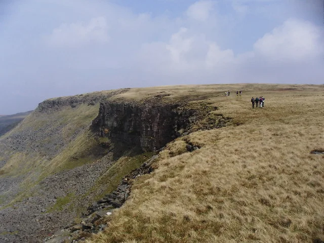
High Seat — mountain in the Yorkshire Dales National Park, England, UK.

Wikimedia Commons contributors — see linked file page for photographer and licence licence

Plan your visit
- Typical visit
- 1 h–2 h
- Nearest railway station
- Kirkby Stephen · 6.8 km
- Free entry
- Dog-friendly
Getting there & planning your visit
To visit High Seat, the nearest railway station is Kirkby Stephen, located 6.8 km away. Admission is free.
About
High Seat is a named natural landmark in the United Kingdom. Wikidata describes it as: "mountain in the Yorkshire Dales National Park, England, UK". Coordinates: 54.4060°, -2.3050°.
Photo gallery
Protected designations
- Site of Special Scientific Interest: Mallerstang-Swaledale Head SSSI
- Site of Special Scientific Interest: River Eden and Tributaries SSSI
Designations sourced from Natural England open data under OGL v3.
From the Wikipedia article
High Seat is a fell in the dale of Mallerstang, Cumbria. With a summit at 709 metres (2,326 ft), it is the fourth highest fell in the Yorkshire Dales after Whernside, Ingleborough and Great Shunner Fell. It is in the north-western part of the Dales, overlooking the deep trench of Mallerstang, and is usually climbed from this side. To the south-east is Hugh Seat (whose summit is marked by Lady Anne's Pillar, commemorating Sir Hugh de Morville). On the opposite (western) side of Mallerstang is the more striking (but 1 metre lower) Wild Boar Fell. It is not a Marilyn, having a relative height of 112 m, and therefore may be regarded as a subsidiary top of Great Shunner Fell, to the east. It is, however, a HuMP. Oddly enough, it is the highest point on the main England east-to-west watershed in the Dales, the three higher fells being some distance from the watershed. Three main rivers have their origins in the peat bogs here: the River Eden, the River Swale, and the River Ure.
Excerpt from Wikipedia under CC BY-SA 4.0. See the source article linked in Sources below.
- Coordinates
- 54.4060, -2.3050
- Address
- Yorkshire Dales, England
- Nearest railway station
- Kirkby Stephen — 6.8 km
Sources
- wikidata: Q5756668 (CC0)
- wikipedia: High Seat (Yorkshire Dales) (CC BY-SA 4.0)
- commons: Mallerstang.jpg (CC BY-SA 4.0)
Other places nearby
High Seat
Mountains & hills · 0.1 km

Whitebank Hill
Mountains & hills · 0.7 km

Gregory Chapel
Natural landmarks · 1.0 km

Brockholes Force
Waterfalls · 1.2 km

Thrang Force
Waterfalls · 1.9 km

Outhgill
Historic churches · 2.0 km

Outhgill Pinfold
Public art & sculpture · 2.0 km

Uldale Force
Waterfalls · 2.0 km

High Pike Hill
Mountains & hills · 2.1 km

Mallerstang
National parks · 2.1 km

Outhgill
Villages · 2.1 km

Hugh Seat
Natural landmarks · 2.2 km
Nearby
📷 3📷 5Mountains & hills · North West England
Whitebank Hill
Whitebank Hill — mountain in england north west. Elevation: 673 m.
📷 3Natural landmarks · North West England
Gregory Chapel
Gregory Chapel — mountain in United Kingdom.
📷 5📷 5📷 4Where to eat & stay near High Seat
Places to stay
 📷 5
📷 5Campsites · North East England
Hoggarths campsite
Hoggarths campsite — a campsite in england north west.
 📷 5
📷 5Campsites · North West England
Pennine View Park
Pennine View Park — a campsite in england north west.
 📷 5
📷 5Hostels · North West England
Kirkby Stephen Hostel
Kirkby Stephen Hostel — a hostel in england north west.
 📷 7
📷 7B&Bs · North West England
Fletcher House
Fletcher House — a bed-and-breakfast in england north west.
 📷 7
📷 7Hotels · North West England
Black Bull Hotel
Black Bull Hotel — a hotel in england north west.
 📷 7
📷 7Hotels · North West England
The Pennine Hotel
The Pennine Hotel — a hotel in england north west.
Places to eat & drink
📷 7Cafés · North West England
The White Hare Cafe
The White Hare Cafe — a café in england north west.
 📷 5
📷 5 📷 5
📷 5Cafés · North West England
The Cross Keys Temperance Inn
The Cross Keys Temperance Inn — a café in england north west.
 📷 5
📷 5Historic pubs · Yorkshire & the Humber
Kings Head Inn
Kings Head Inn in England North West, United Kingdom.
 📷 5
📷 5Cafés · North West England
Gun Dog Coffee Shop
Gun Dog Coffee Shop — a café in england north west.
 📷 5
📷 5More natural landmarks in this region
 📷 4
📷 4Natural landmarks · North East England
Cleveland Way
109-mile horseshoe trail around the North York Moors and its sea cliffs.
 📷 3
📷 3Natural landmarks · North East England
The Hand Stone
The Hand Stone — a other in england-yorkshire, United Kingdom.
 📷 3
📷 3Natural landmarks · North East England
The Face Stone
The Face Stone — a other in england-yorkshire, United Kingdom.
 📷 3
📷 3Frequently asked questions
- Where is High Seat?
- High Seat is in North-West England, United Kingdom.
- What is High Seat?
- High Seat — mountain in the Yorkshire Dales National Park, England, UK.
- How do I get to High Seat?
- The nearest railway station is Kirkby Stephen, about 6.8 km away. Its coordinates are 54.4060°, -2.3050°.
- Is High Seat a protected site?
- Yes — High Seat is part of the Mallerstang-Swaledale Head SSSI Site of Special Scientific Interest and the River Eden and Tributaries SSSI Site of Special Scientific Interest.
- Is High Seat free to visit?
- Yes, High Seat is free to enter.
- How do I get to High Seat?
- The nearest railway station is Kirkby Stephen, about 6.8 km away.