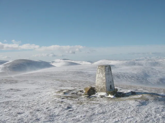
Natural landmarks · North East England
Cleveland Way
In or near Great Broughton.
109-mile horseshoe trail around the North York Moors and its sea cliffs.

Peter Church — CC BY-SA 2.0 via Wikimedia Commons licence
Plan your visit
- Typical visit
- 1 h–2 h
- Nearest railway station
- Castleton Moor · 8.2 km
- Free entry
- Dog-friendly
Getting there & planning your visit
Cleveland Way is located in Yorkshire, with the nearest railway station being Castleton Moor, which is 8.2 km away. Entry to the site is free. Accessibility details are not provided.
About
The Cleveland Way is the National Trail (1969) running 109 miles around the North York Moors National Park — half across moorland from Helmsley to Saltburn, then along the dramatic North Sea cliffs to Filey.
Photo gallery
Official information
The Cleveland Way is a 109-mile walking trail that traverses the stunning landscapes of the North York Moors National Park and the dramatic Yorkshire coastline. It begins in Helmsley and ends at Filey, offering a variety of scenic views, historical sites, and charming coastal towns along the route. The trail is suitable for reasonably fit walkers and can be enjoyed year-round.
Protected designations
- Site of Special Scientific Interest: North York Moors SSSI
Designations sourced from Natural England open data under OGL v3.
From the Wikipedia article
The Cleveland Way is a National Trail in the historic area of Cleveland in North Yorkshire, Northern England. It runs 110 miles (177 km) between Helmsley and the Brigg at Filey, through the west, north and east of the North York Moors National Park.
Excerpt from Wikipedia under CC BY-SA 4.0. See the source article linked in Sources below.
Background
History
Development of the Cleveland Way began in the 1930s when the Teesside Ramblers' Association pressed for the creation of a long-distance path in the north-east of Yorkshire linking the Hambleton Drove Road, the Cleveland escarpment and footpaths on the Yorkshire coast. Subsequently, in 1953, a formal proposal to create the route was submitted to the North Riding of Yorkshire Council by the National Parks Commission. The trail was officially opened in 1969. It was the second official National Trail to be opened.
Visiting
The path is accessible at a number of points, including the following: {| class="wikitable" style="border:0px; text-align:left; line-height:150%" ! scope="col" |Location ! scope="col" |From Helmsley ! scope="col" |Notes |- | Helmsley | - | A market town on the south western edge of the moors. Accessible by car or by regular bus service. |- | Rievaulx Abbey | 2.8 miles | A former Cistercian abbey in an isolated valley in the Hambleton Hills to the west of Helmsley. Accessible by car. |- | Sutton Bank | 10.2 miles | A hill on the Hambleton Hills with extensive views over the Vale of York and the Vale of Mowbray, with a National Park visitor centre. The Kilburn White Horse is nearby.…
Sourced from Wikipedia under CC BY-SA 4.0.
- Coordinates
- 54.4000, -1.0000
- Address
- North Yorkshire, England
- Established
- 1969
- Nearest railway station
- Castleton Moor — 8.2 km
- Official site
- www.nationaltrail.co.uk
Sources
- manual: cleveland-way (manual)
- wikipedia: Cleveland Way (CC BY-SA 4.0)
Other places nearby

Karl Briggs
Memorials & monuments · 2.2 km

Margery Bradley
Memorials & monuments · 2.5 km

The Margery Bradley standing stone
Historic houses · 2.5 km

Ledging Hill
Mountains & hills · 2.5 km

Stony Ridge
Mountains & hills · 2.6 km

Cammon Stone
Natural landmarks · 2.6 km

Old Ralph
Memorials & monuments · 2.6 km

Cockan Cross
Memorials & monuments · 2.7 km

Young Ralph
Memorials & monuments · 2.9 km

Fat Betty
Memorials & monuments · 3.4 km

Cockayne Ridge
Mountains & hills · 3.7 km

Farndale
Gorges · 3.9 km
Nearby
📷 3Memorials & monuments · Yorkshire & the Humber
Karl Briggs
Karl Briggs — a memorial in england-yorkshire, United Kingdom.
📷 4Memorials & monuments · Yorkshire & the Humber
Margery Bradley
Margery Bradley is a memorial in the United Kingdom.
📷 3Historic houses · Yorkshire & the Humber
The Margery Bradley standing stone
The Margery Bradley standing stone — a Grade II*-listed historic house in england-yorkshire, United Kingdom.
📷 5Mountains & hills · North East England
Ledging Hill
Ledging Hill — mountain in england yorkshire. Elevation: 429 m.
📷 5Mountains & hills · Yorkshire & the Humber
Stony Ridge
Stony Ridge — mountain in england yorkshire. Elevation: 433 m.
📷 3Natural landmarks · Yorkshire & the Humber
Cammon Stone
Cammon Stone — a other in england-yorkshire, United Kingdom.
Where to eat & stay near Cleveland Way
Places to stay
 📷 5
📷 5Campsites · Yorkshire & the Humber
Low Bell End Farm Campsite
Low Bell End Farm Campsite — a campsite in england yorkshire.
 📷 5
📷 5Caravan parks · Yorkshire & the Humber
Rosedale Touring Caravan Park
Rosedale Touring Caravan Park — a caravan park in england yorkshire.
 📷 5
📷 5Campsites · Yorkshire & the Humber
Kildale Camping & Barn
Kildale Camping & Barn — a campsite in england yorkshire.
 📷 5
📷 5Hotels · Yorkshire & the Humber
The Milburn Arms Hotel
The Milburn Arms Hotel — a hotel in england yorkshire.
 📷 5
📷 5Campsites · Yorkshire & the Humber
Raven Gill Campsite
Raven Gill Campsite — a campsite in england yorkshire.
 📷 5
📷 5Campsites · Yorkshire & the Humber
Lawnsgate Campsite
Lawnsgate Campsite — a campsite in england yorkshire.
Places to eat & drink
 📷 4
📷 4Historic pubs · North East England
The Dudley Arms Public House
The Dudley Arms Public House in England North East, United Kingdom.
 📷 7
📷 7 📷 5
📷 5Historic pubs · North East England
The Royal Oak Hotel
The Royal Oak Hotel in England North East, United Kingdom.
 📷 7
📷 7Historic pubs · North East England
The Queen's Head Public House
The Queen's Head Public House in England North East, United Kingdom.
 📷 5
📷 5Historic pubs · Yorkshire & the Humber
Birch Hall Inn
Birch Hall Inn in England Yorkshire, United Kingdom.
 📷 7
📷 7Historic pubs · Yorkshire & the Humber
The Black Swan And Railings To Front
The Black Swan And Railings To Front in England Yorkshire, United Kingdom.
Other natural landmarks from this era
_(cropped).JPG?width=1200) 📷 5
📷 5Natural landmarks · London
George Stuart White
George Stuart White — Public artwork (statue).
 📷 5
📷 5 📷 5
📷 5Natural landmarks · London
John Keats
John Keats — Public artwork (statue) by Stuart Williamson.
 📷 5
📷 5More natural landmarks in this region
 📷 3
📷 3Natural landmarks · North East England
The Hand Stone
The Hand Stone — a other in england-yorkshire, United Kingdom.
 📷 3
📷 3Natural landmarks · North East England
The Face Stone
The Face Stone — a other in england-yorkshire, United Kingdom.
 📷 3
📷 3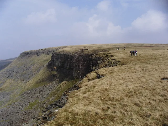 📷 3
📷 3Natural landmarks · North East England
High Seat
High Seat — mountain in the Yorkshire Dales National Park, England, UK.
Frequently asked questions
- Where is Cleveland Way?
- Cleveland Way is in Yorkshire, United Kingdom.
- What is Cleveland Way?
- 109-mile horseshoe trail around the North York Moors and its sea cliffs.
- How do I get to Cleveland Way?
- The nearest railway station is Castleton Moor, about 8.2 km away. Its coordinates are 54.4000°, -1.0000°.
- When was Cleveland Way built?
- Built or established in 1969.
- Is Cleveland Way a protected site?
- Yes — Cleveland Way is part of the North York Moors SSSI Site of Special Scientific Interest.
- Is Cleveland Way free to visit?
- Yes, Cleveland Way is free to enter.