Mountains & hills · North West England
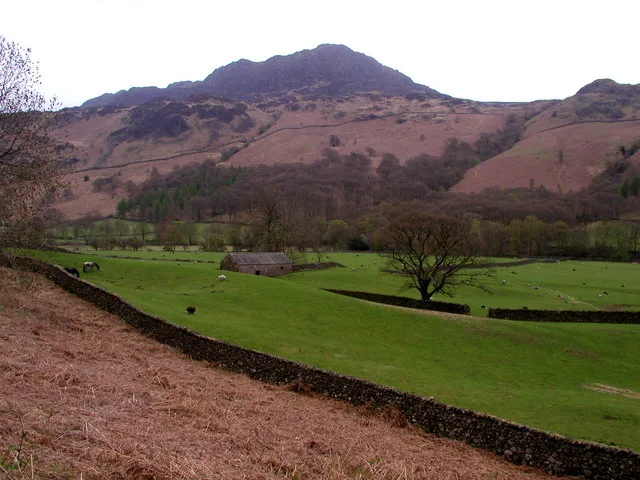
Harter Fell (Eskdale)
Harter Fell (Eskdale) — a hill or mountain in england north west.

Michael Graham — CC BY-SA 2.0 via Wikimedia Commons licence
Plan your visit
- Typical visit
- 3 h–8 h
- Best time of year
- Late spring – early autumn (May–Oct)
About
A British hill or mountain, named on Ordnance Survey maps and walked by hill-baggers. Harter Fell (Eskdale) is a named hill or mountain in england north west, recorded in the GeoNames UK gazetteer. British landmarks of this type are typically marked on Ordnance Survey maps and recorded in the national gazetteer for cartographic and navigational reference. Coordinates and feature classification are sourced from the GeoNames open dataset.
Photo gallery
Place summary
Harter Fell is a mountain located in Eskdale, North-West England. It is known for its rugged terrain and panoramic views of the surrounding Lake District landscape. The area is popular for walking and hiking, attracting outdoor enthusiasts seeking both challenge and scenery. Its elevation offers a prominent vantage point for appreciating the natural beauty of the region.
AI-generated from the structured facts on this page (operator, designation, listing, era). Not a substitute for visiting.
- Coordinates
- 54.3869, -3.2045
Sources
- manual: geonames-6694107 (CC BY 4.0)
Other places nearby
Loading nearby places…
Nearby
 📷 3
📷 3Mountains & hills · North West England
Harter Fell
Harter Fell — Named summit at 653.2 m.
 📷 3
📷 3Natural landmarks · North West England
Harter Fell
Harter Fell — mountain in Eskdale, Cumberland, Cumbria, England.
 📷 4
📷 4Historic bridges · North West England
Birks Bridge
Birks Bridge — Grade II listed building-listed bridge in england-north-west, United Kingdom.
 📷 5
📷 5Archaeological sites · North West England
Hardknott Roman Fort
Hardknott Roman Fort — archaeological in england north west. Operated by English Heritage.
 📷 5
📷 5Archaeological sites · North West England
Hardknott Roman Fort
Hardknott Roman Fort is an archeological site, the remains of the Roman fort Mediobogdum, located on the western side of the challenging Hardknott Pass in the English Lake District. The fort was built
 📷 3
📷 3Historic bridges · North West England
Wha House Bridge
Wha House Bridge is a historic bridge in the United Kingdom.
Where to eat & stay near Harter Fell (Eskdale)
Places to stay
 📷 5
📷 5Hostels · North West England
YHA Eskdale
YHA Eskdale — a hostel in england north west.
 📷 5
📷 5Campsites · North West England
Turner Hall Farm Campsite
Turner Hall Farm Campsite — a campsite in england north west.
 📷 5
📷 5Campsites · North West England
Eskdale Campsite
Eskdale Campsite — a campsite in england north west.
 📷 5
📷 5Campsites · North West England
Fisherground Campsite
Fisherground Campsite — a campsite in england north west.
 📷 5
📷 5Hostels · North West England
YHA Coppermines
YHA Coppermines — a hostel in england north west.
 📷 5
📷 5Hostels · North West England
Yorkshire Mountaineering Club Hut
Yorkshire Mountaineering Club Hut — a hostel in england north west.
Places to eat & drink
 📷 5
📷 5Historic pubs · North West England
Church House Public House
Church House Public House in England North West, United Kingdom.
 📷 5
📷 5Historic pubs · North West England
Blacksmiths Arms
Blacksmiths Arms in England North West, United Kingdom.
 📷 5
📷 5Restaurants · North West England
The Terrace Coffee House and Restaurant
The Terrace Coffee House and Restaurant — a restaurant in england north west. Cuisine: sandwich;lunch.
 📷 5
📷 5Historic pubs · North West England
Sun Cottage Sun Inn Public House
Sun Cottage Sun Inn Public House in England North West, United Kingdom.
 📷 5
📷 5Historic pubs · North West England
The Travellers Rest
The Travellers Rest in England North West, United Kingdom.
 📷 5
📷 5Historic pubs · North West England
Golden Rule Hotel
Golden Rule Hotel in England North West, United Kingdom.
More mountains in this region
 📷 3
📷 3Mountains & hills · North West England
Allen Crags
Allen Crags — Named summit at 785 m.
 📷 3
📷 3Mountains & hills · North West England
Alum Pot
Alum Pot — Open shaft pothole in North Yorkshire.
 📷 3
📷 3Mountains & hills · North West England
Arnside Knott
Arnside Knott — Named summit at 159 m.
 📷 3
📷 3Mountains & hills · North West England
Aye Gill Pike
Aye Gill Pike — Named summit at 556.3 m.
Frequently asked questions
- Where is Harter Fell (Eskdale)?
- Harter Fell (Eskdale) is in North-West England, United Kingdom.
- What is Harter Fell (Eskdale)?
- Harter Fell (Eskdale) — a hill or mountain in england north west.
- How do I get to Harter Fell (Eskdale)?
- Its coordinates are 54.3869°, -3.2045°.