Mountains & hills · North West England
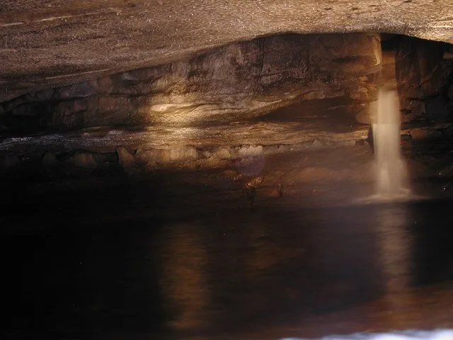
Alum Pot
In or near Horton in Ribblesdale.
Alum Pot — Open shaft pothole in North Yorkshire.

Wikimedia Commons contributors — see linked file page for photographer and licence licence
Plan your visit
- Typical visit
- 3 h–8 h
- Best time of year
- Late spring – early autumn (May–Oct)
- Nearest railway station
- Ribblehead · 3.5 km
- Free entry
- Dog-friendly
Getting there & planning your visit
To visit Alum Pot, the nearest railway station is Ribblehead, located 3.5 km away. Entry to the site is free. The postcode for navigation is BD24 0HZ.
About
Alum Pot is a named summit in the United Kingdom. Wikidata describes it as: "Open shaft pothole in North Yorkshire". Coordinates: 54.1750°, -2.3458°.
Photo gallery
Protected designations
- Site of Special Scientific Interest: Ingleborough SSSI
- National Nature Reserve: INGLEBOROUGH
Designations sourced from Natural England open data under OGL v3.
From the Wikipedia article
Alum Pot is a pothole with a large open shaft at a surface elevation of 343 metres (1,125 ft) on the eastern flanks of Simon Fell, North Yorkshire, England. It connects with nearby Long Churn Cave and Diccan Pot. The pot is accessed via a 1-km private track on payment of a small fee from Selside Farm in the hamlet of Selside in Ribblesdale. Alum Pot has variously been known as Allan, Alan, Allen, Hellen and Hell'n.
Excerpt from Wikipedia under CC BY-SA 4.0. See the source article linked in Sources below.
Background
History
In 1847 John Birkbeck undertook the first partial descent of Alum Pot from Long Churn Cave which did not reach the floor of the shaft. He returned the following year and made a successful descent, when a group of nine men were lowered to the shaft floor in a large bucket winched down by a group of railway workers. In 1932 a 24-strong group of cavers from the Craven Pothole Club made the first passage from Alum Pot to Diccan Pot. In July 1936 Mabel Binks became the first caving fatality in the Yorkshire Dales when she was hit by a rock falling down the Main Shaft. Evidence from the inquest indicated that it had been thrown down deliberately.
Sourced from Wikipedia under CC BY-SA 4.0.
- Coordinates
- 54.1750, -2.3458
- District
- North Yorkshire
- Parish
- Horton in Ribblesdale
- Postcode
- BD24 0HZ
- Parliamentary constituency
- Skipton and Ripon
- Nearest railway station
- Ribblehead — 3.5 km
Sources
- wikidata: Q4737334 (CC0)
- wikipedia: Alum Pot (CC BY-SA 4.0)
- commons: Alum Pot - geograph.org.uk - 147334.jpg (CC BY-SA 4.0)
Other places nearby

Alum Pot
Caves · 0.1 km

Diccan Pot
Caves · 0.2 km
Diccan Pot
Caves · 0.2 km
Long Churn Cave
Mountains & hills · 0.2 km
Lower Long Churn Cave
Caves · 0.2 km
Upper Long Churn Cave
Caves · 0.3 km
Wilson's Cave
Caves · 0.4 km
November Hole
Caves · 0.4 km
November Hole
Caves · 0.4 km
Borrins Moor Cave
Caves · 0.5 km

Gill Garth Hill
Mountains & hills · 1.0 km

Washfold Pot
Caves · 1.0 km
Nearby
📷 3📷 5📷 5Caves · North West England
Diccan Pot
Diccan Pot — a cave broad in england-north-west, United Kingdom.
📷 3Mountains & hills · North West England
Long Churn Cave
Long Churn Cave — Cave in North Yorkshire, England.
📷 5📷 5Where to eat & stay near Alum Pot
Places to stay
 📷 5
📷 5Hostels · North West England
The Station Inn Bunkhouse
The Station Inn Bunkhouse — a hostel in england north west.
 📷 5
📷 5Caravan parks · North West England
The Rowe House
The Rowe House — a caravan park in england north west.
 📷 5
📷 5Campsites · North West England
Philpin Farm Campsite
Philpin Farm Campsite — a campsite in england north west.
 📷 5
📷 5 📷 5
📷 5Campsites · North West England
Ribblesdale Pods
Ribblesdale Pods — a campsite in england north west.
 📷 5
📷 5Campsites · North West England
Broad Croft House Camping Pods
Broad Croft House Camping Pods — a campsite in england north west.
Places to eat & drink
 📷 5
📷 5Cafés · North West England
Lakehouse Food & Drink
Lakehouse Food & Drink — a café in england north west.
 📷 5
📷 5Restaurants · North West England
The Game Cock Inn
The Game Cock Inn — a restaurant in england north west. Cuisine: french;english.
 📷 5
📷 5Historic pubs · North West England
Horse And Farrier Inn
Horse And Farrier Inn in England North West, United Kingdom.
 📷 5
📷 5Historic pubs · North West England
Punch Bowl Hotel
Punch Bowl Hotel in England North West, United Kingdom.
 📷 6
📷 6Historic pubs · North West England
Falcon Manor Hotel
Falcon Manor Hotel in England North West, United Kingdom.
 📷 5
📷 5More mountains in this region
 📷 5
📷 5Mountains & hills · North West England
Appleton Park
Appleton Park — a hill or mountain in england west midlands.
 📷 5
📷 5Mountains & hills · North West England
High Warren
High Warren — mountain in england west midlands. Elevation: 105 m.
 📷 5
📷 5Mountains & hills · North West England
Alderley Edge
Alderley Edge — mountain in england west midlands. Elevation: 194 m.
 📷 3
📷 3Frequently asked questions
- Where is Alum Pot?
- Alum Pot is in North-West England, United Kingdom (postcode BD24 0HZ), in the parish of Horton in Ribblesdale.
- What is Alum Pot?
- Alum Pot — Open shaft pothole in North Yorkshire.
- How do I get to Alum Pot?
- The nearest railway station is Ribblehead, about 3.5 km away. Drivers can use postcode BD24 0HZ.
- Is Alum Pot a protected site?
- Yes — Alum Pot is part of the Ingleborough SSSI Site of Special Scientific Interest and the INGLEBOROUGH National Nature Reserve.
- Is Alum Pot free to visit?
- Yes, Alum Pot is free to enter.
- How do I get to Alum Pot?
- The nearest railway station is Ribblehead, about 3.5 km away. Drivers can navigate to postcode BD24 0HZ.