
Islands · East of England
Foulness Island
Also known as: Foulness
In or near Althorne.
Foulness Island — island in Rochford, Essex, England.

Wikimedia Commons licence
Plan your visit
- Typical visit
- 4 h–12 h
- Nearest railway station
- Burnham-on-Crouch · 6.9 km
- Free entry
- Dog-friendly
Getting there & planning your visit
Foulness Island is located in Essex, with the nearest railway station being Burnham-on-Crouch, approximately 6.9 km away. Entry to the island is free.
About
Foulness Island is a island in the United Kingdom. Recent population estimates put it at around 151 people. Address: SS3. Wikidata describes it as: "island in Rochford, Essex, England". Coordinates: 51.5976°, 0.8954°.
Photo gallery
Protected designations
- Site of Special Scientific Interest: Crouch and Roach Estuaries SSSI
- Site of Special Scientific Interest: Foulness SSSI
- Ramsar wetland: Foulness (Mid-Essex Coast Phase 5)
Designations sourced from Natural England open data under OGL v3.
From the Wikipedia article
Foulness Island () is an island in Essex, England, in the Thames estuary. It is separated from the mainland by narrow creeks. The island is usually closed to the general public, having been taken over for military use in 1914. The island forms a civil parish called Foulness, which had a population of 158 at the 2021 census. The main settlements on the island are Churchend and Courtsend, both at the northern end of the island. By July 2022 the general store and post office in Churchend had been abandoned. The George and Dragon pub in Churchend closed in 2007, while the church of St Mary the Virgin closed in May 2010. In 2019, the Southend Echo reported plans for the church to be converted into a five-bedroom home. Foulness Island is predominantly farmland and is protected from the sea by a sea wall. The island's unusual name is derived from the Old English fugla næsse ("bird headland"), referring to wildfowl. It is an internationally important site for migrating and breeding birds, including pied avocets. During the North Sea flood of 1953, almost the entire island was flooded and two people died. Before 1922, when the military road was built, the only access was across the Maplin Sands via the Broomway, a tidal path said to predate the Romans, or by boat. Public rights of way exist, but the island is now run by QinetiQ on behalf of the Ministry of Defence as MoD Shoeburyness with access to the island by non-residents subject to stringent times and restrictions.
Excerpt from Wikipedia under CC BY-SA 4.0. See the source article linked in Sources below.
- Coordinates
- 51.5976, 0.8954
- County
- Essex
- District
- Rochford
- Parish
- Foulness
- Postcode
- SS3
- Parliamentary constituency
- Southend East and Rochford
- Population
- 151
- Nearest railway station
- Burnham-on-Crouch — 6.9 km
Sources
- wikidata: Q5474214 (CC0)
- wikipedia: Foulness Island (CC BY-SA 4.0)
Other places nearby

The George And Dragon Public House
Historic pubs · 0.5 km

Foulness Island War Memorial
Memorials & monuments · 0.5 km
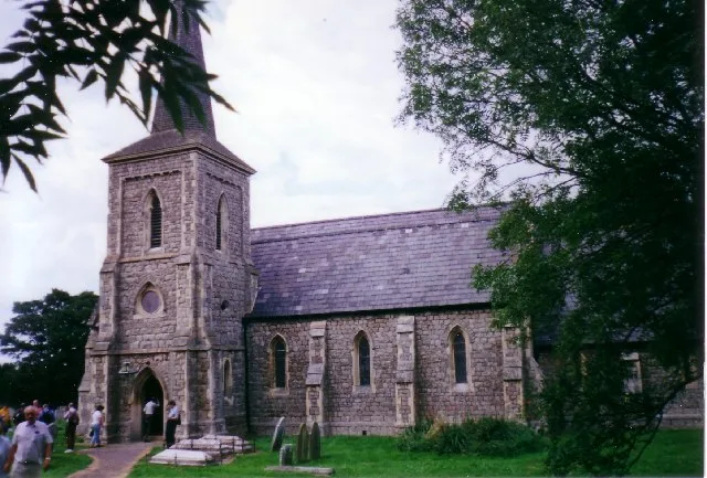
Saint Mary the Virgin, Foulness Island
Historic churches · 0.5 km

Foulness
Villages · 0.5 km

School House Viewpoint
Viewpoints · 2.6 km

River Roach
Museums · 2.7 km

Crouch harbour
Marinas · 3.0 km

Half Moon Viewpoint
Viewpoints · 3.1 km

Wallasea Wetlands
Wildlife reserves · 3.4 km

New England Island
Islands · 4.1 km

Wallasea Island
Islands · 4.3 km

River Crouch
Museums · 4.4 km
Nearby
📷 5Historic pubs · East of England
The George And Dragon Public House
The George And Dragon Public House in England East, United Kingdom.
📷 3Memorials & monuments · East of England
Foulness Island War Memorial
Foulness Island War Memorial — Grade II listed building-listed memorial in england-east, United Kingdom.
📷 3Historic churches · East of England
Saint Mary the Virgin, Foulness Island
Saint Mary the Virgin, Foulness Island — grade II listed church in Foulness, Rochford, Essex, England, UK.
📷 5📷 3Viewpoints · East of England
School House Viewpoint
School House Viewpoint is a viewpoint in the United Kingdom.
📷 3Museums · East of England
River Roach
River Roach — a museum in england-east, United Kingdom.
Where to eat & stay near Foulness Island
Places to stay
 📷 5
📷 5Caravan parks · East of England
Sea End Caravan Park
Sea End Caravan Park — a caravan park in england east.
 📷 5
📷 5Caravan parks · East of England
Silver Road Caravan Park
Silver Road Caravan Park — a caravan park in england east.
 📷 5
📷 5Hotels · East of England
Ye Olde White Harte Hotel
Ye Olde White Harte Hotel — a hotel in england east.
 📷 5
📷 5Campsites · East of England
Huntsman & Hounds Camping
Huntsman & Hounds Camping — a campsite in england east.
 📷 5
📷 5Caravan parks · East of England
Waterside Holiday Park
Waterside Holiday Park — a caravan park in england east.
 📷 5
📷 5Caravan parks · East of England
St Lawrence Holiday Park
St Lawrence Holiday Park — a caravan park in england east.
Places to eat & drink
📷 5Historic pubs · East of England
The George And Dragon Public House
The George And Dragon Public House in England East, United Kingdom.
 📷 5
📷 5Historic pubs · East of England
The Fox And Hounds
The Fox And Hounds in England East, United Kingdom.
 📷 5
📷 5Historic pubs · East of England
The Cherry Tree Public House
The Cherry Tree Public House in England South East, United Kingdom.
 📷 5
📷 5Historic pubs · East of England
The Black Lion Public House
The Black Lion Public House in England East, United Kingdom.
 📷 5
📷 5Historic pubs · East of England
The Mayland Mill Public House
The Mayland Mill Public House in England East, United Kingdom.
 📷 5
📷 5Historic pubs · East of England
Cottages And The Golden Lion Public House
Cottages And The Golden Lion Public House in England South East, United Kingdom.
More places in this region
 📷 4📷 3
Islands · East of England
New England Island
New England Island — island in Essex, United Kingdom.
 📷 5
📷 5 Flagship📷 5
Frequently asked questions
- Where is Foulness Island?
- Foulness Island is in Essex, East of England, United Kingdom (postcode SS3), in the parish of Foulness.
- What is Foulness Island?
- Foulness Island — island in Rochford, Essex, England.
- How do I get to Foulness Island?
- The nearest railway station is Burnham-on-Crouch, about 6.9 km away. The nearest town is Althorne. Drivers can use postcode SS3.
- Is Foulness Island a protected site?
- Yes — Foulness Island is part of the Crouch and Roach Estuaries SSSI Site of Special Scientific Interest and the Foulness SSSI Site of Special Scientific Interest.
- Is Foulness Island free to visit?
- Yes, Foulness Island is free to enter.
- How do I get to Foulness Island?
- The nearest railway station is Burnham-on-Crouch, about 6.9 km away. Drivers can navigate to postcode SS3.