Watermills · North East England
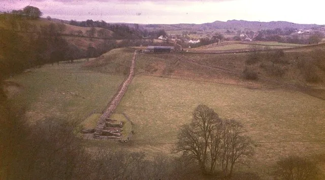
Poltross Burn
In or near Greenhead.
Poltross Burn in England North East, United Kingdom.

P Beaver — CC BY-SA 2.0 via Wikimedia Commons licence
Plan your visit
- Typical visit
- 30 min–1 h
- Nearest railway station
- Haltwhistle · 7.6 km
- Free entry
- Family-friendly
- Dog-friendly
Getting there & planning your visit
To visit Poltross Burn, the nearest railway station is Haltwhistle, located 7.6 km away. Entry is free, and the postcode for sat-nav is CA8 7BG.
About
Poltross Burn is a place of interest in England North East, United Kingdom — drawn from open-data sources for visitor reference. See the linked Wikipedia article for the full description.
Photo gallery
See it from the streetimagery from 2022
Imagery © Mapillary contributors, CC BY-SA 4.0
Protected designations
- Site of Special Scientific Interest: River Eden and Tributaries SSSI
Designations sourced from Natural England open data under OGL v3.
From the Wikipedia article
The Poltross Burn is a tributary of the River Irthing. The burn rises on Denton Fell and flows north-east, joining the Irthing at Gilsland. The well-preserved Roman Milecastle 48, a feature of Hadrian's Wall once known locally as The King's Stables, stands on the west bank. It is signposted as Poltross Burn Milecastle, and adjoins the south side of the railway embankment in Gilsland. A 19th-century watermill within the village used the burn as a source of power to grind corn.
Excerpt from Wikipedia under CC BY-SA 4.0. See the source article linked in Sources below.
- Coordinates
- 54.9915, -2.5743
- District
- Northumberland
- Parish
- Thirlwall
- Postcode
- CA8 7BG
- Parliamentary constituency
- Hexham
- Nearest railway station
- Haltwhistle — 7.6 km
Sources
- wikidata: Q7226047 (CC0)
- wikipedia: Poltross Burn (CC BY-SA 4.0)
Other places nearby
Gilsland
Other places · 0.1 km

Mumps Hall
Historic houses · 0.1 km

Poltross Burn Milecastle
Archaeological sites · 0.3 km

Poltross Burn Milecastle
Archaeological sites · 0.3 km
Milecastle 48
Other places · 0.3 km

Gilsland railway station
Heritage railway stations · 0.3 km

Roman watch tower
Archaeological sites · 0.4 km

Hadrians Wall Milecastle And Turrets Hadrians Wall, Milecastle And Turrets
Castles · 0.5 km
Hadrian's Wall and vallum and their associated features between Poltross Burn and the River Irthing in wall mile 48
Archaeological sites · 0.5 km

THROP ROMAN FORTLET
Archaeological sites · 0.6 km

THROP ROMAN FORTLET
Archaeological sites · 0.6 km
St. Mary Magdalene's Church, Gilsland
Historic churches · 0.8 km
Nearby
📷 5📷 3Historic houses · North East England
Mumps Hall
Mumps Hall — former inn in Gilsland, Cumbria, England, UK.
📷 3Archaeological sites · North East England
Poltross Burn Milecastle
Poltross Burn Milecastle — a archaeological in scotland-lowlands, United Kingdom.
📷 5Archaeological sites · North East England
Poltross Burn Milecastle
Poltross Burn Milecastle — archaeological in scotland lowlands.
📷 5Other places · North East England
Milecastle 48
Milecastle 48 (Poltross Burn) is a milecastle on Hadrian's Wall (grid reference NY6340666195). Its remains lie near the village of Gilsland in Cumbria where it was historically known as "The King's St
📷 4Heritage railway stations · North East England
Gilsland railway station
Gilsland railway station in England North East, United Kingdom.
Where to eat & stay near Poltross Burn
Places to stay
 📷 5
📷 5Campsites · North East England
Chapel house farm walkers campsite
Chapel house farm walkers campsite — a campsite in scotland lowlands.
 📷 5
📷 5Hostels · North East England
Greenhead Hostel
Greenhead Hostel — a hostel in scotland lowlands.
 📷 5
📷 5Caravan parks · North East England
Blenkinsopp Castle Home Park
Blenkinsopp Castle Home Park — a caravan park in scotland lowlands.
 📷 5
📷 5Caravan parks · North West England
Cleugh Head Caravan Club
Cleugh Head Caravan Club — a caravan park in scotland lowlands.
 📷 5
📷 5Campsites · North West England
Camping at Banks
Camping at Banks — a campsite in scotland lowlands.
 📷 5
📷 5Campsites · North East England
Haltwhistle - Camping and Caravanning Club Site
Haltwhistle - Camping and Caravanning Club Site — a campsite in scotland lowlands.
Places to eat & drink
 📷 4
📷 4 📷 4
📷 4Historic pubs · North West England
Hallbankgate
Hallbankgate in England North East, United Kingdom.
 📷 5
📷 5Historic pubs · North West England
Graham Arms (West Of Gelt Bridge)
Graham Arms (West Of Gelt Bridge) in Scotland Lowlands, United Kingdom.
 📷 5
📷 5 📷 7
📷 7Historic pubs · North East England
Anchor Hotel
Anchor Hotel in Scotland Lowlands, United Kingdom.
More watermills in this region
 📷 3
📷 3 📷 4
📷 4Watermills · North East England
Rutter Force
Rutter Force in England North East, United Kingdom.
 📷 4
📷 4 📷 4
📷 4Frequently asked questions
- Where is Poltross Burn?
- Poltross Burn is in North-East England, United Kingdom (postcode CA8 7BG), in the parish of Thirlwall.
- What is Poltross Burn?
- Poltross Burn in England North East, United Kingdom.
- How do I get to Poltross Burn?
- The nearest railway station is Haltwhistle, about 7.6 km away. Drivers can use postcode CA8 7BG.
- Is Poltross Burn a protected site?
- Yes — Poltross Burn is part of the River Eden and Tributaries SSSI Site of Special Scientific Interest.
- Is Poltross Burn free to visit?
- Yes, Poltross Burn is free to enter.
- How do I get to Poltross Burn?
- The nearest railway station is Haltwhistle, about 7.6 km away. Drivers can navigate to postcode CA8 7BG.