Mountains & hills · East Midlands
The Edge
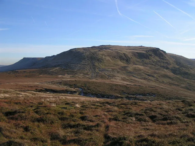
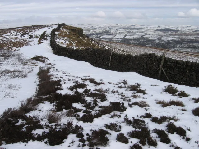
The Edge — mountain in england east midlands. Elevation: 631 m.

Anthony Parkes — CC BY-SA 2.0 via Wikimedia Commons licence
Plan your visit
- Typical visit
- 3 h–8 h
- Best time of year
- Late spring – early autumn (May–Oct)
About
The Edge is a mountain located in england east midlands. Elevation: 631 m. A named British peak recorded in OpenStreetMap. Peaks are typically named on Ordnance Survey 1:50k mapping.
Photo gallery
Place summary
The Edge is a mountain located in the East Midlands. It is known for its rugged terrain and scenic views, making it a notable feature in the region. Visitors can expect various outdoor activities, including hiking and climbing, suitable for different skill levels. The area is popular among both casual walkers and experienced adventurers looking to explore the natural landscape.
AI-generated from the structured facts on this page (operator, designation, listing, era). Not a substitute for visiting.
- Coordinates
- 53.4011, -1.8857
Sources
- osm: n1445727565 (ODbL)
Other places nearby
Loading nearby places…
Nearby
 📷 5
📷 5Waterfalls · East Midlands
Kinder Downfall
Kinder Downfall — waterfall in england east midlands.
 📷 5
📷 5Wild swimming spots · East Midlands
Mermaid's pool
Mermaid's pool — a wild swimming in england east midlands.
 📷 3
📷 3Memorials & monuments · East Midlands
Memorial to Flying Officer James Desmond Horne
Memorial to Flying Officer James Desmond Horne — a memorial in england-east-midlands, United Kingdom.
 📷 4
📷 4Mountains & hills · East Midlands
Mill Hill
Mill Hill — Named summit at 544 m.
 📷 5
📷 5Mountains & hills · East Midlands
Kinder Scout
Kinder Scout — Named summit at 636 m.
 Flagship📷 5
National parks · East Midlands
Peak District
Peak District is a Upland area in England.
Where to eat & stay near The Edge
Places to stay
 📷 5
📷 5Campsites · East Midlands
Hayfield Campsite
Hayfield Campsite — a campsite in england east midlands.
 📷 5
📷 5Campsites · East Midlands
Upper Booth Farm Campsite
Upper Booth Farm Campsite — a campsite in england east midlands.
 📷 5
📷 5Hotels · East Midlands
Kinder Lodge
Kinder Lodge — a hotel in england east midlands.
 📷 5
📷 5Campsites · East Midlands
Whitmore Lea Campsite
Whitmore Lea Campsite — a campsite in england east midlands.
 📷 5
📷 5Campsites · East Midlands
chapel view campsite
chapel view campsite — a campsite in england east midlands.
 📷 5
📷 5Campsites · East Midlands
Newfold Farm Campsite
Newfold Farm Campsite — a campsite in england east midlands.
Places to eat & drink
 📷 5
📷 5Historic pubs · Yorkshire & the Humber
Royal Hotel
Royal Hotel in England Yorkshire, United Kingdom.
 📷 5
📷 5Historic pubs · Yorkshire & the Humber
The Old Nags Head
The Old Nags Head in England Yorkshire, United Kingdom.
 📷 5
📷 5Historic pubs · Yorkshire & the Humber
The Crown Inn, Glossop
The Crown Inn, Glossop in England Yorkshire, United Kingdom.
 📷 5
📷 5Historic pubs · Yorkshire & the Humber
Former Dollars Public House
Former Dollars Public House in England Yorkshire, United Kingdom.
 📷 5
📷 5Historic pubs · Yorkshire & the Humber
Norfolk Arms Public House
Norfolk Arms Public House in England Yorkshire, United Kingdom.
 📷 5
📷 5Historic pubs · Yorkshire & the Humber
The Oakwood and Oakwood Restaurant
The Oakwood and Oakwood Restaurant in England Yorkshire, United Kingdom.
More mountains in this region
 📷 3
📷 3Mountains & hills · East Midlands
Axe Edge Moor
Axe Edge Moor — Named summit at 551 m.
Mountains & hills · East Midlands
Beacon Hill
Beacon Hill — Named summit at 244.5 m.
Mountains & hills · East Midlands
Beacon Hill
Beacon Hill — Named summit at 105 m.
 📷 3
📷 3Mountains & hills · East Midlands
Black Edge - Summit
Black Edge - Summit — Named summit at 506.7 m.
Frequently asked questions
- Where is The Edge?
- The Edge is in the East Midlands, United Kingdom.
- What is The Edge?
- The Edge — mountain in england east midlands. Elevation: 631 m.
- How do I get to The Edge?
- Its coordinates are 53.4011°, -1.8857°.