Mountains & hills · Scottish Lowlands
Tarnmonath Fell
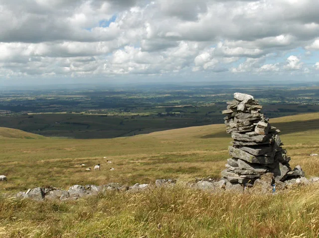
Tarnmonath Fell — mountain in scotland lowlands. Elevation: 512 m.

Mick Garratt — CC BY-SA 2.0 via Wikimedia Commons licence
Plan your visit
- Typical visit
- 3 h–8 h
- Best time of year
- Late spring – early autumn (May–Oct)
About
Tarnmonath Fell is a mountain located in scotland lowlands. Elevation: 512 m. A named British peak recorded in OpenStreetMap. Peaks are typically named on Ordnance Survey 1:50k mapping.
Photo gallery
Place summary
Tarnmonath Fell is a mountain located in the Scottish Lowlands. This area is characterised by rolling hills and scenic landscapes, offering a range of outdoor activities. Visitors can expect walking trails that showcase the natural beauty of the region. The mountain is a notable feature of the local geography, appealing to hikers and nature enthusiasts.
AI-generated from the structured facts on this page (operator, designation, listing, era). Not a substitute for visiting.
- Coordinates
- 54.8842, -2.6454
Sources
- osm: n5151649223 (ODbL)
Other places nearby
Loading nearby places…
Nearby
 📷 4
📷 4Castles · North East England
Castle Carrock
Castle Carrock in England North East, United Kingdom.
 📷 5
📷 5Mountains & hills · Scottish Lowlands
Simmerson Hill
Simmerson Hill — a hill or mountain in scotland lowlands.
📷 5Mountains & hills · Scottish Lowlands
Simmerson Hill
Simmerson Hill — mountain in scotland lowlands. Elevation: 400 m.
 📷 4
📷 4Castles · North East England
Geltsdale
Geltsdale in England North East, United Kingdom.
 📷 3
📷 3Natural landmarks · Scottish Lowlands
Cold Fell
Cold Fell — mountain in Cumbria, England, UK.
 📷 3
📷 3Mountains & hills · Scottish Lowlands
Cold Fell
Cold Fell — Named summit at 621 m.
Where to eat & stay near Tarnmonath Fell
Places to stay
 📷 5
📷 5Caravan parks · Scottish Lowlands
Chapel House Caravan Park
Chapel House Caravan Park — a caravan park in scotland lowlands.
 📷 5
📷 5Hotels · Scottish Lowlands
Farlam Hall
Farlam Hall — a hotel in scotland lowlands.
 📷 5
📷 5Campsites · Scottish Lowlands
Talkin Tarn Campsite
Talkin Tarn Campsite — a campsite in scotland lowlands.
 📷 5
📷 5Caravan parks · Scottish Lowlands
Cleugh Head Caravan Club
Cleugh Head Caravan Club — a caravan park in scotland lowlands.
 📷 5
📷 5Hotels · Scottish Lowlands
White Lion
White Lion — a hotel in scotland lowlands.
 📷 5
📷 5B&Bs · Scottish Lowlands
Scotch Arms Mews
Scotch Arms Mews — a bed-and-breakfast in scotland lowlands.
Places to eat & drink
 📷 4
📷 4Historic pubs · North East England
Hallbankgate
Hallbankgate in England North East, United Kingdom.
 📷 5
📷 5Historic pubs · Scottish Lowlands
Graham Arms (West Of Gelt Bridge)
Graham Arms (West Of Gelt Bridge) in Scotland Lowlands, United Kingdom.
 📷 4
📷 4Historic pubs · North East England
Kingwater
Kingwater in England North East, United Kingdom.
 📷 5
📷 5Historic pubs · Scottish Lowlands
St Nicholas Arms Public House
St Nicholas Arms Public House in Scotland Lowlands, United Kingdom.
 📷 5
📷 5Historic pubs · Scottish Lowlands
The Andalusian
The Andalusian in Scotland Lowlands, United Kingdom.
 📷 3
📷 3Historic pubs · Scottish Lowlands
The Griffin
The Griffin — Historic pub — listed building or notable heritage status.
More mountains in this region
 📷 3
📷 3Mountains & hills · Scottish Lowlands
Andrewhinney Hill
Andrewhinney Hill — Named summit at 677 m.
 📷 3
📷 3Mountains & hills · Scottish Lowlands
Arbory Hill
Arbory Hill — Named summit at 429 m.
 📷 3
📷 3Mountains & hills · Scottish Lowlands
Auchenton Hill ( East Mount Lowther)
Auchenton Hill ( East Mount Lowther) — Named summit at 631 m.
 📷 3
📷 3Mountains & hills · Scottish Lowlands
Bakestall
Bakestall — Named summit at 673.5 m.
Frequently asked questions
- Where is Tarnmonath Fell?
- Tarnmonath Fell is in the Scottish Lowlands, United Kingdom.
- What is Tarnmonath Fell?
- Tarnmonath Fell — mountain in scotland lowlands. Elevation: 512 m.
- How do I get to Tarnmonath Fell?
- Its coordinates are 54.8842°, -2.6454°.