Mountains & hills · Northern Ireland
Slieve Croob
Also known as: Sliabh Crúibe
In or near Dromara.
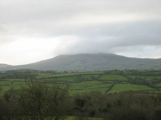
Slieve Croob — Named summit at 534 m.

Wikimedia Commons contributors — see linked file page for photographer and licence licence
Plan your visit
- Typical visit
- 3 h–8 h
- Best time of year
- Late spring – early autumn (May–Oct)
- Free entry
- Dog-friendly
About
Slieve Croob is a named summit in the United Kingdom. Also known as: Sliabh Crúibe. Wikidata describes it as: "Named summit at 534 m.". Coordinates: 54.3401°, -5.9734°.
Photo gallery
From the Wikipedia article
Slieve Croob (from Irish Sliabh Crúibe 'mountain of the hoof') is a mountain with a height of 534 metres (1,752 ft) in the middle of County Down, Northern Ireland. It is the heart of a mountainous area, the Dromara Hills, north of the Mourne Mountains. It is designated an Area of Outstanding Natural Beauty and is the source of the River Lagan. There is a small road to the summit, where there is an ancient burial cairn and several transmitter stations with radio masts. It has wide views over all of County Down and further afield. The Dromara Hills also includes Slievenisky, Cratlieve, Slievegarran and Slievenaboley. Slieve Croob may have been the mountain named Brí Erigi or Brí Airige in medieval writings. The cairn on its summit is believed to be the remains of an ancient burial mound, possibly of a passage tomb like the one on Slieve Gullion. In the 19th century it was recorded to be 77 yards (70 m) around and 18 yards (16 m) in "conical height", with forty-two "pillar stones" or kerbstones around the edge. The cairn would have had a well-defined shape when it was built. Still, over time it has slipped and been damaged by visitors. Irish folklore holds that it is bad luck to damage such cairns. Some of its stones have been piled into smaller cairns on top of it, which led to the summit being nicknamed 'The Twelve Cairns'. Traditionally, people would gather on the summit at Lughnasadh where they would add a stone to one of the cairns. They would collect and eat bilberries and there would be folk music, dancing and games. Local people still climb the mountain on the first Sunday in August (referred to as Cairn Sunday or Blaeberry Sunday), and carry a stone up the mountain to help bury the twelve Kings, who are said to be buried at the top. Legannany Dolmen sits on the southern slopes of Slieve Croob near the village of Leitrim.
Excerpt from Wikipedia under CC BY-SA 4.0. See the source article linked in Sources below.
- Coordinates
- 54.3401, -5.9734
- District
- Newry, Mourne and Down
- Postcode
- BT24 8QS
- Parliamentary constituency
- South Down
Sources
- osm: n332372936 (ODbL)
- wikipedia: Slieve Croob (CC BY-SA 4.0)
- commons: Slieve Croob - geograph.org.uk - 87690.jpg (CC BY-SA 4.0)
Other places nearby
Slieve Croob
Natural landmarks · 0.0 km

River Lagan
Natural landmarks · 0.6 km

Sliabh an Uisce
Mountains & hills · 1.1 km
Slievenisky
Mountains & hills · 1.1 km
Crocknafoyle
Mountains & hills · 1.3 km

Treetop Trail
Mountain bike trails · 1.5 km

Slieve Croob Camping
Campsites · 1.7 km

Source of the River Lagan
Public art & sculpture · 1.8 km
Drumkeeragh Forest
Archaeological sites · 2.2 km

Cratlieve
Mountains & hills · 2.4 km
Cratlieve
Mountains & hills · 2.4 km

Legananny Cross Stone
Memorials & monuments · 3.0 km
Nearby
📷 4📷 5Natural landmarks · Northern Ireland
River Lagan
River Lagan in Northern Ireland, United Kingdom.
📷 5Mountains & hills · Northern Ireland
Sliabh an Uisce
Sliabh an Uisce — a hill or mountain in northern ireland.
📷 5Mountains & hills · Northern Ireland
Slievenisky
Slievenisky — mountain in northern ireland. Elevation: 446 m.
📷 5Mountains & hills · Northern Ireland
Crocknafoyle
Crocknafoyle — mountain in northern ireland. Elevation: 350 m.
📷 5Mountain bike trails · Northern Ireland
Treetop Trail
Treetop Trail — a mtb trail in northern ireland.
Where to eat & stay near Slieve Croob
Places to stay
📷 5Campsites · Northern Ireland
Slieve Croob Camping
Slieve Croob Camping — a campsite in northern ireland.
 📷 5
📷 5Campsites · Northern Ireland
Castlewellan Touring-in-the-Trees
Castlewellan Touring-in-the-Trees — a campsite in northern ireland.
 📷 5
📷 5Campsites · Northern Ireland
Castlewellan Forest Park - Camping
Castlewellan Forest Park - Camping — a campsite in northern ireland.
 📷 5
📷 5Caravan parks · Northern Ireland
Castlewellan Forest Park - Caravan Site
Castlewellan Forest Park - Caravan Site — a caravan park in northern ireland.
 📷 5
📷 5Campsites · Northern Ireland
Tollymore Forest Park - Campsite
Tollymore Forest Park - Campsite — a campsite in northern ireland.
 📷 5
📷 5Caravan parks · Northern Ireland
Tollymore Forest
Tollymore Forest — a caravan park in northern ireland.
Places to eat & drink
 📷 3
📷 3Historic pubs · Northern Ireland
Soma Festival
The Soma Festival (Sanskrit: सोम, or sóma, meaning drink of the Gods, see Soma (drink); Irish: Féile Soma) is an annual music, arts, and cultural festival. The festival includes concerts, musical perf
More mountains in this region
 📷 5
📷 5Mountains & hills · Northern Ireland
Belfast Lough
Belfast Lough — intertidal inlet in Northern Ireland.
 📷 5
📷 5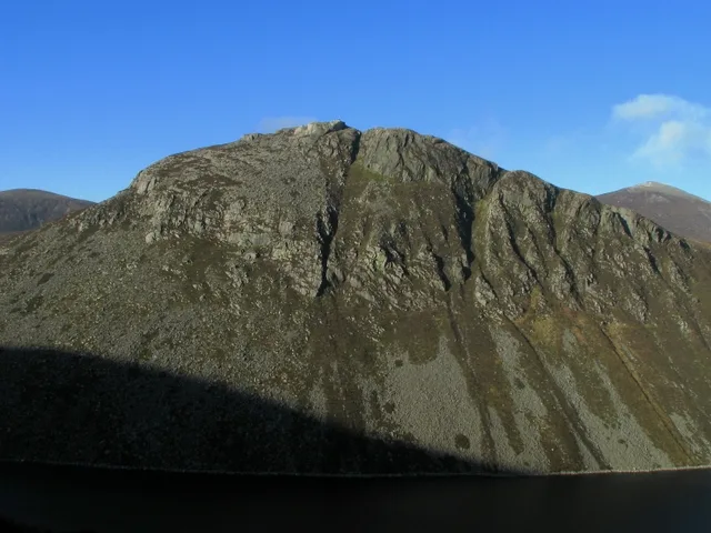 📷 4
📷 4 📷 3
📷 3Mountains & hills · Northern Ireland
Benbradagh
Benbradagh — Named summit at 465 m.
Frequently asked questions
- Where is Slieve Croob?
- Slieve Croob is in Northern Ireland, United Kingdom (postcode BT24 8QS).
- What is Slieve Croob?
- Slieve Croob — Named summit at 534 m.
- How do I get to Slieve Croob?
- Drivers can use postcode BT24 8QS.
- Is Slieve Croob free to visit?
- Yes, Slieve Croob is free to enter.
- How do I get to Slieve Croob?
- Drivers can navigate to postcode BT24 8QS. It sits within the South Down parliamentary constituency.