
Archaeological sites · North East England
Morpeth
Also known as: Morpeth, Northumberland
In or near Mitford.
Morpeth in England North East, United Kingdom.

Geoff Holland — CC BY-SA 2.0 via Wikimedia Commons licence

Plan your visit
- Typical visit
- 45 min–1.5 h
- Nearest railway station
- Morpeth · 0.8 km
- Free entry
- Dog-friendly
Getting there & planning your visit
To visit Morpeth, the nearest railway station is Morpeth, located 0.8 km away. Entry is free, and the postcode for sat-nav is NE61 1PY.
About
Morpeth is a place of interest in England North East, United Kingdom — drawn from open-data sources for visitor reference. See the linked Wikipedia article for the full description.
Photo gallery
See it from the streetimagery from 2025
Imagery © Mapillary contributors, CC BY-SA 4.0
Official information
Northumberland Escape Rooms in Morpeth offers immersive live escape games where teams solve puzzles to escape themed rooms within 60 minutes. The venue features unique games like 'The Matter of the Hatter' and 'Murder on the Morpeth Express', suitable for families, friends, and corporate events.
Protected designations
- Site of Special Scientific Interest: Northumberland Shore SSSI
Designations sourced from Natural England open data under OGL v3.
From the Wikipedia article
Morpeth is a historic market town in Northumberland, England, lying on the River Wansbeck. Nearby towns include Ashington and Bedlington. In the 2011 census, the population of Morpeth was given as 14,017, up from 13,833 in the 2001 census. The earliest evidence of settlement is believed to be from the Neolithic period, and some Roman artifacts have also been found. The first written mention of the town is from 1080, when the de Merlay family was granted the barony of Morpeth. The meaning of the town's name is uncertain, but it may refer to its position on the road to Scotland and a murder which occurred on that road. The de Merlay family built two castles in the town in the late 11th century and the 13th century. The town was granted its coat of arms in 1552. By the mid-1700s it had become one of the main markets in England, having been granted a market charter in 1200, but the opening of the railways in the 1800s led the market to decline. The town's history is celebrated in the annual Northumbrian Gathering. Morpeth is governed by Northumberland County Council and Morpeth Town Council. The town is split into three wards – North, Kirkhill and Stobhill – for the purposes of parish elections. In 2008, the town suffered a severe flood, which was repeated in 2012, resulting in the construction of new flood defences. Morpeth railway station is on the east coast line and a curve to the south of it has caused several rail crashes. Several sports teams compete in Morpeth, with Morpeth Town A.F.C. having been the winner of the FA Vase in 2016. The town hosted its own Olympics from 1873 to 1958. Two middle schools, a high school and seven first schools are situated in Morpeth, as well as several churches of Anglican, Roman Catholic, United Reformed and Methodist denominations. Morpeth's Carlisle Park, the recipient of several awards, contains one of the four floral clocks in England.
Excerpt from Wikipedia under CC BY-SA 4.0. See the source article linked in Sources below.
Background
History
Morpeth was founded at a crossing point of the River Wansbeck. Remains from prehistory are scarce, but the earliest evidence of occupation found is a stone axe thought to be from the Neolithic period. There is a lack of evidence of activity during the Roman occupation of Britain, although there were probably settlements in the area at that time. The name derives from Old English morð pæð and literally means "murder path"; writing in 1666, the antiquarian John Stainsby attributed this moniker to "the many robberies and murders in those parts committed". The barony of Morpeth was granted to the de Merlay family in around 1080, and by 1095 a motte-and-bailey castle had been built by William de…
Sourced from Wikipedia under CC BY-SA 4.0.
- Coordinates
- 55.1675, -1.6908
- District
- Northumberland
- Parish
- Morpeth
- Postcode
- NE61 1PY
- Parliamentary constituency
- North Northumberland
- Phone
- +441670 631439
- Nearest railway station
- Morpeth — 0.8 km
Sources
- wikidata: Q736785 (CC0)
- wikipedia: Morpeth, Northumberland (CC BY-SA 4.0)
Featured in these 2 guides
Other places nearby
Morpeth Clock Tower
Historic houses · 0.0 km
Northumberland Escape Rooms Morpeth
Escape rooms · 0.0 km

The Town Hall
Historic houses · 0.0 km

Micah's Tea Rooms
Cafés · 0.1 km
.jpg?width=1200)
Collingwood House
Historic houses · 0.1 km

Roman Catholic Church of St Robert
Cathedrals · 0.1 km
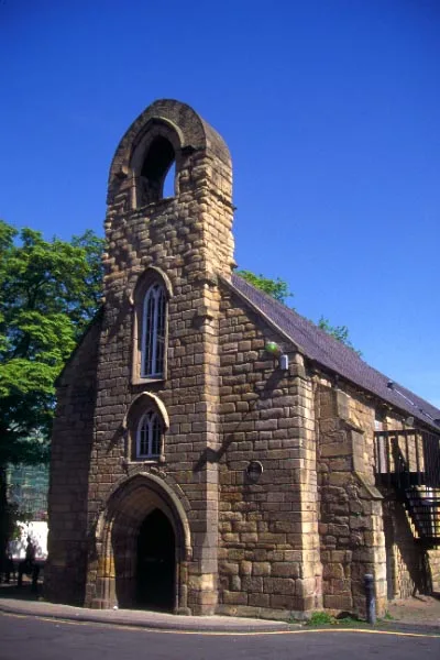
Morpeth Chantry
Historic churches · 0.3 km
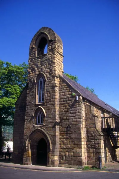
Morpeth Chantry Bagpipe Museum
Museums · 0.3 km

St James the Great, Morpeth
Cemeteries · 0.3 km

Telford Bridge
Historic bridges · 0.3 km
_63.jpg?width=1200)
Ha' Hill
Viewpoints · 0.4 km

Haw Hill
Castles · 0.4 km
Nearby
📷 4Historic houses · North East England
Morpeth Clock Tower
Morpeth Clock Tower in England North East, United Kingdom.
📷 3Escape rooms · North East England
Northumberland Escape Rooms Morpeth
Northumberland Escape Rooms Morpeth — a escape room in scotland-lowlands, United Kingdom.
📷 4Historic houses · North East England
The Town Hall
The Town Hall in England North East, United Kingdom.
📷 5📷 3Historic houses · North East England
Collingwood House
Collingwood House — house in Morpeth, Northumberland, England, UK.
📷 4Cathedrals · North East England
Roman Catholic Church of St Robert
Roman Catholic Church of St Robert in England North East, United Kingdom.
Where to eat & stay near Morpeth
Places to stay
 📷 5
📷 5Campsites · North East England
Tranwell Farm Camp Site
Tranwell Farm Camp Site — a campsite in scotland lowlands.
 📷 5
📷 5Campsites · North East England
Selby Woods Scout Campsite
Selby Woods Scout Campsite — a campsite in scotland lowlands.
 📷 5
📷 5Caravan parks · North East England
Ellington Caravan Park
Ellington Caravan Park — a caravan park in scotland lowlands.
 📷 5
📷 5 📷 5
📷 5Caravan parks · North East England
Felmoor Park
Felmoor Park — a caravan park in scotland lowlands.
 📷 5
📷 5Places to eat & drink
📷 5 📷 5
📷 5Historic pubs · North East England
The Seven Stars Public House
The Seven Stars Public House in Scotland Lowlands, United Kingdom.
 📷 5
📷 5Historic pubs · North East England
The Anglers Arms
The Anglers Arms in Scotland Lowlands, United Kingdom.
 📷 5
📷 5Historic pubs · North East England
Northumberland Arms
Northumberland Arms in Scotland Lowlands, United Kingdom.
 📷 5
📷 5Historic pubs · North East England
Border Minstrel
Border Minstrel in Scotland Lowlands, United Kingdom.
 📷 3
📷 3Historic pubs · North East England
Red House Farm
Red House Farm in England North East, United Kingdom.
More archaeological sites in this region
 📷 5
📷 5Archaeological sites · North East England
Medieval Manorial Site of Low Dinsdale
Medieval Manorial Site of Low Dinsdale — archaeological in england yorkshire.
 📷 3
📷 3Archaeological sites · North East England
Old Smelting Mill
Old Smelting Mill — an archaeological site in North East England, United Kingdom.
 📷 5
📷 5Archaeological sites · North East England
Roper Castle or Round Table (Roman Signal Station)
Roper Castle or Round Table (Roman Signal Station) — archaeological in england north west.
 📷 5
📷 5Archaeological sites · North East England
Nine Standards Rigg
Nine Standards Rigg — archaeological in england north west. Elevation: 662 m.
Frequently asked questions
- Where is Morpeth?
- Morpeth is in North-East England, United Kingdom (postcode NE61 1PY), in the parish of Morpeth.
- What is Morpeth?
- Morpeth in England North East, United Kingdom.
- How do I get to Morpeth?
- The nearest railway station is Morpeth, about 0.8 km away. The nearest town is Mitford. Drivers can use postcode NE61 1PY.
- Is Morpeth a protected site?
- Yes — Morpeth is part of the Northumberland Shore SSSI Site of Special Scientific Interest.
- Is Morpeth free to visit?
- Yes, Morpeth is free to enter.
- How do I get to Morpeth?
- The nearest railway station is Morpeth, about 0.8 km away. Drivers can navigate to postcode NE61 1PY.