
Natural landmarks · North East England
Mickle Fell
In or near Helbeck.
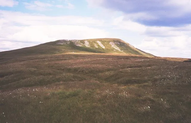
Mickle Fell — fell in County Durham. United Kingdom.

Wikimedia Commons contributors — see linked file page for photographer and licence licence

Plan your visit
- Typical visit
- 1 h–2 h
- Free entry
- Dog-friendly
About
Mickle Fell is a named natural landmark in the United Kingdom. Constructed primarily of limestone. Wikidata describes it as: "fell in County Durham. United Kingdom". Coordinates: 54.6135°, -2.3050°.
Photo gallery
Protected designations
- Site of Special Scientific Interest: Lune Forest SSSI
- Site of Special Scientific Interest: Upper Teesdale SSSI
- Site of Special Scientific Interest: Appleby Fells SSSI
- Site of Special Scientific Interest: River Eden and Tributaries SSSI
Designations sourced from Natural England open data under OGL v3.
From the Wikipedia article
Mickle Fell is a mountain in the Pennines, the range of hills and moors running down the middle of Northern England. It has a maximum elevation of 788 m (2,585 ft). It lies slightly off the main watershed of the Pennines, about 10 miles (16 kilometres) south of Cross Fell. After Cross Fell, Mickle Fell is the highest Marilyn within the North Pennines designated Area of Outstanding Natural Beauty (AONB). It is the highest point within the historic county of Yorkshire. It is part of southern Teesdale, which was transferred from the North Riding of Yorkshire to County Durham for administrative and ceremonial purposes under the Local Government Act 1972 (taking effect in 1974). It is thus also the highest point within the current unitary council area of Durham. The highest point in historic County Durham is Burnhope Seat between Teesdale and Weardale. The name of Mickle Fell comes from the Old Norse word mikill meaning great and fell (or fjall) meaning mountain or hill. The fell lies in the middle of a large area of boggy moorland and requires a long hike to get to it from any direction. Mickle Fell's distinctive outline makes it a recognisable object in views from the Lake District hills, particularly Blencathra, the Helvellyn range, and High Street. South of Mickle Fell the ridge descends to the Stainmore Gap before rising again into the Yorkshire Dales. Mickle Fell and surrounding moorland forms part of the Warcop Training Area, a Ministry of Defence firing range. As a result, public access to the fell is limited and it is not visited by hillwalkers as often as other well-known summits in Yorkshire, despite its importance. It can be ascended from the Eden Valley to the west, or from Teesdale to the east. Marilyns are rare in the North Pennines because of the relative flatness of the moors, but Mickle Fell is one such hill: it is separated from its neighbours by over 200 m of relative height.
Excerpt from Wikipedia under CC BY-SA 4.0. See the source article linked in Sources below.
Background
Visiting
Mickle Fell and surrounding moorland forms part of the Warcop Training Area, a Ministry of Defence firing range. As a result, public access to the fell is limited and it is not visited by hillwalkers as often as other well-known summits, despite its importance. It can be ascended from the Eden Valley to the west, or from Teesdale to the east.
Sourced from Wikipedia under CC BY-SA 4.0.
- Coordinates
- 54.6135, -2.3050
- Address
- Chichester |publisher= Summersdale |isbn= 978-1-84-953239-6 |pages= 256–263}}</ref>
Sources
- wikidata: Q1140310 (CC0)
- wikipedia: Mickle Fell (CC BY-SA 4.0)
- commons: Mickle Fell - geograph.org.uk - 19150.jpg (CC BY-SA 4.0)
Other places nearby
Mickle Fell
Mountains & hills · 0.3 km

Mickle Fell
Mountains & hills · 1.5 km
The Force
Waterfalls · 1.7 km

Hilton Fell
Mountains & hills · 2.9 km

Maizebeck Force
Waterfalls · 3.0 km

Little Fell
Mountains & hills · 3.0 km
Little Fell
Mountains & hills · 3.1 km

Burton Fell
Mountains & hills · 4.0 km

Rasp Hill
Mountains & hills · 4.2 km

Thistly Hill
Mountains & hills · 4.3 km

Caldron Snout
Waterfalls · 4.3 km

Hillbeck Fell
Mountains & hills · 4.4 km
Nearby
📷 5📷 5Mountains & hills · North East England
Mickle Fell
Mickle Fell — a hill or mountain in scotland lowlands.
📷 5📷 3Mountains & hills · North East England
Hilton Fell
Hilton Fell — a mountain in england-north-east, United Kingdom.
📷 5📷 5Mountains & hills · North East England
Little Fell
Little Fell — mountain in england north east. Elevation: 748 m.
Where to eat & stay near Mickle Fell
Places to stay
 📷 5
📷 5Hostels · North East England
Langdon Beck Youth Hostel
Langdon Beck Youth Hostel — a hostel in england north east. Brand: Youth Hostels Association.
 📷 5
📷 5Hostels · North East England
Langdon Beck Youth Hostel
Langdon Beck Youth Hostel — a hostel in scotland lowlands.
 📷 5
📷 5Hotels · North East England
Augill Castle
Augill Castle — a hotel in england north east.
 📷 6
📷 6B&Bs · North East England
Brow Farm
Brow Farm — a bed-and-breakfast in scotland lowlands.
 📷 5
📷 5Caravan parks · North East England
Grandie Caravan Park
Grandie Caravan Park — a caravan park in scotland lowlands.
Places to eat & drink
 📷 5
📷 5Historic pubs · North East England
1, Scattergate
1, Scattergate in England North East, United Kingdom.
 📷 7
📷 7Cafés · North West England
The White Hare Cafe
The White Hare Cafe — a café in england north west.
 📷 5
📷 5More natural landmarks in this region
 📷 4
📷 4Natural landmarks · North East England
Cleveland Way
109-mile horseshoe trail around the North York Moors and its sea cliffs.
 📷 3
📷 3Natural landmarks · North East England
The Hand Stone
The Hand Stone — a place in North East England, United Kingdom.
 📷 3
📷 3Natural landmarks · North East England
The Face Stone
The Face Stone — a place in North East England, United Kingdom.
 📷 3
📷 3Frequently asked questions
- Where is Mickle Fell?
- Mickle Fell is in North-East England, United Kingdom.
- What is Mickle Fell?
- Mickle Fell — fell in County Durham. United Kingdom.
- How do I get to Mickle Fell?
- The nearest town is Helbeck. Its coordinates are 54.6135°, -2.3050°.
- Is Mickle Fell a protected site?
- Yes — Mickle Fell is part of the Lune Forest SSSI Site of Special Scientific Interest and the Upper Teesdale SSSI Site of Special Scientific Interest.
- Is Mickle Fell free to visit?
- Yes, Mickle Fell is free to enter.