
Other places · North East England
Ingleby Greenhow
In or near Great Broughton.
Ingleby Greenhow in England North East, United Kingdom.

Gordon Hatton — CC BY-SA 2.0 via Wikimedia Commons licence

Plan your visit
- Typical visit
- 1 h–2 h
- Nearest railway station
- Battersby · 1.2 km
Getting there & planning your visit
To visit Ingleby Greenhow, the nearest railway station is Battersby, located 1.2 km away. The postcode for navigation is TS9 6LL. Entry information is not provided, so please check ahead for details on accessibility.
About
Ingleby Greenhow is a place of interest in England North East, United Kingdom — drawn from open-data sources for visitor reference. See the linked Wikipedia article for the full description.
Photo gallery
Protected designations
- Site of Special Scientific Interest: North York Moors SSSI
Designations sourced from Natural England open data under OGL v3.
From the Wikipedia article
Ingleby Greenhow is a village and civil parish in the county of North Yorkshire, England. It is on the border of the North York Moors and 3 miles (4.8 km) south of Great Ayton. From 1974 to 2023 it was part of the Hambleton District, it is now administered by the unitary North Yorkshire Council. The parish of Ingleby Greenhow has records of a John Thomasson de Grenehow, a member of the clergy, who in 1376 "had to appear before a Commission appointed to be tried with several others for either poaching or cutting down timber, or destroying property belonging to Peter de Malo Luca the 6th, of Mulgrave Castle". The name may derive from the Saxon for Englishman's green hill. How, derived from the Old Norse word haugr, means hill or mound. Ingleby Manor was bought by a Scottish courtier David Foulis in 1608. St Andrew's Church, Ingleby Greenhow, was almost entirely rebuilt in 1741, but has a Norman chancel arch inside. In 1931, British altitude and distance records for gliders were established over the moors near here, as recounted by the novelist, pilot, and aeronautical engineer Nevil Shute in his memoir, Slide Rule. The glider, a Tern produced by Shute's company, Airspeed Ltd. was flown by a skilled German sailplane pilot, Carl Magersuppe, who had been hired by Airspeed.
Excerpt from Wikipedia under CC BY-SA 4.0. See the source article linked in Sources below.
- Coordinates
- 54.4493, -1.1046
- District
- North Yorkshire
- Parish
- Ingleby Greenhow
- Postcode
- TS9 6LL
- Parliamentary constituency
- Richmond and Northallerton
- Nearest railway station
- Battersby — 1.2 km
Sources
- wikidata: Q2736813 (CC0)
- wikipedia: Ingleby Greenhow (CC BY-SA 4.0)
Other places nearby
The Dudley Arms Public House
Historic pubs · 0.1 km

Ingleby railway station
Heritage railway stations · 0.6 km
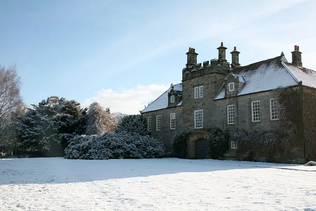
Ingleby Manor
Stately homes · 0.7 km

Battersby
Watermills · 0.9 km

Battersby railway station
Heritage railway stations · 1.1 km

Drummer Hill Farm
Historic houses · 1.7 km

Meynell Hall
Historic houses · 1.8 km

Easby Castle Hill
Castles · 2.2 km

Lawns Hill
Mountains & hills · 2.3 km

Easby Castle Motte
Literary houses · 2.3 km

Easby
Chapels · 2.3 km
Easby Hall
Historic houses · 2.4 km
Nearby
📷 4Historic pubs · North East England
The Dudley Arms Public House
The Dudley Arms Public House in England North East, United Kingdom.
📷 4Heritage railway stations · North East England
Ingleby railway station
Ingleby railway station in England North East, United Kingdom.
📷 3Stately homes · Yorkshire & the Humber
Ingleby Manor
Ingleby Manor — house in Ingleby Greenhow, North Yorkshire, England, UK.
📷 4📷 4Heritage railway stations · North East England
Battersby railway station
Battersby railway station in England North East, United Kingdom.
📷 3Historic houses · North East England
Drummer Hill Farm
Drummer Hill Farm in England North East, United Kingdom.
Where to eat & stay near Ingleby Greenhow
Places to stay
 📷 5
📷 5Campsites · Yorkshire & the Humber
Kildale Camping & Barn
Kildale Camping & Barn — a campsite in england yorkshire.
 📷 5
📷 5Caravan parks · Yorkshire & the Humber
Angrove Country Park
Angrove Country Park — a caravan park in england yorkshire.
 📷 5
📷 5Campsites · Yorkshire & the Humber
Southview Farm Campsite
Southview Farm Campsite — a campsite in england yorkshire.
 📷 5
📷 5Campsites · Yorkshire & the Humber
Lordstones Country Park
Lordstones Country Park — a campsite in england yorkshire.
 📷 5
📷 5Campsites · Yorkshire & the Humber
Holiday Lodge Park
Holiday Lodge Park — a campsite in england yorkshire.
 📷 5
📷 5Campsites · Yorkshire & the Humber
Raven Gill Campsite
Raven Gill Campsite — a campsite in england yorkshire.
Places to eat & drink
📷 4Historic pubs · North East England
The Dudley Arms Public House
The Dudley Arms Public House in England North East, United Kingdom.
 📷 5
📷 5Historic pubs · North East England
The Royal Oak Hotel
The Royal Oak Hotel in England North East, United Kingdom.
 📷 7
📷 7Historic pubs · North East England
The Queen's Head Public House
The Queen's Head Public House in England North East, United Kingdom.
 📷 5
📷 5 📷 4
📷 4Historic pubs · North East England
The Bay Horse Inn
The Bay Horse Inn in England North East, United Kingdom.
 📷 5
📷 5Historic pubs · North East England
The Stainton Public House
The Stainton Public House in England North East, United Kingdom.
More places in this region
 📷 5
📷 5Other places · North East England
Appleby Horse Fair
The Appleby Horse Fair, previously known as Appleby New Fair, is an annual gathering of Romani people (Gypsies) and Travellers in Appleby-in-Westmorland in Cumbria, England. The horse fair is held eac
 📷 5
📷 5Other places · North East England
Crosby Garrett
Crosby Garrett in England North East, United Kingdom.
 📷 5
📷 5Other places · North East England
Ravenstonedale
Ravenstonedale in England North East, United Kingdom.
 📷 5
📷 5Frequently asked questions
- Where is Ingleby Greenhow?
- Ingleby Greenhow is in North-East England, United Kingdom (postcode TS9 6LL), in the parish of Ingleby Greenhow.
- What is Ingleby Greenhow?
- Ingleby Greenhow in England North East, United Kingdom.
- How do I get to Ingleby Greenhow?
- The nearest railway station is Battersby, about 1.2 km away. Drivers can use postcode TS9 6LL.
- Is Ingleby Greenhow a protected site?
- Yes — Ingleby Greenhow is part of the North York Moors SSSI Site of Special Scientific Interest.
- How do I get to Ingleby Greenhow?
- The nearest railway station is Battersby, about 1.2 km away. Drivers can navigate to postcode TS9 6LL.