
Mountains & hills · East Midlands
Glossop Indoor Market
In or near Old Glossop.
Glossop Indoor Market is a place of interest in the United Kingdom.

Wikimedia Commons contributors — see linked file page for photographer and licence licence

Plan your visit
- Typical visit
- 3 h–8 h
- Best time of year
- Late spring – early autumn (May–Oct)
- Nearest railway station
- Glossop · 0.2 km
- Free entry
- Dog-friendly
Getting there & planning your visit
To visit Glossop Indoor Market, the nearest railway station is Glossop, located just 0.2 km away. Entry is paid, and the postcode for sat-nav is SK13 8AJ.
About
Glossop Indoor Market is a place of interest in the United Kingdom. Opening hours: Th-Sa 09:00-17:00. Coordinates: 53.4428°, -1.9498°.
Photo gallery
Summary from the official site
Glossop Indoor Market is a historic market hall that opened in 1845, originally designed to serve as a central shopping venue for the community. It features various shops and stalls, reflecting the local culture and commerce over the years. The site also includes the Town Hall, which has hosted numerous public events and meetings throughout its history.
Protected designations
- Site of Special Scientific Interest: Dark Peak SSSI
Designations sourced from Natural England open data under OGL v3.
From the Wikipedia article
Glossop Town Hall, Market Hall, and Municipal Buildings is a complex in the centre of Glossop, Derbyshire, providing offices for High Peak Borough Council, a retail arcade, and covered market. The Town Hall was constructed in 1838 and significantly extended and altered in 1845, 1897 and 1923. The Town Hall building was designed by Weightman and Hadfield of Sheffield for the 12th Duke of Norfolk. It is constructed from millstone grit ashlar and topped with a distinctive circular cupola and clock. It is Grade II listed, forming a group with the market and Municipal Buildings to the south, and rows of shops to High Street West either side which were also part of Hadfield's design, and which marked the transition of Howard Town from a satellite industrial village to a freestanding urban entity. It lies in the Norfolk Square Conservation Area which includes a number of other listed buildings around the square. The main elevation, intact with many surviving architectural details, forms an important part of the composition of the historic Norfolk Square. A blue plaque was erected by Glossop Heritage Trust in 2015 to commemorate its architect Matthew Ellison Hadfield and his contribution to the area.
Excerpt from Wikipedia under CC BY-SA 4.0. See the source article linked in Sources below.
Background
History
The town of Glossop began to develop on the junction of two roads in a fairly remote location as activity was stimulated in the 16th and 17th centuries by the expansion of the wool and cotton industries which expanded further in the 18th century by industrialisation. As the mill's trade grew, the population rose rapidly, as did demand for housing and services. The new community became known as Howardtown – named after the Lords of the Manor who were at that time the Howards, Dukes of Norfolk – and was the most populated and important township within Glossop. No elected administration existed and all communal facilities such as roads and public buildings were the responsibility of the…
Description
The building is Italianate in style The ground floor has vermiculated rustication and a central five-bay open arcade (leading to the market hall) with round arches and Tuscan Doric columns, flanked by single doorways with double doors and moulded ashlar surrounds and bracketed hoods. There is a square clock turret on the roof with a circular cupola. a function shared with Buxton Town Hall at the other end of the borough, and also as an information centre. This is in a different, more Classical, style with further use of Tuscan Doric columns, but also gables and vermiculated quoins, topped by a parapet with Vitruvian scroll motif.
Sourced from Wikipedia under CC BY-SA 4.0.
- Coordinates
- 53.4428, -1.9498
- County
- Derbyshire
- District
- High Peak
- Parish
- High Peak, unparished area
- Postcode
- SK13 8AJ
- Parliamentary constituency
- High Peak
- Established
- 1838
- Nearest railway station
- Glossop — 0.2 km
- Opening
- Th-Sa 09:00-17:00
- Official site
- web.archive.org
Sources
- osm: w201272106 (ODbL)
- wikipedia: Glossop Town Hall (CC BY-SA 4.0)
- commons: Glossop Town Hall - geograph.org.uk - 1378168.jpg (CC BY-SA 4.0)
Other places nearby

Glossop Outdoor Market
Farmers’ markets · 0.0 km

Former Dollars Public House
Historic pubs · 0.1 km

Norfolk Arms Public House
Historic pubs · 0.1 km

Glossop War Memorial
Memorials & monuments · 0.1 km

Partington Theatre
Theatres · 0.1 km
The Partington Players Theatre
Theatres · 0.1 km

The Oakwood and Oakwood Restaurant
Historic pubs · 0.2 km

Old Glossop
Towns & cities · 0.3 km
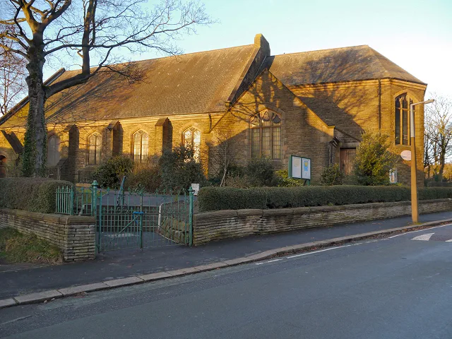
St. Luke's Church, Glossop
Historic churches · 0.4 km

The Crown Inn, Glossop
Historic pubs · 0.4 km

St Philip Howard Catholic Voluntary Academy
Historic churches · 0.5 km
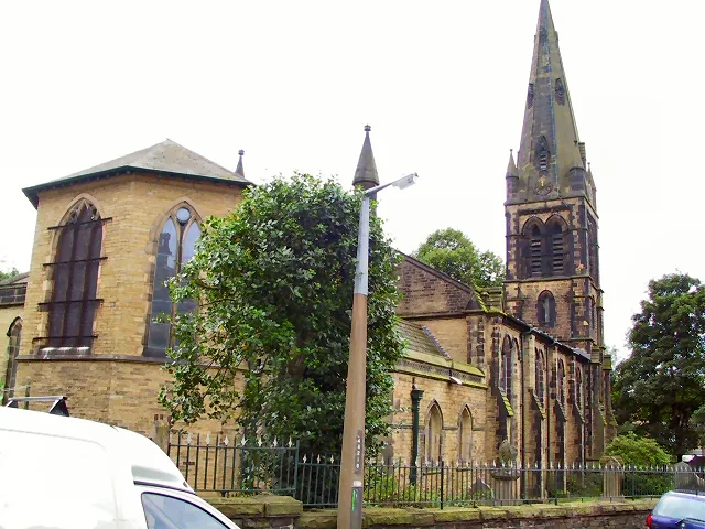
St James' Church, Glossop
Historic churches · 0.5 km
Nearby
📷 5Farmers’ markets · East Midlands
Glossop Outdoor Market
Glossop Outdoor Market — a UK farmers' market in england east midlands.
📷 5Historic pubs · East Midlands
Former Dollars Public House
Former Dollars Public House in England Yorkshire, United Kingdom.
📷 5Historic pubs · East Midlands
Norfolk Arms Public House
Norfolk Arms Public House in England Yorkshire, United Kingdom.
📷 4Memorials & monuments · East Midlands
Glossop War Memorial
Glossop War Memorial — Grade II listed building-listed memorial in england-east-midlands, United Kingdom.
📷 3Theatres · East Midlands
Partington Theatre
Partington Theatre — Grade II listed building-listed theatre in england-east-midlands, United Kingdom.
📷 3Theatres · East Midlands
The Partington Players Theatre
The Partington Players Theatre is a theatre in the United Kingdom.
Where to eat & stay near Glossop Indoor Market
Places to stay
 📷 5
📷 5Caravan parks · East Midlands
Windy Harbour Hotel Caravan and Camping Site
Windy Harbour Hotel Caravan and Camping Site — a caravan park in england east midlands.
 📷 5
📷 5Campsites · East Midlands
Crossgate Farm Campsite
Crossgate Farm Campsite — a campsite in england east midlands.
 📷 5
📷 5Campsites · Yorkshire & the Humber
Boarfold Scout Camp
Boarfold Scout Camp — a campsite in england west midlands.
 📷 5
📷 5 📷 5
📷 5Campsites · East Midlands
Crowden Campsite
Crowden Campsite — a campsite in england east midlands.
 📷 5
📷 5Hostels · East Midlands
Crowden Outdoor Education Centre
Crowden Outdoor Education Centre — a hostel in england east midlands.
Places to eat & drink
📷 5Historic pubs · East Midlands
Former Dollars Public House
Former Dollars Public House in England Yorkshire, United Kingdom.
📷 5Historic pubs · East Midlands
Norfolk Arms Public House
Norfolk Arms Public House in England Yorkshire, United Kingdom.
📷 5Historic pubs · East Midlands
The Oakwood and Oakwood Restaurant
The Oakwood and Oakwood Restaurant in England Yorkshire, United Kingdom.
📷 5Historic pubs · East Midlands
The Crown Inn, Glossop
The Crown Inn, Glossop in England Yorkshire, United Kingdom.
 📷 5
📷 5Historic pubs · East Midlands
Bulls Head Public House
Bulls Head Public House in England Yorkshire, United Kingdom.
 📷 7
📷 7Historic pubs · East Midlands
The Spinners Arms Public House
The Spinners Arms Public House in England Yorkshire, United Kingdom.
More mountains in this region
 📷 5
📷 5Mountains & hills · East Midlands
Errwood Hall
The ruin of Errwood Hall is a popular tourist destination in the scenic Upper Goyt Valley within the Peak District of England.
 📷 3
📷 3 📷 5
📷 5 📷 3
📷 3Mountains & hills · East Midlands
Black Edge - Summit
Black Edge - Summit — Named summit at 506.7 m.
Frequently asked questions
- Where is Glossop Indoor Market?
- Glossop Indoor Market is in Derbyshire, the East Midlands, United Kingdom (postcode SK13 8AJ), in the parish of High Peak, unparished area.
- What is Glossop Indoor Market?
- Glossop Indoor Market is a place of interest in the United Kingdom.
- How do I get to Glossop Indoor Market?
- The nearest railway station is Glossop, about 0.2 km away. The nearest town is Old Glossop. Drivers can use postcode SK13 8AJ.
- When was Glossop Indoor Market built?
- Built or established in 1838.
- Is Glossop Indoor Market a protected site?
- Yes — Glossop Indoor Market is part of the Dark Peak SSSI Site of Special Scientific Interest.
- Is Glossop Indoor Market free to visit?
- Yes, Glossop Indoor Market is free to enter.
- How do I get to Glossop Indoor Market?
- The nearest railway station is Glossop, about 0.2 km away. Drivers can navigate to postcode SK13 8AJ.