Mountains & hills · North West England
Border End
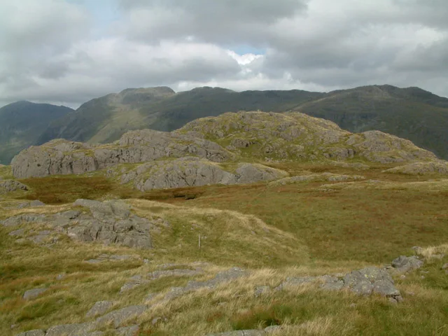
Border End — mountain in england north west. Elevation: 522 m.

Michael Graham — CC BY-SA 2.0 via Wikimedia Commons licence
Plan your visit
- Typical visit
- 3 h–8 h
- Best time of year
- Late spring – early autumn (May–Oct)
About
Border End is a mountain located in england north west. Elevation: 522 m. A named British peak recorded in OpenStreetMap. Peaks are typically named on Ordnance Survey 1:50k mapping.
Photo gallery
Place summary
Border End is a mountain located in North-West England. It is part of the Lake District National Park, known for its rugged terrain and scenic vistas. Visitors can expect a range of walking trails that cater to different abilities, providing access to the area's natural beauty. The region is characterised by its distinctive wildlife and varied landscapes, making it a notable destination for outdoor enthusiasts.
AI-generated from the structured facts on this page (operator, designation, listing, era). Not a substitute for visiting.
- Coordinates
- 54.4066, -3.1905
Sources
- osm: n2282499190 (ODbL)
Other places nearby
Loading nearby places…
Nearby
 📷 3
📷 3Natural landmarks · North West England
Eskdale Needle
Eskdale Needle — a other in england-north-west, United Kingdom.
 📷 5
📷 5Mountains & hills · North West England
Eskdale Needle
Eskdale Needle — mountain in england north west. Elevation: 468 m.
 📷 3
📷 3Mountains & hills · North West England
Hard Knott
Hard Knott — Named summit at 549.6 m.
 📷 5
📷 5Archaeological sites · North West England
Hardknott Roman Fort
Hardknott Roman Fort is an archeological site, the remains of the Roman fort Mediobogdum, located on the western side of the challenging Hardknott Pass in the English Lake District. The fort was built
 📷 5
📷 5Archaeological sites · North West England
Hardknott Roman Fort
Hardknott Roman Fort — archaeological in england north west. Operated by English Heritage.
 📷 3
📷 3Viewpoints · North West England
Hardknot Pass Viewpoint
Hardknot Pass Viewpoint is a viewpoint in the United Kingdom.
Where to eat & stay near Border End
Places to stay
 📷 5
📷 5Hostels · North West England
YHA Eskdale
YHA Eskdale — a hostel in england north west.
 📷 5
📷 5Campsites · North West England
Eskdale Campsite
Eskdale Campsite — a campsite in england north west.
 📷 5
📷 5Campsites · North West England
Turner Hall Farm Campsite
Turner Hall Farm Campsite — a campsite in england north west.
 📷 5
📷 5Hostels · North West England
YHA Coppermines
YHA Coppermines — a hostel in england north west.
 📷 5
📷 5Campsites · North West England
Great Langdale Campsite
Great Langdale Campsite — a campsite in england north west.
 📷 5
📷 5Hostels · North West England
Yorkshire Mountaineering Club Hut
Yorkshire Mountaineering Club Hut — a hostel in england north west.
Places to eat & drink
 📷 5
📷 5Historic pubs · North West England
Church House Public House
Church House Public House in England North West, United Kingdom.
 📷 5
📷 5Restaurants · North West England
The Terrace Coffee House and Restaurant
The Terrace Coffee House and Restaurant — a restaurant in england north west. Cuisine: sandwich;lunch.
 📷 5
📷 5Historic pubs · North West England
Blacksmiths Arms
Blacksmiths Arms in England North West, United Kingdom.
 📷 5
📷 5Historic pubs · North West England
The Travellers Rest
The Travellers Rest in England North West, United Kingdom.
 📷 5
📷 5Historic pubs · North West England
Sun Cottage Sun Inn Public House
Sun Cottage Sun Inn Public House in England North West, United Kingdom.
 📷 5
📷 5Historic pubs · North West England
Golden Rule Hotel
Golden Rule Hotel in England North West, United Kingdom.
More mountains in this region
 📷 3
📷 3Mountains & hills · North West England
Allen Crags
Allen Crags — Named summit at 785 m.
 📷 3
📷 3Mountains & hills · North West England
Alum Pot
Alum Pot — Open shaft pothole in North Yorkshire.
 📷 3
📷 3Mountains & hills · North West England
Arnside Knott
Arnside Knott — Named summit at 159 m.
 📷 3
📷 3Mountains & hills · North West England
Aye Gill Pike
Aye Gill Pike — Named summit at 556.3 m.
Frequently asked questions
- Where is Border End?
- Border End is in North-West England, United Kingdom.
- What is Border End?
- Border End — mountain in england north west. Elevation: 522 m.
- How do I get to Border End?
- Its coordinates are 54.4066°, -3.1905°.