Mountains & hills · Scottish Lowlands
Black Dub
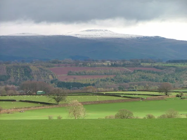
Black Dub — mountain in scotland lowlands. Elevation: 803.8 m.

Milestone Society — CC BY-SA 2.0 via Wikimedia Commons licence
Plan your visit
- Typical visit
- 3 h–8 h
- Best time of year
- Late spring – early autumn (May–Oct)
About
Black Dub is a mountain located in scotland lowlands. Elevation: 803.8 m. A named British peak recorded in OpenStreetMap. Peaks are typically named on Ordnance Survey 1:50k mapping.
Photo gallery
Place summary
Black Dub is a mountain located in the Scottish Lowlands. It is characterised by its rugged terrain and scenic views, typical of the region's landscape. Visitors can expect a variety of walking trails that cater to different skill levels, offering opportunities for outdoor activities in a natural setting. The area is known for its diverse wildlife and flora, making it a suitable destination for nature enthusiasts.
AI-generated from the structured facts on this page (operator, designation, listing, era). Not a substitute for visiting.
- Coordinates
- 54.7083, -2.4641
Sources
- osm: n433613079 (ODbL)
Other places nearby
Loading nearby places…
Nearby
 📷 5
📷 5Mountains & hills · Scottish Lowlands
Fallow Hill
Fallow Hill — mountain in scotland lowlands. Elevation: 787.3 m.
 📷 3
📷 3Natural landmarks · Scottish Lowlands
Tees Head
Tees Head — a other in scotland-lowlands, United Kingdom.
📷 4Memorials & monuments · North East England
River Tees
River Tees in England North East, United Kingdom.
 📷 5
📷 5Mountains & hills · Scottish Lowlands
Cross Fell
Cross Fell — Named summit at 893 m.
 📷 5
📷 5Mountains & hills · North East England
Pennines
Pennines in England North East, United Kingdom.
 📷 5
📷 5Natural landmarks · Scottish Lowlands
Cross Fell
Cross Fell — mountain in Cumbria, England, UK.
Where to eat & stay near Black Dub
Places to stay
 📷 5
📷 5Caravan parks · Scottish Lowlands
Silverband Caravan Park
Silverband Caravan Park — a caravan park in scotland lowlands.
 📷 5
📷 5Campsites · Scottish Lowlands
Garrigill Village Hall Camp Site
Garrigill Village Hall Camp Site — a campsite in scotland lowlands.
 📷 5
📷 5Caravan parks · Scottish Lowlands
Crossfell Caravan Park
Crossfell Caravan Park — a caravan park in scotland lowlands.
 📷 5
📷 5Caravan parks · Scottish Lowlands
Melmerby Holiday Park
Melmerby Holiday Park — a caravan park in scotland lowlands.
 📷 5
📷 5Hostels · Scottish Lowlands
Dufton Youth Hostel
Dufton Youth Hostel — a hostel in scotland lowlands.
 📷 5
📷 5B&Bs · Scottish Lowlands
Brow Farm
Brow Farm — a bed-and-breakfast in scotland lowlands.
Places to eat & drink
 📷 3
📷 3Historic pubs · North East England
Langwathby
Langwathby in England North East, United Kingdom.
 📷 5
📷 5Cafés · Scottish Lowlands
Narrowbar Cafe
Narrowbar Cafe — a café in scotland lowlands.
 📷 5
📷 5Historic pubs · North East England
Whitfield
Whitfield in England North East, United Kingdom.
More mountains in this region
 📷 3
📷 3Mountains & hills · Scottish Lowlands
Andrewhinney Hill
Andrewhinney Hill — Named summit at 677 m.
 📷 3
📷 3Mountains & hills · Scottish Lowlands
Arbory Hill
Arbory Hill — Named summit at 429 m.
 📷 3
📷 3Mountains & hills · Scottish Lowlands
Auchenton Hill ( East Mount Lowther)
Auchenton Hill ( East Mount Lowther) — Named summit at 631 m.
 📷 3
📷 3Mountains & hills · Scottish Lowlands
Bakestall
Bakestall — Named summit at 673.5 m.
Frequently asked questions
- Where is Black Dub?
- Black Dub is in the Scottish Lowlands, United Kingdom.
- What is Black Dub?
- Black Dub — mountain in scotland lowlands. Elevation: 803.8 m.
- How do I get to Black Dub?
- Its coordinates are 54.7083°, -2.4641°.