
Mountains & hills · North East England
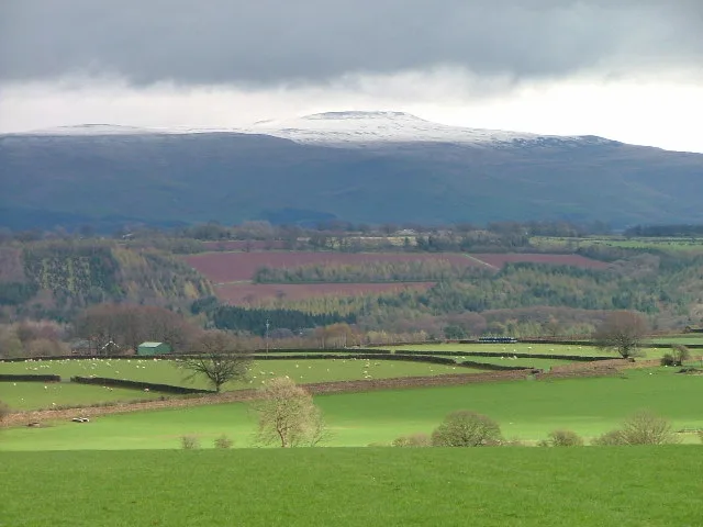
Cross Fell
In or near Ousby.
Cross Fell — Named summit at 893 m.

Wikimedia Commons contributors — see linked file page for photographer and licence licence

Plan your visit
- Typical visit
- 3 h–8 h
- Best time of year
- Late spring – early autumn (May–Oct)
- Free entry
- Dog-friendly
About
Cross Fell is a named summit in the United Kingdom. Wikidata describes it as: "Named summit at 893 m.". Coordinates: 54.7029°, -2.4867°.
Photo gallery
See it from the streetimagery from 2022
Imagery © Mapillary contributors, CC BY-SA 4.0
Protected designations
- Site of Special Scientific Interest: River Eden and Tributaries SSSI
- Site of Special Scientific Interest: Moorhouse and Cross Fell SSSI
- National Nature Reserve: MOOR HOUSE-UPPER TEESDALE
- Area of Outstanding Natural Beauty: North Pennines
Designations sourced from Natural England open data under OGL v3.
From the Wikipedia article
Cross Fell is the highest mountain in the Pennines of Northern England and the highest point in England outside the Lake District. It is located in the North Pennines Area of Outstanding Natural Beauty. It lies within the county of Cumbria and the historic county boundaries of Cumberland. The summit, at 893 metres (2,930 ft), is a stony plateau, part of a 7+3⁄4-mile-long (12.5-kilometre) ridge running north-west to south-east, which also incorporates Little Dun Fell at 842 metres (2,762 ft) and Great Dun Fell at 848 metres (2,782 ft). The three adjoining fells form an escarpment that rises steeply above the Eden Valley on its south-western side and drops off more gently on its north-eastern side towards the South Tyne and Tees Valleys. Cross Fell summit is crowned by a cross-shaped dry-stone shelter. On a clear day there are excellent views from the summit across the Eden Valley to the mountains of the Lake District. On the northern side of Cross Fell there are also fine views across the Solway Firth to the Southern Uplands of Scotland. The fell is prone to dense hill fog and fierce winds. A shrieking noise induced by the Helm Wind is a characteristic of the locality. It can be an inhospitable place for much of the year. In ancient times it was known as "Fiends Fell" and believed to be the haunt of evil spirits. St Augustine of Canterbury is said to have blessed the hill when he arrived here on his travels so it became known as Cross Fell in the Christian tradition, although it has been speculated that the fell became known as Cross Fell ("cross" meaning "angry") because of the evil spirits. Greg's Hut is a mountain bothy approximately 3⁄4 mile (1.2 kilometres) north of the summit. This bothy is looked after by the Mountain Bothies Association. Greg's Hut is the highest mountain bothy in England, sitting on the 700-metre (2,300 ft) contour line. From 2010 to 2023 the Mountain Bothies Association refurbished the bothy, including fitting new windows, flooring, and a…
Excerpt from Wikipedia under CC BY-SA 4.0. See the source article linked in Sources below.
- Coordinates
- 54.7029, -2.4867
- Address
- North Pennines, England
Sources
- osm: n9384058418 (ODbL)
- wikipedia: Cross Fell (CC BY-SA 4.0)
- commons: Crossfell.jpg (CC BY-SA 4.0)
Other places nearby

Pennines
Mountains & hills · 0.0 km
Cross Fell
Natural landmarks · 0.0 km

Tees Head
Natural landmarks · 1.3 km
River Tees
Memorials & monuments · 1.3 km

Skirwith Hill
Mountains & hills · 1.4 km

Black Dub
Mountains & hills · 1.6 km

Fallow Hill
Mountains & hills · 1.8 km
Little Dun Fell
Mountains & hills · 2.1 km

High Cap
Mountains & hills · 2.4 km

Raehow End
Mountains & hills · 2.5 km

Green Fell
Mountains & hills · 2.6 km

Brown Hill
Mountains & hills · 2.9 km
Nearby
📷 5📷 5📷 3Natural landmarks · North East England
Tees Head
Tees Head — a other in scotland-lowlands, United Kingdom.
📷 4Memorials & monuments · North East England
River Tees
River Tees in England North East, United Kingdom.
📷 5Mountains & hills · North East England
Skirwith Hill
Skirwith Hill — mountain in scotland lowlands. Elevation: 785.8 m.
📷 5Mountains & hills · North East England
Black Dub
Black Dub — mountain in scotland lowlands. Elevation: 803.8 m.
Where to eat & stay near Cross Fell
Places to stay
 📷 5
📷 5Caravan parks · North East England
Crossfell Caravan Park
Crossfell Caravan Park — a caravan park in scotland lowlands.
 📷 5
📷 5Caravan parks · North East England
Silverband Caravan Park
Silverband Caravan Park — a caravan park in scotland lowlands.
 📷 5
📷 5Caravan parks · North East England
Melmerby Holiday Park
Melmerby Holiday Park — a caravan park in scotland lowlands.
 📷 5
📷 5Caravan parks · North West England
Melmerby Mill Holiday Caravan Park
Melmerby Mill Holiday Caravan Park — a caravan park in scotland lowlands.
 📷 5
📷 5 📷 5
📷 5Campsites · North East England
Garrigill Village Hall Camp Site
Garrigill Village Hall Camp Site — a campsite in scotland lowlands.
Places to eat & drink
 📷 3
📷 3 📷 5
📷 5Historic pubs · North East England
1, Scattergate
1, Scattergate in England North East, United Kingdom.
 📷 7
📷 7Cafés · North West England
Narrowbar Cafe
Narrowbar Cafe — a café in scotland lowlands.
 📷 7
📷 7Historic pubs · North West England
Two Lions public house and integral stables
Two Lions public house and integral stables in Scotland Lowlands, United Kingdom.
 📷 6
📷 6Historic pubs · North West England
Gloucester Arms
Gloucester Arms in Scotland Lowlands, United Kingdom.
 📷 5
📷 5Historic pubs · North West England
Horse And Farrier Inn And Stables
Horse And Farrier Inn And Stables in Scotland Lowlands, United Kingdom.
More mountains in this region
 📷 5
📷 5Mountains & hills · North East England
Danby High Moor
Danby High Moor — a hill or mountain in england yorkshire.
 📷 5
📷 5Mountains & hills · North East England
Arndale Hill
Arndale Hill — mountain in england yorkshire. Elevation: 515.7 m.
 📷 5
📷 5Mountains & hills · North East England
Peat Hill
Peat Hill — mountain in england yorkshire. Elevation: 396 m.
 📷 5
📷 5Mountains & hills · North East England
Cocker Hill
Cocker Hill — mountain in england yorkshire. Elevation: 470 m.
Frequently asked questions
- Where is Cross Fell?
- Cross Fell is in the Scottish Lowlands, United Kingdom.
- What is Cross Fell?
- Cross Fell — Named summit at 893 m.
- How do I get to Cross Fell?
- Its coordinates are 54.7029°, -2.4867°.
- Is Cross Fell a protected site?
- Yes — Cross Fell is part of the River Eden and Tributaries SSSI Site of Special Scientific Interest and the Moorhouse and Cross Fell SSSI Site of Special Scientific Interest.
- Is Cross Fell free to visit?
- Yes, Cross Fell is free to enter.