Mountains & hills · North West England
Bastifell
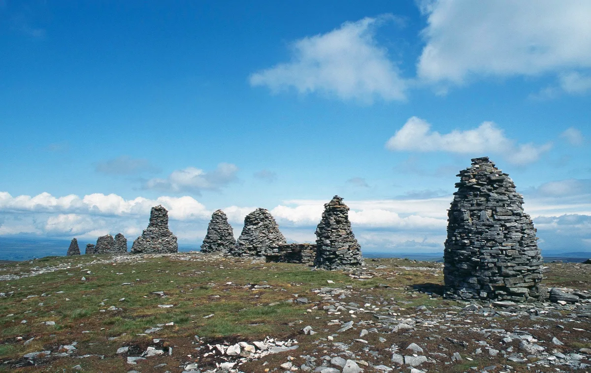
Bastifell — mountain in england north west. Elevation: 620 m.

Trevor Littlewood — CC BY-SA 2.0 via Wikimedia Commons licence
Plan your visit
- Typical visit
- 3 h–8 h
- Best time of year
- Late spring – early autumn (May–Oct)
About
Bastifell is a mountain located in england north west. Elevation: 620 m. A named British peak recorded in OpenStreetMap. Peaks are typically named on Ordnance Survey 1:50k mapping.
Photo gallery
Place summary
Bastifell is a mountain located in North-West England. It is part of the rugged landscape characteristic of this region. Visitors can expect a range of walking trails suitable for various skill levels, offering views of the surrounding countryside. The area is popular for outdoor activities such as hiking and climbing, appealing to both casual walkers and more experienced adventurers.
AI-generated from the structured facts on this page (operator, designation, listing, era). Not a substitute for visiting.
- Coordinates
- 54.4583, -2.2686
Sources
- osm: n3662662751 (ODbL)
Other places nearby
Loading nearby places…
Nearby
 📷 3
📷 3Natural landmarks · North West England
Nine Standards Rigg
Nine Standards Rigg — mountain in United Kingdom.
 📷 5
📷 5Archaeological sites · North West England
Nine Standards Rigg
Nine Standards Rigg — archaeological in england north west. Elevation: 662 m.
 📷 5
📷 5Mountains & hills · North West England
Bleatapow Hill
Bleatapow Hill — mountain in england north west. Elevation: 600 m.
📷 5Mountains & hills · North West England
Peatpot Hill
Peatpot Hill — mountain in england north west. Elevation: 580 m.
 📷 3
📷 3Mountains & hills · North West England
Nine Standards Rigg
Nine Standards Rigg — Named summit at 662 m.
 📷 5
📷 5Waterfalls · North West England
Winton Force
Winton Force — waterfall in england north west.
Where to eat & stay near Bastifell
Places to stay
 📷 5
📷 5Hostels · North West England
Kirkby Stephen Hostel
Kirkby Stephen Hostel — a hostel in england north west.
 📷 5
📷 5B&Bs · North West England
Fletcher House
Fletcher House — a bed-and-breakfast in england north west.
 📷 5
📷 5Hotels · North West England
Black Bull Hotel
Black Bull Hotel — a hotel in england north west.
 📷 5
📷 5Hotels · North West England
The Pennine Hotel
The Pennine Hotel — a hotel in england north west.
 📷 5
📷 5Campsites · North West England
Pennine View Park
Pennine View Park — a campsite in england north west.
 📷 5
📷 5Campsites · North West England
Tan Hill Inn Camping
Tan Hill Inn Camping — a campsite in england north west.
Places to eat & drink
📷 5Cafés · North West England
The White Hare Cafe
The White Hare Cafe — a café in england north west.
 📷 5
📷 5Historic pubs · North East England
Tan Hill Inn
Tan Hill Inn in England North East, United Kingdom.
 📷 5
📷 5Historic pubs · North West England
Kings Head Inn
Kings Head Inn in England North West, United Kingdom.
 📷 5
📷 5Cafés · North West England
The Cross Keys Temperance Inn
The Cross Keys Temperance Inn — a café in england north west.
 📷 5
📷 5Historic pubs · North East England
1, Scattergate
1, Scattergate in England North East, United Kingdom.
 📷 5
📷 5Historic pubs · North East England
Booze
Booze in England North East, United Kingdom.
More mountains in this region
 📷 3
📷 3Mountains & hills · North West England
Allen Crags
Allen Crags — Named summit at 785 m.
 📷 3
📷 3Mountains & hills · North West England
Alum Pot
Alum Pot — Open shaft pothole in North Yorkshire.
 📷 3
📷 3Mountains & hills · North West England
Arnside Knott
Arnside Knott — Named summit at 159 m.
 📷 3
📷 3Mountains & hills · North West England
Aye Gill Pike
Aye Gill Pike — Named summit at 556.3 m.
Frequently asked questions
- Where is Bastifell?
- Bastifell is in North-West England, United Kingdom.
- What is Bastifell?
- Bastifell — mountain in england north west. Elevation: 620 m.
- How do I get to Bastifell?
- Its coordinates are 54.4583°, -2.2686°.