
Historic houses · East of England
West Stow Hall
In or near West Stow.
West Stow Hall — a Grade I-listed historic house in england-east, United Kingdom.

Robert Edwards — CC BY-SA 2.0 via Wikimedia Commons licence

Plan your visit
- Typical visit
- 1 h–2 h
- Nearest railway station
- Bury St Edmunds · 6.8 km
- Family-friendly
- Limited wheelchair access
Getting there & planning your visit
To visit West Stow Hall, the nearest railway station is Bury St Edmunds, which is 6.8 km away. The postcode for sat-nav is IP28 6EY. Accessibility is limited for wheelchair users.
About
West Stow Hall is a Grade I-listed building in england-east, United Kingdom. Grade I status is conferred by Historic England (or Cadw, Historic Environment Scotland or NIEA equivalents) on buildings of exceptional national interest. See the linked Wikipedia article for full historical and architectural details.
Photo gallery
Protected designations
- Site of Special Scientific Interest: Lackford Lakes SSSI
- Site of Special Scientific Interest: Breckland Forest SSSI
- Site of Special Scientific Interest: Breckland Farmland SSSI
Designations sourced from Natural England open data under OGL v3.
From the Wikipedia article
West Stow Hall is a Tudor manor house in West Stow, Suffolk, England, near Bury St Edmunds. It was begun in around 1520 for Sir John Croftes, Master of the Horse to Mary Tudor.
Excerpt from Wikipedia under CC BY-SA 4.0. See the source article linked in Sources below.
Background
History
In 1526 Sir John Croftes leased the remainder of West Stow from the Abbot of Bury St Edmunds, which he purchased from the Crown after the dissolution of the Abbey for £497. The gatehouse was an independent building from the house before it was connected to the main house with a colonnade built by Sir John's grandson, in about 1580. In the 19th century restoration of the house, in a room above the entrance a wall-painting, known as the 'Four Ages of Man', was found, thought to date to around 1575. The house's original moat was filled in by 1840, and it was bridged by the gatehouse, passing under two arches beneath it, the tops of which can still be seen in the shrub border of the south side
Sourced from Wikipedia under CC BY-SA 4.0.
- Coordinates
- 52.3060, 0.6621
- County
- Suffolk
- District
- West Suffolk
- Parish
- West Stow
- Postcode
- IP28 6EY
- Parliamentary constituency
- West Suffolk
- Nearest railway station
- Bury St Edmunds — 6.8 km
- Official site
- www.historichouses.org
Sources
- wikidata: Q17526507 (CC0)
- wikipedia: West Stow Hall (CC BY-SA 4.0)
Other places nearby

West Stow Village Sign
Public art & sculpture · 0.5 km

West Stow Pods
Campsites · 0.5 km

West Stow
Towns & cities · 0.6 km

Fullers Mill Garden
Gardens · 1.0 km

Flempton
Villages · 1.0 km

The Iron Bridge At Culford School
Historic bridges · 1.3 km

Lackford Lakes
Forests & woodlands · 1.3 km
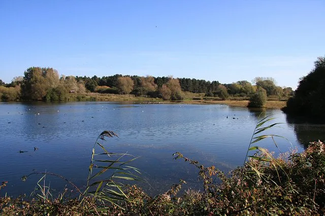
Lackford Lakes
Wildlife reserves · 1.6 km

Culford Hall
Manor houses · 1.7 km
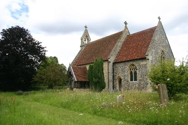
All Saints Church, Wordwell
Historic churches · 1.7 km

Flempton-cum-Hengrave War Memorial
Memorials & monuments · 1.7 km

West Stow Anglo-Saxon Museum
Museums · 1.8 km
Nearby
📷 3Public art & sculpture · East of England
West Stow Village Sign
West Stow Village Sign — a public art in england-east, United Kingdom.
📷 5📷 5Towns & cities · East of England
West Stow
West Stow — village and civil parish in Suffolk, United Kingdom.
📷 3Gardens · East of England
Fullers Mill Garden
Fullers Mill Garden — a garden in england-east, United Kingdom.
📷 5📷 5Historic bridges · East of England
The Iron Bridge At Culford School
The Iron Bridge At Culford School — a Grade I-listed bridge in england-east, United Kingdom.
Where to eat & stay near West Stow Hall
Places to stay
📷 5 📷 5
📷 5Caravan parks · East of England
King's Forest Caravan Park
King's Forest Caravan Park — a caravan park in england east.
 📷 7
📷 7 📷 5
📷 5Hotels · East of England
Angel Hotel
Angel Hotel — a hotel in england east.
 📷 7
📷 7Hotels · East of England
Chantry Hotel
Chantry Hotel — a hotel in england east.
 📷 5
📷 5Hotels · East of England
Dragonfly Hotel
Dragonfly Hotel — a hotel in england east.
Places to eat & drink
 📷 7
📷 7Historic pubs · East of England
Three Kings Public House And Attached House Stable Block
Three Kings Public House And Attached House Stable Block in England East, United Kingdom.
 📷 7
📷 7Historic pubs · East of England
The White Horse Public House Cottage And Coach House
The White Horse Public House Cottage And Coach House in England East, United Kingdom.
 📷 6
📷 6Historic pubs · East of England
The Linden Tree Public House
The Linden Tree Public House in England East, United Kingdom.
 📷 6
📷 6Historic pubs · East of England
The Bushel Public House
The Bushel Public House in England East, United Kingdom.
 📷 5
📷 5Historic pubs · East of England
The Rising Sun Public House
The Rising Sun Public House in England East, United Kingdom.
 📷 7
📷 7Historic pubs · East of England
The Market Tavern Public House
The Market Tavern Public House in England East, United Kingdom.
More historic houses in this region
 📷 5
📷 5Historic houses · East of England
41 and 41a, Broad Street
41 and 41a, Broad Street — Grade II* listed house in Ely, East Cambridgeshire, England, UK.
 📷 5
📷 5Historic houses · East of England
Abbey Gate House
Abbey Gate House — house in St Albans, Hertfordshire, England, UK.
 📷 5
📷 5Historic houses · East of England
Abbey House
Abbey House — house in Cambridge, Cambridgeshire, England, UK.
.jpg?width=1200) 📷 5
📷 5Historic houses · East of England
Amores Including Outbuildings
Amores Including Outbuildings — architectural structure in Hertford, East Hertfordshire, England, UK.
Frequently asked questions
- Where is West Stow Hall?
- West Stow Hall is in Suffolk, East of England, United Kingdom (postcode IP28 6EY), in the parish of West Stow.
- What is West Stow Hall?
- West Stow Hall — a Grade I-listed historic house in england-east, United Kingdom.
- How do I get to West Stow Hall?
- The nearest railway station is Bury St Edmunds, about 6.8 km away. The nearest town is West Stow. Drivers can use postcode IP28 6EY.
- Who owns West Stow Hall?
- West Stow Hall is owned by | designation1 = Grade I.
- Is West Stow Hall a listed building?
- West Stow Hall is officially recognised as Grade I listed.
- Is West Stow Hall a protected site?
- Yes — West Stow Hall is part of the Lackford Lakes SSSI Site of Special Scientific Interest and the Breckland Forest SSSI Site of Special Scientific Interest.
- How do I get to West Stow Hall?
- The nearest railway station is Bury St Edmunds, about 6.8 km away. Drivers can navigate to postcode IP28 6EY.