
Forests & woodlands · East of England
Lackford Lakes
In or near West Stow.
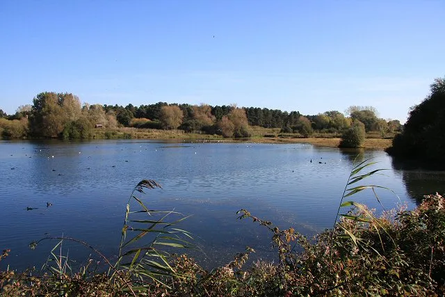
Lackford Lakes is a forest or woodland in the United Kingdom.

Wikimedia Commons contributors — see linked file page for photographer and licence licence

Plan your visit
- Typical visit
- 1 h–3 h
- Nearest railway station
- Bury St Edmunds · 7.4 km
- Free entry
- Family-friendly
- Dog-friendly
- Wheelchair accessible
Getting there & planning your visit
Lackford Lakes is located in Suffolk, with the nearest railway station being Bury St Edmunds, approximately 7.4 km away. The postcode for sat-nav is IP28 6HX, and entry to the site is free.
About
Lackford Lakes is a named forest, woodland or nature reserve in the United Kingdom. Coordinates: 52.3044°, 0.6425°. This entry is part of The Great Britain Guide, a free, ad-free, open-data tourist directory.
Photo gallery
Official information
Lackford Lakes is a nature reserve featuring lakes, reedbeds, meadows, and woodlands located near Bury St Edmunds. Visitors can enjoy a variety of wildlife throughout the year, including birds, butterflies, and dragonflies, as well as walking trails and a visitor centre.
Protected designations
- Site of Special Scientific Interest: Lackford Lakes SSSI
- Site of Special Scientific Interest: Breckland Farmland SSSI
Designations sourced from Natural England open data under OGL v3.
From the Wikipedia article
Lackford Lakes is a 105.8-hectare (261-acre) biological Site of Special Scientific Interest (SSSI) north and east of Lackford in Suffolk. The SSSI is part of the 131-hectare (320-acre) Lackford Lakes nature reserve, which is managed by the Suffolk Wildlife Trust. The lakes are disused sand and gravel pits in the valley of the River Lark. There are diverse dragonfly species, and many breeding and overwintering birds, including nationally important numbers of gadwalls and shovelers. Skylarks breed on dry grassland, and lapwings in marshy meadows. There is access from the A1101 road.
Excerpt from Wikipedia under CC BY-SA 4.0. See the source article linked in Sources below.
- Coordinates
- 52.3044, 0.6425
- County
- Suffolk
- District
- West Suffolk
- Parish
- Lackford
- Postcode
- IP28 6HX
- Parliamentary constituency
- West Suffolk
- Phone
- 01284 728706
- Nearest railway station
- Bury St Edmunds — 7.4 km
- Opening
- Daily 10am–4:30pm; Nature Reserve open dawn to dusk
- Official site
- www.suffolkwildlifetrust.org
Sources
- osm: w703010241 (ODbL)
- wikipedia: Lackford Lakes (CC BY-SA 4.0)
- commons: Lackford Lakes Nature Reserve - geograph.org.uk - 589203.jpg (CC BY-SA 4.0)
Other places nearby

Fullers Mill Garden
Gardens · 0.4 km
Lackford Lakes
Wildlife reserves · 0.5 km

West Stow Anglo Saxon Village
Archaeological sites · 0.8 km

West Stow Anglo Saxon Village
Natural landmarks · 0.8 km

West Stow Anglo-Saxon Museum
Museums · 0.9 km

Neolithic ring ditch
Archaeological sites · 0.9 km

King's Forest Caravan Park
Caravan parks · 1.1 km

Lackford Village Sign
Public art & sculpture · 1.1 km

Flempton
Villages · 1.2 km

West Stow Hall
Historic houses · 1.3 km

Lackford Manor
Manor houses · 1.4 km
Lackford
Villages · 1.4 km
Nearby
📷 3Gardens · East of England
Fullers Mill Garden
Fullers Mill Garden — a garden in england-east, United Kingdom.
📷 5Wildlife reserves · East of England
Lackford Lakes
Lackford Lakes — Suffolk Wildlife Trust nature reserve.
📷 5Archaeological sites · East of England
West Stow Anglo Saxon Village
West Stow Anglo Saxon Village — archaeological in england east.
📷 3Natural landmarks · East of England
West Stow Anglo Saxon Village
West Stow Anglo Saxon Village — a other in england-east, United Kingdom.
📷 3Museums · East of England
West Stow Anglo-Saxon Museum
West Stow Anglo-Saxon Museum — a museum in england-east, United Kingdom.
📷 3Archaeological sites · East of England
Neolithic ring ditch
Neolithic ring ditch — a archaeological in england-east, United Kingdom.
Where to eat & stay near Lackford Lakes
Places to stay
📷 5Caravan parks · East of England
King's Forest Caravan Park
King's Forest Caravan Park — a caravan park in england east.
 📷 5
📷 5 📷 7
📷 7 📷 5
📷 5Hotels · East of England
Angel Hotel
Angel Hotel — a hotel in england east.
 📷 7
📷 7 📷 7
📷 7Hotels · East of England
Chantry Hotel
Chantry Hotel — a hotel in england east.
Places to eat & drink
 📷 7
📷 7Historic pubs · East of England
Three Kings Public House And Attached House Stable Block
Three Kings Public House And Attached House Stable Block in England East, United Kingdom.
 📷 7
📷 7Historic pubs · East of England
The White Horse Public House Cottage And Coach House
The White Horse Public House Cottage And Coach House in England East, United Kingdom.
 📷 6
📷 6Historic pubs · East of England
The Linden Tree Public House
The Linden Tree Public House in England East, United Kingdom.
 📷 6
📷 6Historic pubs · East of England
The Bushel Public House
The Bushel Public House in England East, United Kingdom.
 📷 5
📷 5Historic pubs · East of England
The Rising Sun Public House
The Rising Sun Public House in England East, United Kingdom.
 📷 7
📷 7Historic pubs · East of England
The Market Tavern Public House
The Market Tavern Public House in England East, United Kingdom.
More forests in this region
 📷 5
📷 5Forests & woodlands · East of England
Adams Road Bird Sanctuary
Adams Road Bird Sanctuary is a forest or woodland in the United Kingdom.
 📷 5
📷 5Forests & woodlands · East of England
Arthur's Meadow NR
Arthur's Meadow NR is a forest or woodland in the United Kingdom.
 📷 5
📷 5Forests & woodlands · East of England
Ashwell Quarry & Quarry Springs
Ashwell Quarry & Quarry Springs is a forest or woodland in the United Kingdom.
 📷 5
📷 5Forests & woodlands · East of England
Ashwell Springs
Ashwell Springs is a forest or woodland in the United Kingdom.
Frequently asked questions
- Where is Lackford Lakes?
- Lackford Lakes is in Suffolk, East of England, United Kingdom (postcode IP28 6HX), in the parish of Lackford.
- What is Lackford Lakes?
- Lackford Lakes is a forest or woodland in the United Kingdom.
- How do I get to Lackford Lakes?
- The nearest railway station is Bury St Edmunds, about 7.4 km away. Drivers can use postcode IP28 6HX.
- Is Lackford Lakes a protected site?
- Yes — Lackford Lakes is part of the Lackford Lakes SSSI Site of Special Scientific Interest and the Breckland Farmland SSSI Site of Special Scientific Interest.
- Is Lackford Lakes free to visit?
- Yes, Lackford Lakes is free to enter.
- How do I get to Lackford Lakes?
- The nearest railway station is Bury St Edmunds, about 7.4 km away. Drivers can navigate to postcode IP28 6HX.