
Museums · South East England
Weald
In or near Etchingham.
Weald — a museum in england-south-east, United Kingdom.

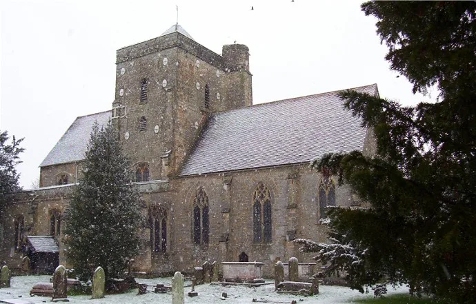
Marathon — CC BY-SA 2.0 via Wikimedia Commons licence

Plan your visit
- Typical visit
- 1.5 h–3 h
- Best time of year
- Year-round
- Nearest railway station
- Etchingham · 3.2 km
- Family-friendly
- Limited wheelchair access
About
Weald is a museum in england-south-east, United Kingdom, listed in the Wikipedia register of British heritage and tourism sites. See the linked Wikipedia article for full details.
Photo gallery
Protected designations
- Area of Outstanding Natural Beauty: High Weald
Designations sourced from Natural England open data under OGL v3.
Place summary
Weald is a museum located in South-East England. It focuses on the region's rural heritage and traditional crafts. The museum features various exhibits that showcase local history and culture.
AI-generated from the structured facts on this page (operator, designation, listing, era). Not a substitute for visiting.
Background
History
during the Roman occupation of Britain]] Prehistoric evidence suggests that, following the Mesolithic hunter-gatherers, the Neolithic inhabitants had turned to farming, with the resultant clearance of the forest. With the Iron Age came the first use of the Weald as an industrial area. Wealden sandstones contain ironstone, and with the additional presence of large amounts of timber for making charcoal for fuel, the area was the centre of the Wealden iron industry from then, through the Roman times, until the last forge was closed in 1813. The index to the Ordnance Survey Map of Roman Britain lists 33 iron mines, and 67% of these are in the Weald. The Weald is thought to have undergone…
Sourced from Wikipedia under CC BY-SA 4.0.
- Coordinates
- 51.0000, 0.4000
- County
- East Sussex
- District
- Rother
- Parish
- Burwash
- Postcode
- TN19 7BG
- Parliamentary constituency
- Bexhill and Battle
- Nearest railway station
- Etchingham — 3.2 km
Sources
- wikipedia: Weald (CC BY-SA 4.0)
Other places nearby

Burwash
Museums · 0.7 km

Burwash War Memorial
Memorials & monuments · 0.9 km

Kipling Statue
Public art & sculpture · 1.0 km

Mottynsden Manor
Manor houses · 1.9 km

Bateman's
Natural landmarks · 1.9 km

Fontridge Manor
Manor houses · 1.9 km
Cockham Manor
Manor houses · 2.1 km
Etchingham
Towns & cities · 2.1 km

Franchise Manor
Manor houses · 2.2 km

Socknersh Manor
Manor houses · 2.3 km

Etchingham
Villages · 2.4 km

Caird's Camping and Caravan Site
Campsites · 2.6 km
Nearby
📷 5Museums · South East England
Burwash
Burwash, archaically known as Burghersh, is a rural village and civil parish in the Rother district of East Sussex, England. Situated in the High Weald of Sussex some 15 miles (24 km) inland from the
📷 5Memorials & monuments · South East England
Burwash War Memorial
Burwash War Memorial — Grade II* listed building-listed memorial in england-south-east, United Kingdom.
📷 5Public art & sculpture · South East England
Kipling Statue
Kipling Statue — a public art in england-south-east, United Kingdom.
📷 5Manor houses · South East England
Mottynsden Manor
Mottynsden Manor — Grade II listed building-listed manor in england-south-east, United Kingdom.
📷 5Natural landmarks · South East England
Bateman's
Bateman's — a other in england-south-east, United Kingdom.
📷 5Manor houses · South East England
Fontridge Manor
Fontridge Manor — Grade II listed building-listed manor in england-south-east, United Kingdom.
Where to eat & stay near Weald
Places to stay
📷 5Campsites · South East England
Caird's Camping and Caravan Site
Caird's Camping and Caravan Site — a campsite in england south east.
 📷 5
📷 5Campsites · South East England
Glottenham Farm Glamping
Glottenham Farm Glamping — a campsite in england south east.
 📷 5
📷 5Campsites · South East England
Netherfield Place Farm
Netherfield Place Farm — a campsite in england south east.
 📷 5
📷 5Campsites · South East England
Park Farm Camping
Park Farm Camping — a campsite in england south east.
 📷 5
📷 5Campsites · South East England
Beech Estate Campsite
Beech Estate Campsite — a campsite in england south east.
 📷 5
📷 5Campsites · South East England
Cedar Gables Campsite
Cedar Gables Campsite — a campsite in england south east.
Places to eat & drink
 📷 7
📷 7Restaurants · South East England
The Royal George
The Royal George — a restaurant in england south east.
 📷 7
📷 7Historic pubs · South East England
The Old Bull Inn
The Old Bull Inn in England South East, United Kingdom.
 📷 5
📷 5Historic pubs · South East England
The Seven Stars Inn
The Seven Stars Inn is a 14th-century public house in Robertsbridge, East Sussex, a well-preserved example of a medieval building and a typical Sussex village pub. It is associated with historical eve
 📷 5
📷 5Historic pubs · South East England
The Cherry Tree Public House
The Cherry Tree Public House in England South East, United Kingdom.
 📷 5
📷 5Historic pubs · South East England
The Salehurst Halt Public House
The Salehurst Halt Public House in England South East, United Kingdom.
 📷 7
📷 7Historic pubs · South East England
John's Cross Public House
John's Cross Public House in England South East, United Kingdom.
More museums in this region
 📷 5
📷 5Museums · South East England
Coldrum Long Barrow
Coldrum Long Barrow — neolithic chambered long barrow near Trottiscliffe, Kent, England, UK.
 📷 5
📷 5Museums · South East England
Guildford House
Guildford House — house in Guildford, Surrey, England, UK.
 📷 5
📷 5Museums · South East England
Huguenot Museum
Huguenot Museum — museum in Rochester, England, UK.
 📷 5
📷 5Museums · South East England
Medway megaliths
Medway megaliths — group of long barrows in Kent, England.
Frequently asked questions
- Where is Weald?
- Weald is in East Sussex, South-East England, United Kingdom (postcode TN19 7BG), in the parish of Burwash.
- What is Weald?
- Weald — a museum in england-south-east, United Kingdom.
- How do I get to Weald?
- The nearest railway station is Etchingham, about 3.2 km away. Drivers can use postcode TN19 7BG.
- Is Weald a protected site?
- Yes — Weald is part of the High Weald National Landscape (AONB).
- How do I get to Weald?
- The nearest railway station is Etchingham, about 3.2 km away. Drivers can navigate to postcode TN19 7BG.