
Museums · South East England
Burwash
In or near Etchingham.
Burwash, archaically known as Burghersh, is a rural village and civil parish in the Rother district of East Sussex, England. Situated in the High Weald of Sussex some 15 miles (24 km) inland from the

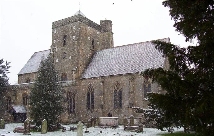
Colin Smith — CC BY-SA 2.0 via Wikimedia Commons licence

Plan your visit
- Typical visit
- 1.5 h–3 h
- Best time of year
- Year-round
- Nearest railway station
- Stonegate · 2.9 km
- Family-friendly
- Limited wheelchair access
Getting there & planning your visit
To visit Burwash, the nearest railway station is Stonegate, located 2.9 km away. The postcode for navigation is TN19 7BL. Please note that wheelchair accessibility is limited.
About
Burwash, archaically known as Burghersh, is a rural village and civil parish in the Rother district of East Sussex, England. Situated in the High Weald of Sussex some 15 miles (24 km) inland from the port of Hastings, it is located five miles (8.0 km) south-west of Hurst Green, on the A265 road, and on the River Dudwell, a tributary of the River Rother. In an area steeped in history, some nine miles (14 km) to the south-east lies Battle Abbey and eight miles (13 km) to the east is Bodiam Castle. Its main claim to fame is that for half of his life Rudyard Kipling (1865–1936) lived in the village at Bateman's. Kipling used the house's setting and the wider local area as the setting for many of his stories in Puck of Pook's Hill (1906) and the sequel Rewards and Fairies (1910), and there is a Kipling room at "The Bear" public house, one of two pubs located along Burwash High Street. Rudyard's son, John Kipling, died during the First World War and is named on the village war memorial at the end of Bell Alley Lane. He was named after Rudyard's father, the artist John Lockwood Kipling, (1837–1911), who provided illustrations for The Jungle Book. A complete collection of Kipling's works, including Just So Stories, Rewards and Fairies, The Man Who Would Be King and Kim, was published as the "Burwash Edition" (1941).
Photo gallery
Protected designations
- Area of Outstanding Natural Beauty: High Weald
Designations sourced from Natural England open data under OGL v3.
From the Wikipedia article
Burwash, archaically known as Burghersh, is a rural village and civil parish in the Rother district of East Sussex, England. Situated in the High Weald of Sussex some 15 miles (24 km) inland from the port of Hastings, it is located five miles (8.0 km) south-west of Hurst Green, on the A265 road, and on the River Dudwell, a tributary of the River Rother. In an area steeped in history, some nine miles (14 km) to the south-east lies Battle Abbey and eight miles (13 km) to the east is Bodiam Castle. Its main claim to fame is that for half of his life Rudyard Kipling (1865–1936) lived in the village at Bateman's. Kipling used the house's setting and the wider local area as the setting for many of his stories in Puck of Pook's Hill (1906) and the sequel Rewards and Fairies (1910), and there is a Kipling room at "The Bear" public house, one of two pubs located along Burwash High Street. Rudyard's son, John Kipling, died during the First World War and is named on the village war memorial at the end of Bell Alley Lane. He was named after Rudyard's father, the artist John Lockwood Kipling, (1837–1911), who provided illustrations for The Jungle Book. A complete collection of Kipling's works, including Just So Stories, Rewards and Fairies, The Man Who Would Be King and Kim, was published as the "Burwash Edition" (1941).
Excerpt from Wikipedia under CC BY-SA 4.0. See the source article linked in Sources below.
Background
History
coin of Edward III, dating from , found in Burwash]] The village developed as a trading place when King Henry III authorised a weekly market in 1252. He also allowed a three-day fair in May. Smuggling took place in the 18th and 19th centuries, and several smugglers' graves can still be seen in the churchyard of St Bartholomew's. The main road through Burwash, today's A265, was improved in the 18th and 19th centuries after it came under the administration of the Ringmer and Hurst Green turnpike trust. The trust was formed by the Hurst Green Road Act 1765 (5 Geo. 3. c. 64) after fifteen petitions were presented to Parliament on 25 December 1764 calling for the road to be turnpiked because it…
Sourced from Wikipedia under CC BY-SA 4.0.
- Coordinates
- 51.0000, 0.3900
- County
- East Sussex
- District
- Rother
- Parish
- Burwash
- Postcode
- TN19 7BL
- Parliamentary constituency
- Bexhill and Battle
- Nearest railway station
- Stonegate — 2.9 km
- Official site
- www.eastsussexinfigures.org.uk
Sources
- wikipedia: Burwash (CC BY-SA 4.0)
Other places nearby

Burwash War Memorial
Memorials & monuments · 0.3 km

Kipling Statue
Public art & sculpture · 0.4 km

Weald
Museums · 0.7 km

Mottynsden Manor
Manor houses · 1.2 km

Bateman's
Natural landmarks · 1.4 km

Franchise Manor
Manor houses · 1.6 km

Caird's Camping and Caravan Site
Campsites · 2.5 km

Fontridge Manor
Manor houses · 2.6 km
Cockham Manor
Manor houses · 2.8 km

Socknersh Manor
Manor houses · 2.8 km
Etchingham
Towns & cities · 2.8 km

Etchingham
Villages · 3.1 km
Nearby
📷 5Memorials & monuments · South East England
Burwash War Memorial
Burwash War Memorial — Grade II* listed building-listed memorial in england-south-east, United Kingdom.
📷 5Public art & sculpture · South East England
Kipling Statue
Kipling Statue — a public art in england-south-east, United Kingdom.
📷 5📷 5Manor houses · South East England
Mottynsden Manor
Mottynsden Manor — Grade II listed building-listed manor in england-south-east, United Kingdom.
📷 5Natural landmarks · South East England
Bateman's
Bateman's — a other in england-south-east, United Kingdom.
📷 5Manor houses · South East England
Franchise Manor
Franchise Manor — Grade II listed building-listed manor in england-south-east, United Kingdom.
Where to eat & stay near Burwash
Places to stay
📷 5Campsites · South East England
Caird's Camping and Caravan Site
Caird's Camping and Caravan Site — a campsite in england south east.
 📷 5
📷 5Campsites · South East England
Glottenham Farm Glamping
Glottenham Farm Glamping — a campsite in england south east.
 📷 5
📷 5Campsites · South East England
Netherfield Place Farm
Netherfield Place Farm — a campsite in england south east.
 📷 5
📷 5Campsites · South East England
Cedar Gables Campsite
Cedar Gables Campsite — a campsite in england south east.
 📷 5
📷 5Campsites · South East England
Beech Estate Campsite
Beech Estate Campsite — a campsite in england south east.
 📷 5
📷 5Campsites · South East England
Park Farm Camping
Park Farm Camping — a campsite in england south east.
Places to eat & drink
 📷 5
📷 5Historic pubs · South East England
The Cherry Tree Public House
The Cherry Tree Public House in England South East, United Kingdom.
 📷 7
📷 7Restaurants · South East England
The Royal George
The Royal George — a restaurant in england south east.
 📷 7
📷 7Historic pubs · South East England
The Old Bull Inn
The Old Bull Inn in England South East, United Kingdom.
 📷 5
📷 5Historic pubs · South East England
The Seven Stars Inn
The Seven Stars Inn is a 14th-century public house in Robertsbridge, East Sussex, a well-preserved example of a medieval building and a typical Sussex village pub. It is associated with historical eve
 📷 5
📷 5Historic pubs · South East England
The Salehurst Halt Public House
The Salehurst Halt Public House in England South East, United Kingdom.
 📷 7
📷 7Historic pubs · South East England
John's Cross Public House
John's Cross Public House in England South East, United Kingdom.
More museums in this region
 📷 5
📷 5Museums · South East England
Coldrum Long Barrow
Coldrum Long Barrow — neolithic chambered long barrow near Trottiscliffe, Kent, England, UK.
 📷 5
📷 5Museums · South East England
Guildford House
Guildford House — house in Guildford, Surrey, England, UK.
 📷 5
📷 5Museums · South East England
Huguenot Museum
Huguenot Museum — museum in Rochester, England, UK.
 📷 5
📷 5Museums · South East England
Medway megaliths
Medway megaliths — group of long barrows in Kent, England.
Frequently asked questions
- Where is Burwash?
- Burwash is in East Sussex, South-East England, United Kingdom (postcode TN19 7BL), in the parish of Burwash.
- What is Burwash?
- Burwash, archaically known as Burghersh, is a rural village and civil parish in the Rother district of East Sussex, England. Situated in the High Weald of Sussex some 15 miles (24 km) inland from the
- How do I get to Burwash?
- The nearest railway station is Stonegate, about 2.9 km away. Drivers can use postcode TN19 7BL.
- Is Burwash a protected site?
- Yes — Burwash is part of the High Weald National Landscape (AONB).
- How do I get to Burwash?
- The nearest railway station is Stonegate, about 2.9 km away. Drivers can navigate to postcode TN19 7BL.