
Historic houses · North East England
The Court House
In or near Mitford.
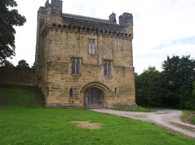
The Court House — house in Morpeth, Northumberland, England, UK.

Wikimedia Commons contributors — see linked file page for photographer and licence licence

Plan your visit
- Typical visit
- 1 h–2 h
- Nearest railway station
- Morpeth · 0.3 km
- Family-friendly
- Limited wheelchair access
Getting there & planning your visit
The Court House is located in Northumberland, with the nearest railway station being Morpeth, just 0.3 km away. Entry is free, but accessibility is limited for wheelchair users. The postcode for sat-nav is NE61 1YJ.
About
The Court House is a historic house in the United Kingdom — typically a country seat, manor, or town house with notable architecture or history. Heritage designation: Grade II* listed building. Wikidata describes it as: "house in Morpeth, Northumberland, England, UK". Coordinates: 55.1651°, -1.6854°.
Photo gallery
Official information
The Court House offers immersive live escape room experiences where teams solve puzzles and challenges within themed environments. Visitors can choose from various scenarios, including mystery and adventure themes, suitable for families, friends, and corporate events.
Protected designations
- Site of Special Scientific Interest: Northumberland Shore SSSI
Designations sourced from Natural England open data under OGL v3.
From the Wikipedia article
Morpeth Court is a former judicial structure on Castle Bank, Morpeth, Northumberland, England. The structure, which used to be the entrance block for a prison as well as the main courthouse for the area, is a Grade II* listed building.
Excerpt from Wikipedia under CC BY-SA 4.0. See the source article linked in Sources below.
Background
History
The original custodial facility for the area was Morpeth Castle which was used for incarcerating criminals from at least the early 16th century. When this arrangement became inadequate, the local lord of the manor, Charles Howard, 3rd Earl of Carlisle, made a site on Bridge Street available and a new prison opened there on 30 November 1704. The Bridge Street Prison was refurbished in 1774 but, by the early 19th century, it was also inadequate and it was converted into a private house. The proposed layout for the site on Castle Bank involved an octagonal outer wall, a rectangular prison building at the centre of the site and an entrance block at the front breaking the outer wall at that…
Sourced from Wikipedia under CC BY-SA 4.0.
- Coordinates
- 55.1651, -1.6854
- District
- Northumberland
- Parish
- Morpeth
- Postcode
- NE61 1YJ
- Parliamentary constituency
- North Northumberland
- Phone
- 01670 631439
- Established
- 1828
- Nearest railway station
- Morpeth — 0.3 km
Sources
- wikidata: Q17546908 (CC0)
- wikipedia: Morpeth Court (CC BY-SA 4.0)
- commons: Morpeth court building - geograph.org.uk - 1437848.jpg (CC BY-SA 4.0)
Other places nearby

Emily Wilding Davison statue
Public art & sculpture · 0.1 km
_63.jpg?width=1200)
Ha' Hill
Viewpoints · 0.2 km

Motte and bailey castle on Haw Hill
Literary houses · 0.2 km

Telford Bridge
Historic bridges · 0.2 km
Haw Hill
Castles · 0.2 km

Mafeking Park
Parks · 0.2 km
Morpeth Castle
Castles · 0.2 km
Morpeth Chantry
Historic churches · 0.2 km
Morpeth Chantry Bagpipe Museum
Museums · 0.2 km

Morpeth railway station
Memorials & monuments · 0.4 km

The Town Hall
Historic houses · 0.4 km

Morpeth
Archaeological sites · 0.4 km
Nearby
📷 3Public art & sculpture · North East England
Emily Wilding Davison statue
Emily Wilding Davison statue — a public art in North East England, United Kingdom.
📷 3📷 5Literary houses · North East England
Motte and bailey castle on Haw Hill
Motte and bailey castle on Haw Hill — a literary house museum in scotland lowlands.
📷 3Historic bridges · North East England
Telford Bridge
Telford Bridge — Grade II* listed building-listed bridge in scotland-lowlands, United Kingdom.
📷 5📷 4Where to eat & stay near The Court House
Places to stay
 📷 5
📷 5Campsites · North East England
Tranwell Farm Camp Site
Tranwell Farm Camp Site — a campsite in scotland lowlands.
 📷 5
📷 5Campsites · North East England
Selby Woods Scout Campsite
Selby Woods Scout Campsite — a campsite in scotland lowlands.
 📷 5
📷 5Caravan parks · North East England
Ellington Caravan Park
Ellington Caravan Park — a caravan park in scotland lowlands.
 📷 5
📷 5 📷 5
📷 5 📷 5
📷 5Caravan parks · North East England
Felmoor Park
Felmoor Park — a caravan park in scotland lowlands.
Places to eat & drink
 📷 5
📷 5 📷 5
📷 5Historic pubs · North East England
The Seven Stars Public House
The Seven Stars Public House in Scotland Lowlands, United Kingdom.
 📷 5
📷 5Historic pubs · North East England
The Anglers Arms
The Anglers Arms in Scotland Lowlands, United Kingdom.
 📷 5
📷 5Historic pubs · North East England
Northumberland Arms
Northumberland Arms in Scotland Lowlands, United Kingdom.
 📷 5
📷 5Historic pubs · North East England
Border Minstrel
Border Minstrel in Scotland Lowlands, United Kingdom.
 📷 3
📷 3Historic pubs · North East England
Red House Farm
Red House Farm in England North East, United Kingdom.
More historic houses in this region
 📷 3
📷 3Historic houses · North East England
Wayside cross known as Jenny Bradley 1000m north west of Bloworth Crossing on Greenhow Moor
Wayside cross known as Jenny Bradley 1000m north west of Bloworth Crossing on Greenhow Moor — a Grade II-listed historic house in england-yorkshire, United Kingdom.
 📷 3
📷 3Historic houses · North East England
Crackpot Hall
Crackpot Hall — a historic house in North East England, United Kingdom.
 📷 3
📷 3Historic houses · North East England
Bunton Mine shop
Bunton Mine shop — a historic house in North East England, United Kingdom.
 📷 3
📷 3Historic houses · North East England
Blakethwaite Mine
Blakethwaite Mine — a historic house in North East England, United Kingdom.
Frequently asked questions
- Where is The Court House?
- The Court House is in North-East England, United Kingdom (postcode NE61 1YJ), in the parish of Morpeth.
- What is The Court House?
- The Court House — house in Morpeth, Northumberland, England, UK.
- How do I get to The Court House?
- The nearest railway station is Morpeth, about 0.3 km away. The nearest town is Mitford. Drivers can use postcode NE61 1YJ.
- When was The Court House built?
- Built or established in 1828.
- Is The Court House a listed building?
- The Court House is officially recognised as Grade II* listed building listed.
- Is The Court House a protected site?
- Yes — The Court House is part of the Northumberland Shore SSSI Site of Special Scientific Interest.
- How do I get to The Court House?
- The nearest railway station is Morpeth, about 0.3 km away. Drivers can navigate to postcode NE61 1YJ.