National parks · East of England
The Broads
Also known as: Y Broads, Park Kenedhlek Lynnyn Norfolk
In or near Martham.
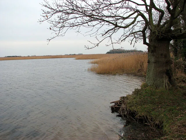
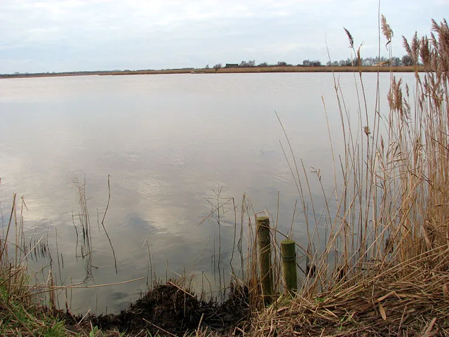
The Broads is a Network of rivers and lakes in East Anglia.

Photo by Peter Henry Emerson (Wikimedia Commons, Public domain) licence
Plan your visit
- Typical visit
- 4 h–8 h
- Best time of year
- Spring – autumn (Apr–Oct)
- Free entry
- Family-friendly
- Dog-friendly
Getting there & planning your visit
The Broads is located in Great Yarmouth, Norfolk, with the postcode NR29 4DJ. Entry is free. There is no nearest railway station mentioned, so please plan accordingly.
About
The Broads is a national park in the United Kingdom. It covers approximately 303 km². Designated in 1988. According to Wikipedia: "The Broads is a network of mostly navigable rivers and lakes in the English counties of Norfolk and Suffolk.". It is one of fifteen designated national parks across England, Scotland, and Wales, protected for its landscape and recreation value.
Photo gallery
Summary from the official site
The Broads is a national park known for its scenic waterways, diverse wildlife, and historical significance. It is managed by the Broads Authority, which aims to preserve its unique environment for both visitors and the local community.
Read more on the official property page.
Protected designations
- Site of Special Scientific Interest: Upper Thurne Broads and Marshes SSSI
- National Nature Reserve: MARTHAM BROAD
- Area of Outstanding Natural Beauty: Norfolk Coast
- Ramsar wetland: Broadland
Designations sourced from Natural England open data under OGL v3.
From the Wikipedia article
The Broads (known for marketing purposes as The Broads National Park) is a network of mostly navigable rivers and lakes in the English counties of Norfolk and Suffolk. Although the terms "Norfolk Broads" and "Suffolk Broads" are correctly used to identify specific areas within the two counties respectively, often the whole area is referred to as the Norfolk Broads. The lakes, known as broads, were formed by the flooding of peat workings. The Broads, and some surrounding land, were constituted as a special area with a level of protection similar to a national park by the Norfolk and Suffolk Broads Act 1988. The Broads Authority, a special statutory authority responsible for managing the area, became operational in 1989. The area is 303 square kilometres (117 sq mi), most of which is in Norfolk, with over 200 kilometres (120 mi) of navigable waterways. There are seven rivers and 63 broads, mostly less than 4 metres (13 ft) deep. Thirteen broads are generally open to navigation, with a further three having navigable channels. Some broads have navigation restrictions imposed on them in autumn and winter, although the legality of the restrictions is questionable. The Broads has similar status to the national parks in England and Wales; the Broads Authority has powers and duties akin to the National Parks but is also the third-largest inland navigation authority. Because of its navigation role the Broads Authority was established under its own legislation, Norfolk and Suffolk Broads Act 1988 which came into effect on 1 April 1989. The Broads Authority Act 2009, which was promoted through Parliament by the authority, is intended to improve public safety on the water.
Excerpt from Wikipedia under CC BY-SA 4.0. See the source article linked in Sources below.
Background
History
, one of the many historic drainage windpumps on the Norfolk Broads]] For many years the lakes known as broads were regarded as natural features of the landscape. It was only in the 1960s that Joyce Lambert proved that they were artificial features—flooded medieval peat excavations. In the Middle Ages the local monasteries began to excavate the peatlands as a turbary business, selling fuel to Norwich and Great Yarmouth. Norwich Cathedral took 320,000 tonnes of peat a year. Then the sea levels began to rise, and the pits began to flood. Despite the construction of windpumps and dykes, the flooding continued and resulted in the typical Broads landscape of today, with its reedbeds, grazing…
Sourced from Wikipedia under CC BY-SA 4.0.
- Coordinates
- 52.7242, 1.6408
- County
- Norfolk
- District
- Great Yarmouth
- Parish
- Somerton
- Postcode
- NR29 4DJ
- Parliamentary constituency
- Great Yarmouth
- Established
- 1988
- Official site
- www.broads-authority.gov.uk
Sources
- wikidata: Q1999046 (CC0)
- wikipedia: The Broads (CC BY-SA 4.0)
- commons: Ricking the reed.jpg (public-domain)
Featured in these 3 guides
Itinerary
All fifteen UK national parks, ranked
From the wild Cairngorms to the Norfolk Broads — every UK national park, opinionated.
Itinerary
The Norfolk Broads: Britain's biggest wetland
Seven rivers, 63 broads, and 125 miles of navigable waterway in the only national park you can sail.
Itinerary
Top 10 UK national parks ranked
All 15 UK national parks, ranked by what to expect.
Other places nearby
Martham Broad
Natural landmarks · 0.0 km

West Somerton Village Sign
Public art & sculpture · 0.9 km

West Somerton
Villages · 0.9 km

West Somerton War Memorial
Memorials & monuments · 1.5 km

Martham
Towns & cities · 1.8 km

Horsey Windpump
Natural landmarks · 1.9 km

Martham War Memorial, Churchyard of St Mary the Virgin
Memorials & monuments · 1.9 km

Burnley Hall
Historic houses · 2.0 km

Horsey Mere
Viewpoints · 2.0 km

Horsey
Villages · 2.0 km

Horsey Mere viewing area
Natural landmarks · 2.0 km
Horsey Mere
Natural landmarks · 2.2 km
Nearby
📷 5📷 3Public art & sculpture · East of England
West Somerton Village Sign
West Somerton Village Sign — a public art in england-east-midlands, United Kingdom.
📷 5📷 3Memorials & monuments · East of England
West Somerton War Memorial
West Somerton War Memorial — Grade II listed building-listed memorial in england-east-midlands, United Kingdom.
Flagship📷 5Towns & cities · East of England
Martham
Martham — village in Great Yarmouth, Norfolk, England, UK.
📷 3Natural landmarks · East of England
Horsey Windpump
Horsey Windpump — a other in england-east-midlands, United Kingdom.
Where to eat & stay near The Broads
Places to stay
 📷 5
📷 5 📷 5
📷 5Campsites · East of England
Waxham Sands Holiday Park
Waxham Sands Holiday Park — a campsite in england east midlands.
 📷 5
📷 5 📷 5
📷 5Caravan parks · East of England
Winterton Holidays
Winterton Holidays — a caravan park in england east midlands.
 📷 5
📷 5 📷 5
📷 5Places to eat & drink
 📷 5
📷 5 📷 5
📷 5 📷 5
📷 5Historic pubs · East of England
Two Necked Swan Public House
Two Necked Swan Public House in England East, United Kingdom.
 📷 5
📷 5Historic pubs · East of England
St Johns Head Public House
St Johns Head Public House in England East, United Kingdom.
 📷 5
📷 5Historic pubs · East of England
Dukes Head Public House
Dukes Head Public House in England East, United Kingdom.
 📷 5
📷 5More national parks in this region
 📷 4
📷 4National parks · East of England
Beccles bell tower
Beccles bell tower is a free-standing Grade I listed edifice associated with the adjacent St. Michael's Church in the market town of Beccles, Suffolk, England. It stands near the edge of a cliff overl
Frequently asked questions
- Where is The Broads?
- The Broads is in Norfolk, the East Midlands, United Kingdom (postcode NR29 4DJ), in the parish of Somerton.
- What is The Broads?
- The Broads is a Network of rivers and lakes in East Anglia.
- How do I get to The Broads?
- Drivers can use postcode NR29 4DJ.
- When was The Broads built?
- Built or established in 1988.
- Who owns The Broads?
- The Broads is owned by Broads Authority.
- Is The Broads a protected site?
- Yes — The Broads is part of the Upper Thurne Broads and Marshes SSSI Site of Special Scientific Interest and the MARTHAM BROAD National Nature Reserve.
- Is The Broads free to visit?
- Yes, The Broads is free to enter.
- How do I get to The Broads?
- Drivers can navigate to postcode NR29 4DJ. It sits within the Great Yarmouth parliamentary constituency.