
Manor houses · South West England
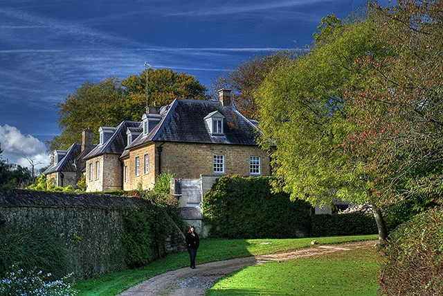
Strode Manor
In or near Netherbury.
Strode Manor — Grade II listed building-listed manor in england-south-west, United Kingdom.

Les Mildon — CC BY-SA 2.0 via Wikimedia Commons licence

Plan your visit
- Typical visit
- 1 h–2 h
- Nearest railway station
- Crewkerne · 9.8 km
- Limited wheelchair access
Getting there & planning your visit
To visit Strode Manor, the nearest railway station is Crewkerne, which is 9.8 km away. The postcode for sat-nav is DT6 5NG. Please note that wheelchair accessibility is limited.
About
Strode Manor is a Grade II listed building-listed manor in england-south-west, United Kingdom, registered on the National Heritage List for England (NHLE entry 1216092). Listed status protects buildings and structures of special architectural or historic interest. See the linked Wikipedia article for further details.
Photo gallery
Heritage listing
Details SY 49 NW 6/161 4-12-1951 NETHERBURY SOUTH BOWOOD Strode Manor II Large Regency Villa. c.1830. Stone walls, rendered with moulded stone plat-band. Slate roofs, hipped with large projecting eaves, planked in. Rendered stacks at front and side eaves. House of 2 overlapping cubes at right angles to each other. 2 storeys. 3 windows to front elevation, sashes with thin glazing-bars and moulded window frames. South elevation (terrace) has 5 sashes. Blind, yet glazed, sash windows to front elevation right hand, to preserve external symmetry. Front doorway left of centre, moulded architraves and elliptical head, flush-panelled reveals and head. 2-leaf doors, flush-panelled with four lights. Elliptical fanlight over with-glazing-bars. Porch: coupled Doric stone columns with a plain stone entablature over. Between the columns, and at the sides of porch is glazed-in. Listing NGR: SY4479599053 Legacy The contents of this record have been generated from a legacy data system. Legacy System number: 401414 Legacy System: LBS
From the Historic England List Entry under OGL v3.
Protected designations
- Area of Outstanding Natural Beauty: Dorset
Designations sourced from Natural England open data under OGL v3.
Place summary
Strode Manor is a Grade II listed building located in South-West England. This historic manor is noted for its architectural significance and preservation status within the region.
AI-generated from the structured facts on this page (operator, designation, listing, era). Not a substitute for visiting.
- Coordinates
- 50.7853, -2.7771
- District
- Dorset
- Parish
- Netherbury
- Postcode
- DT6 5NG
- Parliamentary constituency
- West Dorset
- Nearest railway station
- Crewkerne — 9.8 km
- Official site
- heritage.dorsetcouncil.gov.uk
Sources
- wikidata: Q26510907 (CC0)
Other places nearby

Furleigh Estate Wine Tours
Natural landmarks · 0.5 km

Netherbury War Memorial
Memorials & monuments · 1.8 km

Congregational Chapel
Chapels · 1.8 km
Slape Manor
Stately homes · 1.9 km

Netherbury
Towns & cities · 2.0 km

Mill House
Watermills · 2.0 km

Stoke Abbott
Villages · 2.0 km

Bide Yer
Caravan parks · 2.3 km

Stokewater Meadow Donkey Walking Days
Natural landmarks · 2.3 km

Gerrard's Hill
Viewpoints · 2.6 km

Parnham House
Historic houses · 2.7 km

Pilsdon View Camping
Campsites · 2.7 km
Nearby
📷 3Natural landmarks · South West England
Furleigh Estate Wine Tours
Furleigh Estate Wine Tours — a other in england-south-west, United Kingdom.
📷 3Memorials & monuments · South West England
Netherbury War Memorial
Netherbury War Memorial — Grade II listed building-listed memorial in england-south-west, United Kingdom.
📷 5Chapels · South West England
Congregational Chapel
Congregational Chapel — chapel in Stoke Abbott, West Dorset, England, UK.
Flagship📷 3Stately homes · South West England
Slape Manor
Slape Manor — manor house in Netherbury, Dorset, England, UK.
📷 5Towns & cities · South West England
Netherbury
Netherbury — village and civil parish in Dorset, England, UK.
📷 5Where to eat & stay near Strode Manor
Places to stay
📷 5Caravan parks · South West England
Bide Yer
Bide Yer — a caravan park in england south west.
📷 5Campsites · South West England
Pilsdon View Camping
Pilsdon View Camping — a campsite in england south west.
 📷 5
📷 5Campsites · South West England
Greenacres Campsite.
Greenacres Campsite. — a campsite in england south west.
📷 5Caravan parks · South West England
Washingpool Caravan Site
Washingpool Caravan Site — a caravan park in england south west.
 📷 5
📷 5Campsites · South West England
The Dorset Hideaway
The Dorset Hideaway — a campsite in england south west.
 📷 5
📷 5Hotels · South West England
The Bull Hotel
The Bull Hotel — a hotel in england south west.
Places to eat & drink
 📷 5
📷 5Historic pubs · South West England
Eight Bells Inn
Eight Bells Inn in England South West, United Kingdom.
 📷 7
📷 7Restaurants · South West England
Brassica
Brassica — a restaurant in england south west.
 📷 5
📷 5 📷 7
📷 7 📷 5
📷 5Historic pubs · South West England
10 North Street
10 North Street in England South West, United Kingdom.
 📷 5
📷 5More places in this region
 📷 5
📷 5Manor houses · South West England
Westwood Manor, National Trust
Westwood Manor, National Trust — a manor in england-south-east, United Kingdom.
 📷 5
📷 5Manor houses · South West England
Great Chalfield Manor
Great Chalfield Manor — a manor in england-south-east, United Kingdom.
 📷 5
📷 5Manor houses · South West England
Wolfeton House
Wolfeton House — a manor in england-south-east, United Kingdom.
 📷 5
📷 5Frequently asked questions
- Where is Strode Manor?
- Strode Manor is in South-West England, United Kingdom (postcode DT6 5NG), in the parish of Netherbury.
- What is Strode Manor?
- Strode Manor — Grade II listed building-listed manor in england-south-west, United Kingdom.
- How do I get to Strode Manor?
- The nearest railway station is Crewkerne, about 9.8 km away. Drivers can use postcode DT6 5NG.
- Is Strode Manor a listed building?
- Strode Manor is officially recognised as Grade II listed building listed.
- Is Strode Manor a protected site?
- Yes — Strode Manor is part of the Dorset National Landscape (AONB).
- How do I get to Strode Manor?
- Drivers can navigate to postcode DT6 5NG. It sits within the West Dorset parliamentary constituency.