Towns & cities · South West England
Netherbury
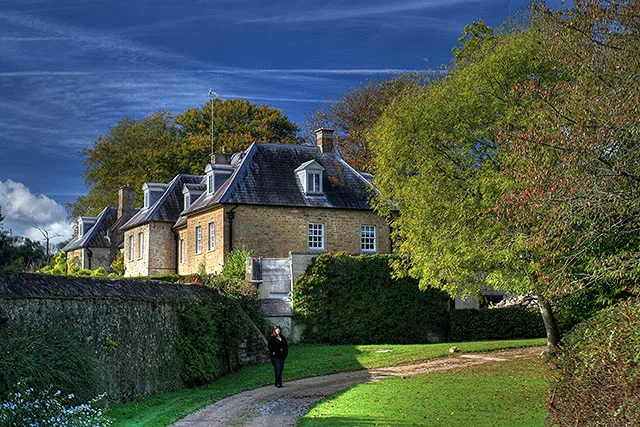
Netherbury — village and civil parish in Dorset, England, UK.

Wikimedia Commons contributors — see linked file page for photographer and licence licence
Plan your visit
- Typical visit
- 3 h–6 h
- Nearest railway station
- Crewkerne · 9.4 km
- Free entry
- Family-friendly
- Dog-friendly
About
Netherbury is a town, city, village or settlement in the United Kingdom. Recent population estimates put it at around 980 people. Wikidata describes it as: "village and civil parish in Dorset, England, UK". Coordinates: 50.7910°, -2.7500°.
Photo gallery
Protected designations
- Area of Outstanding Natural Beauty: Dorset
Designations sourced from Natural England open data under OGL v3.
From the Wikipedia article
Netherbury is a village and civil parish in the English county of Dorset. It lies within the Dorset Council administrative area, by the small River Brit, 1.5 miles (2.4 km) south of Beaminster and 4 miles (6.4 km) north of Bridport. The A3066 road connecting those towns lies 0.5 miles to the east.
Excerpt from Wikipedia under CC BY-SA 4.0. See the source article linked in Sources below.
- Coordinates
- 50.7910, -2.7500
- District
- Dorset
- Parish
- Netherbury
- Postcode
- DT6 5LX
- Parliamentary constituency
- West Dorset
- Population
- 980
- Nearest railway station
- Crewkerne — 9.4 km
- Official site
- www.neighbourhood.statistics.gov.uk
Sources
- wikidata: Q748497 (CC0)
- wikipedia: Netherbury (CC BY-SA 4.0)
- commons: Netherbury, parish church of St. Mary - geograph.org.uk - 519517.jpg (CC BY-SA 4.0)
Other places nearby
Loading nearby places…
Nearby
 📷 5
📷 5Watermills · South West England
Mill House
Mill House is a watermill in the United Kingdom.
 📷 3
📷 3Memorials & monuments · South West England
Netherbury War Memorial
Netherbury War Memorial — Grade II listed building-listed memorial in england-south-west, United Kingdom.
 Flagship📷 3
Stately homes · South West England
Slape Manor
Slape Manor — manor house in Netherbury, Dorset, England, UK.
 📷 5
📷 5Historic houses · South West England
Parnham House
Parnham House — Grade I listed house in West Dorset, England, UK.
 📷 3
📷 3Natural landmarks · South West England
Stokewater Meadow Donkey Walking Days
Stokewater Meadow Donkey Walking Days — a other in england-south-west, United Kingdom.
 📷 5
📷 5Towns & cities · South West England
Melplash
Melplash — village in Dorset, United Kingdom.
Where to eat & stay near Netherbury
Places to stay
 📷 5
📷 5Caravan parks · South West England
Bide Yer
Bide Yer — a caravan park in england south west.
 📷 5
📷 5Campsites · South West England
Pilsdon View Camping
Pilsdon View Camping — a campsite in england south west.
 📷 5
📷 5Campsites · South West England
Greenacres Campsite.
Greenacres Campsite. — a campsite in england south west.
📷 5Caravan parks · South West England
Washingpool Caravan Site
Washingpool Caravan Site — a caravan park in england south west.
 📷 5
📷 5Hotels · South West England
Hooke Court
Hooke Court — a hotel in england south west.
 📷 5
📷 5Hotels · South West England
The Bull Hotel
The Bull Hotel — a hotel in england south west.
Places to eat & drink
 📷 5
📷 5Historic pubs · South West England
Eight Bells Inn
Eight Bells Inn in England South West, United Kingdom.
 📷 5
📷 5Restaurants · South West England
Brassica
Brassica — a restaurant in england south west.
 📷 5
📷 5Historic pubs · South West England
Pymore Inn
Pymore Inn in England South West, United Kingdom.
 📷 5
📷 5Historic pubs · South West England
Loders Arms Inn
Loders Arms Inn in England South West, United Kingdom.
 📷 5
📷 5Historic pubs · South West England
The Boot Inn
The Boot Inn in England South West, United Kingdom.
 📷 5
📷 5Historic pubs · South West England
10 North Street
10 North Street in England South West, United Kingdom.
More towns in this region
 Flagship📷 10
Towns & cities · South West England
All Saints
All Saints — village and civil parish in Devon, England, UK.
 Flagship📷 10
Towns & cities · South West England
Axmouth
Axmouth — village and civil parish in Devon, England, UK.
 ★ Iconic📷 10
Towns & cities · South West England
Beer
Beer — village and civil parish in Devon, UK.
 Flagship📷 10
Towns & cities · South West England
Branscombe
Branscombe — village and civil parish in Devon, UK.
Frequently asked questions
- Where is Netherbury?
- Netherbury is in South-West England, United Kingdom (postcode DT6 5LX), in the parish of Netherbury.
- What is Netherbury?
- Netherbury — village and civil parish in Dorset, England, UK.
- How do I get to Netherbury?
- The nearest railway station is Crewkerne, about 9.4 km away. Drivers can use postcode DT6 5LX.
- Is Netherbury a protected site?
- Yes — Netherbury is part of the Dorset National Landscape (AONB).
- Is Netherbury free to visit?
- Yes, Netherbury is free to enter.
- How do I get to Netherbury?
- Drivers can navigate to postcode DT6 5LX. It sits within the West Dorset parliamentary constituency.