
Natural landmarks · North West England
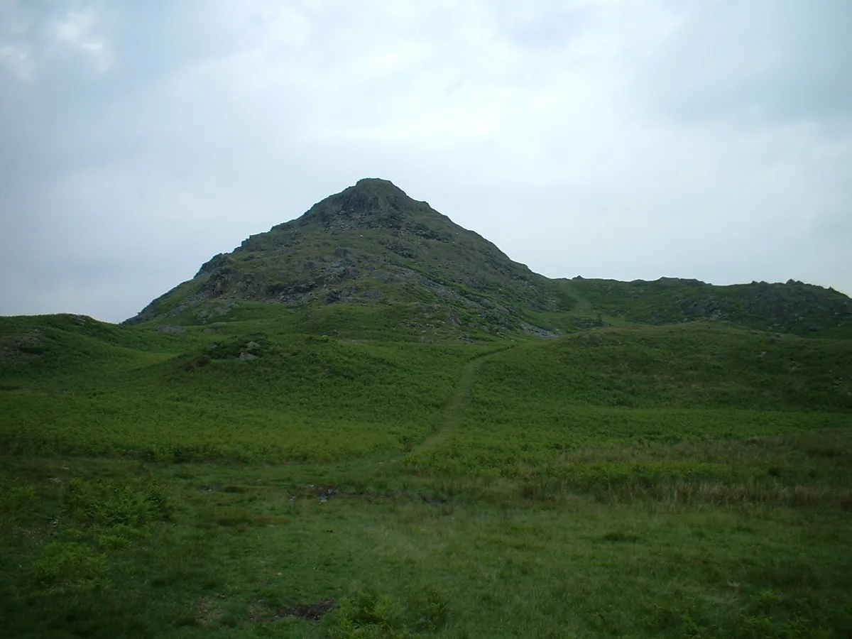
Stickle Pike
In or near Seathwaite.
Stickle Pike — mountain in the United Kingdom.

Wikimedia Commons contributors — see linked file page for photographer and licence licence

Plan your visit
- Typical visit
- 1 h–2 h
- Nearest railway station
- Foxfield · 6.5 km
- Free entry
- Dog-friendly
Getting there & planning your visit
To visit Stickle Pike, the nearest railway station is Foxfield, located 6.5 km away. The postcode for navigation is LA20 6BA, and entry is free.
About
Stickle Pike is a named natural landmark in the United Kingdom. Wikidata describes it as: "mountain in the United Kingdom". Coordinates: 54.3167°, -3.2167°.
Photo gallery
Protected designations
- Site of Special Scientific Interest: Duddon Valley Woodlands SSSI
Designations sourced from Natural England open data under OGL v3.
From the Wikipedia article
Stickle Pike is an outlying fell located in the southern Lake District near the small town of Broughton-in-Furness, with the summit situated between the lower Duddon Valley and the quiet smaller valley of Dunnerdale. Despite its low altitude (375 m, or 1230 ft) the sharp, conical summit is prominent in views from the Broughton and high Furness areas. As with many of the Dunnerdale and Coniston fells, there are reminders of the area's former mining past in the form of many spoil heaps, disused levels and shafts. The fell is also notable for its wide-ranging views despite its low altitude, especially to the Scafells to the north and the sands of the Duddon Estuary to the south. A "stickle" is a hill with a prominent rocky top. The fell is most easily (and commonly) ascended from the Kiln Bank fell road between Hall Dunnerdale and Broughton Mills, with the top lying less than half a mile from the road summit. An alternative ascent (suggested by Alfred Wainwright) can be made from Broughton Mills along the Great Stickle/Tarn Hill ridge, with a return either down the Dunnerdale valley road or via the bridleway on the east side of the valley. The fell is the subject of a chapter of Wainwright's book The Outlying Fells of Lakeland. His clockwise circuit from Broughton Mills includes Great Stickle at 1,001 feet (305 m), Tarn Hill at 1,231 feet (375 m), Stickle Pike, a "nameless summit" at 1,183 feet (361 m), north of Raven's Crag which is bypassed, and The Knott at 925 feet (282 m). This last shares its name with The Knott above Hayeswater in the far eastern fells and another outlying fell near Stainton Pike, as well as with Knott north of Skiddaw.
Excerpt from Wikipedia under CC BY-SA 4.0. See the source article linked in Sources below.
- Coordinates
- 54.3167, -3.2167
- District
- Westmorland and Furness
- Parish
- Dunnerdale-with-Seathwaite
- Postcode
- LA20 6BA
- Parliamentary constituency
- Barrow and Furness
- Nearest railway station
- Foxfield — 6.5 km
Sources
- wikidata: Q7616267 (CC0)
- wikipedia: Stickle Pike (CC BY-SA 4.0)
- commons: Sticklepike.jpg (CC BY-SA 4.0)
Other places nearby

Tarn Hill
Mountains & hills · 0.2 km

Great Stickle
Natural landmarks · 0.4 km

Hovel Knott
Mountains & hills · 0.7 km

Cinder Hill
Mountains & hills · 0.8 km

Hollowscar Hill End
Mountains & hills · 0.8 km
Stickle Pike
Mountains & hills · 0.9 km

The Knott
Mountains & hills · 1.5 km

Potherilt Hill
Mountains & hills · 1.6 km

Ulpha Bridge (That Part In Dunnerdale With Seathwaite Cp)
Historic bridges · 1.7 km

Raven's Crag
Mountains & hills · 1.7 km

Blacksmiths Arms
Historic houses · 1.9 km

Blacksmiths Arms
Historic pubs · 1.9 km
Nearby
📷 5Mountains & hills · North West England
Tarn Hill
Tarn Hill — mountain in england north west. Elevation: 313 m.
📷 3📷 5Mountains & hills · North West England
Hovel Knott
Hovel Knott — mountain in england north west. Elevation: 224 m.
📷 5Mountains & hills · North West England
Cinder Hill
Cinder Hill — mountain in england north west. Elevation: 160 m.
📷 5Mountains & hills · North West England
Hollowscar Hill End
Hollowscar Hill End — mountain in england north west. Elevation: 312 m.
📷 3Where to eat & stay near Stickle Pike
Places to stay
 📷 7
📷 7Hotels · North West England
The Black Cock Inn
The Black Cock Inn — a hotel in england north west.
 📷 5
📷 5Campsites · North West England
Turner Hall Farm Campsite
Turner Hall Farm Campsite — a campsite in england north west.
 📷 5📷 5
Campsites · North West England
Birch Bank Campsite
Birch Bank Campsite — a campsite in england north west.
 📷 4
📷 4Campsites · North West England
Baystone Bank Farm Camping Site
Baystone Bank Farm Camping Site — a campsite in england north west.
 📷 5
📷 5Caravan parks · North West England
Shepherd's View Caravan Site
Shepherd's View Caravan Site — a caravan park in england north west.
Places to eat & drink
📷 5Historic pubs · North West England
Blacksmiths Arms
Blacksmiths Arms in England North West, United Kingdom.
 📷 7
📷 7Historic pubs · North West England
Church House Public House
Church House Public House in England North West, United Kingdom.
 📷 5
📷 5Restaurants · North West England
The Terrace Coffee House and Restaurant
The Terrace Coffee House and Restaurant — a restaurant in england north west. Cuisine: sandwich;lunch.
 📷 5
📷 5Historic pubs · North West England
Hoppers Public House
Hoppers Public House in England North West, United Kingdom.
 📷 5
📷 5Historic pubs · North West England
Sun Cottage Sun Inn Public House
Sun Cottage Sun Inn Public House in England North West, United Kingdom.
 📷 5
📷 5Historic pubs · North West England
Chappells Tavern
Chappells Tavern in England North West, United Kingdom.
More natural landmarks in this region
 📷 3
📷 3Natural landmarks · North West England
Statue of Oliver Cromwell
Statue of Oliver Cromwell — Public artwork (statue).
 📷 3
📷 3Natural landmarks · North West England
Dagfields Craft Centre
Dagfields Craft Centre — a place in North West England, United Kingdom.
 📷 3
📷 3Natural landmarks · North West England
Weaver Valley Cruises
Weaver Valley Cruises — a place in North West England, United Kingdom.
 📷 3
📷 3Natural landmarks · North West England
Golden Gates
Golden Gates — a place in North West England, United Kingdom.
Frequently asked questions
- Where is Stickle Pike?
- Stickle Pike is in North-West England, United Kingdom (postcode LA20 6BA), in the parish of Dunnerdale-with-Seathwaite.
- What is Stickle Pike?
- Stickle Pike — mountain in the United Kingdom.
- How do I get to Stickle Pike?
- The nearest railway station is Foxfield, about 6.5 km away. The nearest town is Seathwaite. Drivers can use postcode LA20 6BA.
- Is Stickle Pike a protected site?
- Yes — Stickle Pike is part of the Duddon Valley Woodlands SSSI Site of Special Scientific Interest.
- Is Stickle Pike free to visit?
- Yes, Stickle Pike is free to enter.
- How do I get to Stickle Pike?
- The nearest railway station is Foxfield, about 6.5 km away. Drivers can navigate to postcode LA20 6BA.