
Other places · Central Scotland
Stenhousemuir
Also known as: Monadh Thaigh Chloiche
In or near Camelon.
Stenhousemuir in Scotland Islands, United Kingdom.

Richard Webb — CC BY-SA 2.0 via Wikimedia Commons licence

Plan your visit
- Typical visit
- 1 h–2 h
- Nearest railway station
- Larbert · 1.6 km
Getting there & planning your visit
To visit Stenhousemuir in the Scottish Highlands, the nearest railway station is Larbert, located 1.6 km away. The postcode for Stenhousemuir is FK5 4DB. Entry details are not specified.
About
Stenhousemuir is a place of interest in Scotland Islands, United Kingdom — drawn from open-data sources for visitor reference. See the linked Wikipedia article for the full description.
Photo gallery
From the Wikipedia article
Stenhousemuir (; Scottish Gaelic: Featha Thaigh nan Clach) is a town in the Central Lowlands of Scotland. It lies within the Falkirk council area of Scotland. The town is two miles (three kilometres) north-northwest of Falkirk and directly adjoins to Larbert in the west, where the nearest rail access is located. The villages of Carron and Carronshore adjoin Stenhousemuir to the east but to a lesser extent. Historically, Stenhousemuir lies with the historic county of Stirlingshire. At the 2001 census it showed that it had a resident population of 10,351 but according to a 2009 estimate this was revised to around 10,190 residents. The combined population of the four localities in 2011 was 24,722, representing about 15% of the Falkirk council area total. In 2008, a £15 million town centre development scheme was completed and opened which provided a new civic square, a library and large retailing outlets for Stenhousemuir.
Excerpt from Wikipedia under CC BY-SA 4.0. See the source article linked in Sources below.
Background
History
book.]] The "stone house" from which the village took its name was a Roman building on the north of the Carron River Valley known in later centuries as Arthur's O'on, i.e. King Arthur's oven. It is no longer to be seen, having been demolished to rebuild a dam on the River Carron by Sir Michael Bruce of Stenhouse in 1743. The stones were swept away in a flood soon after. Detailed drawings had been made in the 1720s and a replica was made in 1763 to serve as a dovecote on the roof of the stable block of Penicuik House in Midlothian, and this remains. The site of the original building has been localised to the garden of a modern house on a housing estate, apparently by the American academic…
Sourced from Wikipedia under CC BY-SA 4.0.
- Coordinates
- 56.0280, -3.8060
- District
- Falkirk
- Postcode
- FK5 4DB
- Parliamentary constituency
- Alloa and Grangemouth
- Nearest railway station
- Larbert — 1.6 km
- Official site
- www.falkirk.gov.uk
Sources
- wikidata: Q3358826 (CC0)
- wikipedia: Stenhousemuir (CC BY-SA 4.0)
Other places nearby
Stenhouse and Carron Parish Church
Historic churches · 0.1 km

Ochilview Park
Stadiums · 0.5 km

Tryst Church and Hall, Kirk Avenue, Stenhousemuir
Historic churches · 0.5 km
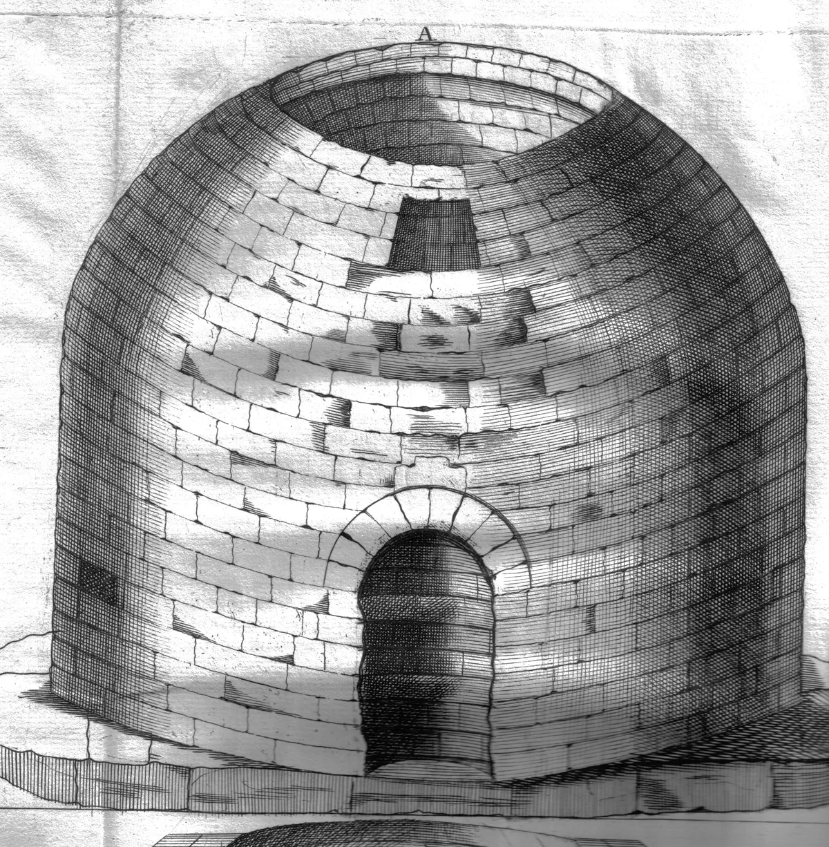
Arthur's O'on temple
Hill forts · 0.6 km
Arthur's O'On
Historic houses · 0.6 km

Carron Company
Other places · 0.7 km

A88 road
Natural landmarks · 1.0 km

Carron
Other places · 1.1 km

Heritage Trail
Public art & sculpture · 1.2 km
Stirling District Lunatic Asylum
Other places · 1.2 km
Carronvale House
Historic houses · 1.4 km

Decorated phone box
Public art & sculpture · 1.5 km
Nearby
📷 5Historic churches · Central Scotland
Stenhouse and Carron Parish Church
Stenhouse and Carron Parish Church — category A listed building-listed church in scotland-central, United Kingdom.
📷 3Stadiums · Central Scotland
Ochilview Park
Ochilview Park — stadium in Falkirk, Scotland, UK.
📷 5Historic churches · Central Scotland
Tryst Church and Hall, Kirk Avenue, Stenhousemuir
Tryst Church and Hall, Kirk Avenue, Stenhousemuir — category B listed building-listed church in scotland-central, United Kingdom.
📷 3Hill forts · Central Scotland
Arthur's O'on temple
Arthur's O'on temple — probable Roman temple near Falkirk, Scotland, destroyed in 1743.
📷 3Historic houses · Central Scotland
Arthur's O'On
Arthur's O'On — a historic house in Central Scotland, United Kingdom.
📷 4Where to eat & stay near Stenhousemuir
Places to stay
 📷 5
📷 5Hotels · Central Scotland
Glenbervie House Hotel
Glenbervie House Hotel — a hotel in scotland central.
 📷 6
📷 6 📷 7
📷 7 📷 5
📷 5Hotels · Central Scotland
The Grange Manor
The Grange Manor — a hotel in scotland central.
 📷 5
📷 5Campsites · Central Scotland
Wheel Caravan park
Wheel Caravan park — a campsite in scotland central.
 📷 5
📷 5Hotels · Central Scotland
Dunmar House Hotel
Dunmar House Hotel — a hotel in scotland central.
Places to eat & drink
 📷 7
📷 7Historic pubs · Central Scotland
Ye Olde House Inn, 25-26 Forth Street, Kincardine On Forth
Ye Olde House Inn, 25-26 Forth Street, Kincardine On Forth in Scotland Central, United Kingdom.
 📷 5
📷 5Historic pubs · Central Scotland
Dennyloanhead
Dennyloanhead in Scotland Islands, United Kingdom.
 📷 6
📷 6Historic pubs · Central Scotland
The Gothenburg
The Gothenburg in Scotland Islands, United Kingdom.
 📷 7
📷 7Historic pubs · Central Scotland
Red Lion Inn, Low Causeway, Culross
Red Lion Inn, Low Causeway, Culross in Scotland Central, United Kingdom.
 📷 7
📷 7 📷 5
📷 5Historic pubs · Central Scotland
The Masonic Arms, 62 Main Street, Cumbernauld Village
The Masonic Arms, 62 Main Street, Cumbernauld Village in Scotland Central, United Kingdom.
More places in this region
 📷 3
📷 3 📷 3
📷 3 📷 5
📷 5 📷 5
📷 5Frequently asked questions
- Where is Stenhousemuir?
- Stenhousemuir is in central Scotland, United Kingdom (postcode FK5 4DB).
- What is Stenhousemuir?
- Stenhousemuir in Scotland Islands, United Kingdom.
- How do I get to Stenhousemuir?
- The nearest railway station is Larbert, about 1.6 km away. The nearest town is Camelon. Drivers can use postcode FK5 4DB.
- How do I get to Stenhousemuir?
- The nearest railway station is Larbert, about 1.6 km away. Drivers can navigate to postcode FK5 4DB.