
Mountains & hills · Scottish Islands
Sotan
Also known as: Beárnaraigh
Sotan — Named summit at 193 m.

Wikimedia Commons contributors — see linked file page for photographer and licence licence

Plan your visit
- Typical visit
- 3 h–8 h
- Best time of year
- Late spring – early autumn (May–Oct)
- Free entry
- Dog-friendly
About
Sotan is a named summit in the United Kingdom. Wikidata describes it as: "Named summit at 193 m.". Coordinates: 56.7831°, -7.6450°.
Photo gallery
From the Wikipedia article
Barra Head, also known as Berneray (Scottish Gaelic: Beàrnaraigh), is the southernmost island of the Outer Hebrides in Scotland. Within the Outer Hebrides, it forms part of the Barra Isles archipelago. Originally, Barra Head only referred to the southernmost headland of Berneray but is now a common name for the entire island. The highest point of the island is Sotan, a Marilyn. There are numerous prehistoric structures on the island and permanent occupation by 20–50 individuals occurred throughout the historic period, peaking in the 19th century. The economy of the residents was based on agriculture, fishing and fowling. The cliffs provide nesting sites for seabirds in such profusion that Berneray has been designated as a Special Protection Area. The Barra Head Lighthouse, designed by Robert Stevenson, has operated since 1833. From 1931 to 1980 Barra Head was inhabited only by the lighthouse keepers and their wives but the lighthouse is now automated and the island completely uninhabited. The rough seas that surround the island have been used to test prototype lifeboats.
Excerpt from Wikipedia under CC BY-SA 4.0. See the source article linked in Sources below.
Background
History
Berneray was inhabited from prehistoric times until the 20th century; Historic Scotland have identified eighty-three archaeological sites on the island, the majority being of a pre-medieval date. There are four chambered tombs, five cists and five other sites assumed to be burial cairns, suggesting a significant settlement in the Neolithic and Bronze Age. The fort of Dùn Briste (the broken fort) lies to the north west and a second site nearby dating to the Iron Age was largely destroyed during the construction of the lighthouse. A century later Edward MacQueen wrote that he believed it had served "as a pharos or watch tower". There is also the presumed site of a chapel near MacLean's Point…
Description
<div style="float:left; margin-right: 1em;"> {| class="wikitable" ! Year ! Population (a) ! Population (b) |- | 1764 | 20 | |- | 1794 | 3 families | |- | 1841 | 21 | 30 |- | 1851 | 28 | 44 |- | 1861 | 20 | 33 |}</div><div style="float:left;"> {| class="wikitable" ! Year ! Population (a) ! Population (b) |- | 1871 | 20 | 38 |- | 1881 | 21 | 56 |- | 1891 | 17 | 36 |- | 1901 | – | 17 |- | 1911 | 0 | 5 |}</div> Notes:
Sourced from Wikipedia under CC BY-SA 4.0.
- Coordinates
- 56.7831, -7.6450
- Official site
- www.ordnancesurvey.co.uk
Sources
- osm: n3396532625 (ODbL)
- wikipedia: Barra Head (CC BY-SA 4.0)
- commons: Barrahead.jpg (CC BY-SA 4.0)
Other places nearby
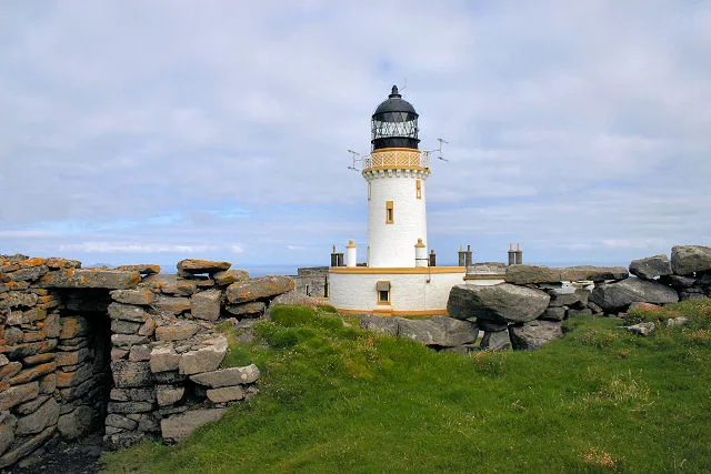
Barra Head Lighthouse
Lighthouses · 0.6 km
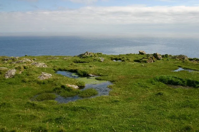
Barra Head
Islands · 0.6 km

Sròn an Dùin
Mountains & hills · 0.6 km
Berneray
Vineyards · 0.6 km
Berneray, Dun Briste
Vineyards · 0.8 km

Mingulay, Geirum Mor
Vineyards · 1.4 km

Gearum Beag, dun site
Archaeological sites · 1.4 km

Arnamul
Mountains & hills · 2.1 km

Heacla
Mountains & hills · 2.3 km
Hèacla
Mountains & hills · 2.3 km

Mingulay, Dun Mhiughlaigh
Vineyards · 2.4 km
Gunamul
Mountains & hills · 2.5 km
Nearby
📷 3Lighthouses · Scottish Islands
Barra Head Lighthouse
Barra Head Lighthouse — lighthouse in Outer Hebrides, Scotland, UK.
Flagship📷 5Islands · Scottish Islands
Barra Head
Barra Head — southernmost island of the Outer Hebrides in Scotland, UK.
📷 5Mountains & hills · Scottish Islands
Sròn an Dùin
Sròn an Dùin — a hill or mountain in scotland highlands.
📷 5Vineyards · Scottish Islands
Berneray
Berneray — a UK vineyard in scotland highlands, producing English or Welsh wine from cool-climate grape varieties.
📷 5Vineyards · Scottish Islands
Berneray, Dun Briste
Berneray, Dun Briste — a UK vineyard in scotland highlands, producing English or Welsh wine from cool-climate grape varieties.
📷 5Vineyards · Scottish Islands
Mingulay, Geirum Mor
Mingulay, Geirum Mor — a UK vineyard in scotland highlands, producing English or Welsh wine from cool-climate grape varieties.
Where to eat & stay near Sotan
Places to stay
 📷 5
📷 5Hostels · Scottish Islands
Dunard Hostel
Dunard Hostel — a hostel in scotland highlands.
 📷 5
📷 5Campsites · Scottish Islands
Borve Camping and Caravan Site
Borve Camping and Caravan Site — a campsite in scotland highlands.
📷 5Campsites · Scottish Islands
Wavecrest Campsite
Wavecrest Campsite — a campsite in scotland highlands.
More mountains in this region
 📷 3
📷 3Mountains & hills · Scottish Islands
Acairseid Mhor
Acairseid Mhor — bay in Outer Hebrides, Scotland, UK.
 📷 3
📷 3Mountains & hills · Scottish Islands
Ainshval
Ainshval — Named summit at 781 m.
 📷 3
📷 3 📷 5
📷 5Mountains & hills · Scottish Islands
An Cliseam
An Cliseam — Named summit at 799 m.
Frequently asked questions
- Where is Sotan?
- Sotan is in the Scottish Islands, United Kingdom.
- What is Sotan?
- Sotan — Named summit at 193 m.
- How do I get to Sotan?
- Its coordinates are 56.7831°, -7.6450°.
- Is Sotan free to visit?
- Yes, Sotan is free to enter.