
Mountains & hills · Scottish Islands
An Cliseam
An Cliseam — Named summit at 799 m.

Wikimedia Commons contributors — see linked file page for photographer and licence licence

Plan your visit
- Typical visit
- 3 h–8 h
- Best time of year
- Late spring – early autumn (May–Oct)
- Free entry
- Dog-friendly
About
An Cliseam is a named summit in the United Kingdom. Wikidata describes it as: "Named summit at 799 m.". Coordinates: 57.9637°, -6.8126°.
Photo gallery
Official information
An Cliseam is a mountain located in the Outer Hebrides of Scotland, notable for being the 1406th highest peak in the British Isles. It features a rock outcrop with a trig point and offers scenic views for visitors who enjoy hiking and exploring natural landscapes.
From the Wikipedia article
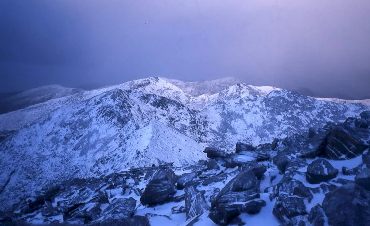
The Clisham (Scottish Gaelic: An Cliseam) is a mountain on North Harris, Lewis and Harris in the Outer Hebrides of Scotland. At 799 metres (2,621 ft), it is the highest mountain in the Outer Hebrides and the archipelago's only Corbett. Climbers often encounter light rain and boggy and muddy terrain. There are a number of paths up to the Clisham's peak. The fastest way to the summit begins at the car park at the bridge along the A859 road between Stornoway and Tarbert and southeast of the mountain. When the visibility is clear, the view from the summit shows all of the Clisham horseshoe peaks: An t-Isean, Mulla bho Dheas, Mulla bho Thuath, and Mullach an Langa. From the southwest side of the peak, Coire Dubh Slabs is visible, and from the north is Aonaig Mhòr. A more advanced hike traverses the Clisham horseshoe beginning at the northern part of the Abhainn Scaladail and moving upstream to the foot of the Mullach an Langa ridge. The distance of the Horseshoe is about 12.5 km. Another advanced path along the horseshoe starts at the northwest along the ridge made by the Mullach an Langa, Mulla-Fo-Thuath and Mulla-Fo-Dheas.
Excerpt from Wikipedia under CC BY-SA 4.0. See the source article linked in Sources below.
- Coordinates
- 57.9637, -6.8126
- Address
- Isle of Harris, Outer Hebrides
- Official site
- www.themountainguide.co.uk
Sources
- osm: n633549042 (ODbL)
- wikipedia: Clisham (CC BY-SA 4.0)
- commons: Clisham.jpg (CC BY-SA 4.0)
Other places nearby
Clisham
Natural landmarks · 0.1 km

An t-Isean
Mountains & hills · 0.9 km

Tomnabhal
Mountains & hills · 1.2 km

Mulla bho Dheas
Mountains & hills · 1.2 km
Mulla bho Dheas
Mountains & hills · 1.2 km

Clisham
Mountains & hills · 1.5 km

Tarsabhal
Mountains & hills · 1.7 km

Mulla bho Thuath
Mountains & hills · 1.8 km

Mulla bho Thuath
Mountains & hills · 1.8 km
Sròn Càrsacleit
Mountains & hills · 2.2 km

Mullach an Langa
Mountains & hills · 2.4 km

Mullach an Langa
Mountains & hills · 2.4 km
Nearby
📷 5Natural landmarks · Scottish Islands
Clisham
Clisham — mountain on the island of Harris in the Western Isles of Scotland.
📷 5Mountains & hills · Scottish Islands
An t-Isean
An t-Isean — mountain in scotland highlands. Elevation: 683 m.
📷 5📷 3Mountains & hills · Scottish Islands
Mulla bho Dheas
Mulla bho Dheas — a mountain in scotland-highlands, United Kingdom.
📷 5Mountains & hills · Scottish Islands
Mulla bho Dheas
Mulla bho Dheas — mountain in scotland highlands. Elevation: 743 m.
📷 5Where to eat & stay near An Cliseam
Places to stay
 📷 5
📷 5Caravan parks · Scottish Islands
Maraig Footpath
Maraig Footpath — a caravan park in scotland highlands.
 📷 5
📷 5Hostels · Scottish Islands
Scaladale centre
Scaladale centre — a hostel in scotland highlands.
 📷 5
📷 5 📷 7
📷 7 📷 5
📷 5Hostels · Scottish Islands
The Back Packers Stop
The Back Packers Stop — a hostel in scotland highlands.
 📷 5
📷 5Hostels · Scottish Islands
Rhenigidale Hostel
Rhenigidale Hostel — a hostel in scotland highlands.
More mountains in this region
 📷 3
📷 3Mountains & hills · Scottish Islands
Acairseid Mhor
Acairseid Mhor — bay in Outer Hebrides, Scotland, UK.
 📷 3
📷 3Mountains & hills · Scottish Islands
Ainshval
Ainshval — Named summit at 781 m.
 📷 3
📷 3 📷 5
📷 5Frequently asked questions
- Where is An Cliseam?
- An Cliseam is in the Scottish Highlands, United Kingdom.
- What is An Cliseam?
- An Cliseam — Named summit at 799 m.
- How do I get to An Cliseam?
- Its coordinates are 57.9637°, -6.8126°.
- Is An Cliseam free to visit?
- Yes, An Cliseam is free to enter.