
Wildlife reserves · East of England
Shotgate Thickets
In or near Rettendon.
Shotgate Thickets — Essex Wildlife Trust Nature reserve.

Wikimedia Commons contributors — see linked file page for photographer and licence licence

Plan your visit
- Typical visit
- 2 h–4 h
- Best time of year
- Autumn & winter (migration & wildfowl)
- Nearest railway station
- Battlesbridge · 1.2 km
- Free entry
- Family-friendly
- Dog-friendly
- Limited wheelchair access
Getting there & planning your visit
To visit Shotgate Thickets, the nearest railway station is Battlesbridge, located 1.2 km away. Entry to the wildlife reserve is free, but wheelchair access is limited. The postcode for sat-nav is SS11 8NT.
About
Shotgate Thickets is a wildlife reserve in the United Kingdom. It covers approximately 3 km². Managed by Essex Wildlife Trust. Wikidata describes it as: "Essex Wildlife Trust Nature reserve". Coordinates: 51.6180°, 0.5530°.
Photo gallery
Summary from the official site
Shotgate Thickets is a small nature reserve located on the north bank of the tidal River Crouch. It features diverse habitats that support a variety of wildlife, including over 70 bird species and numerous damselflies during the summer months.
Read more on the official property page.
From the Wikipedia article
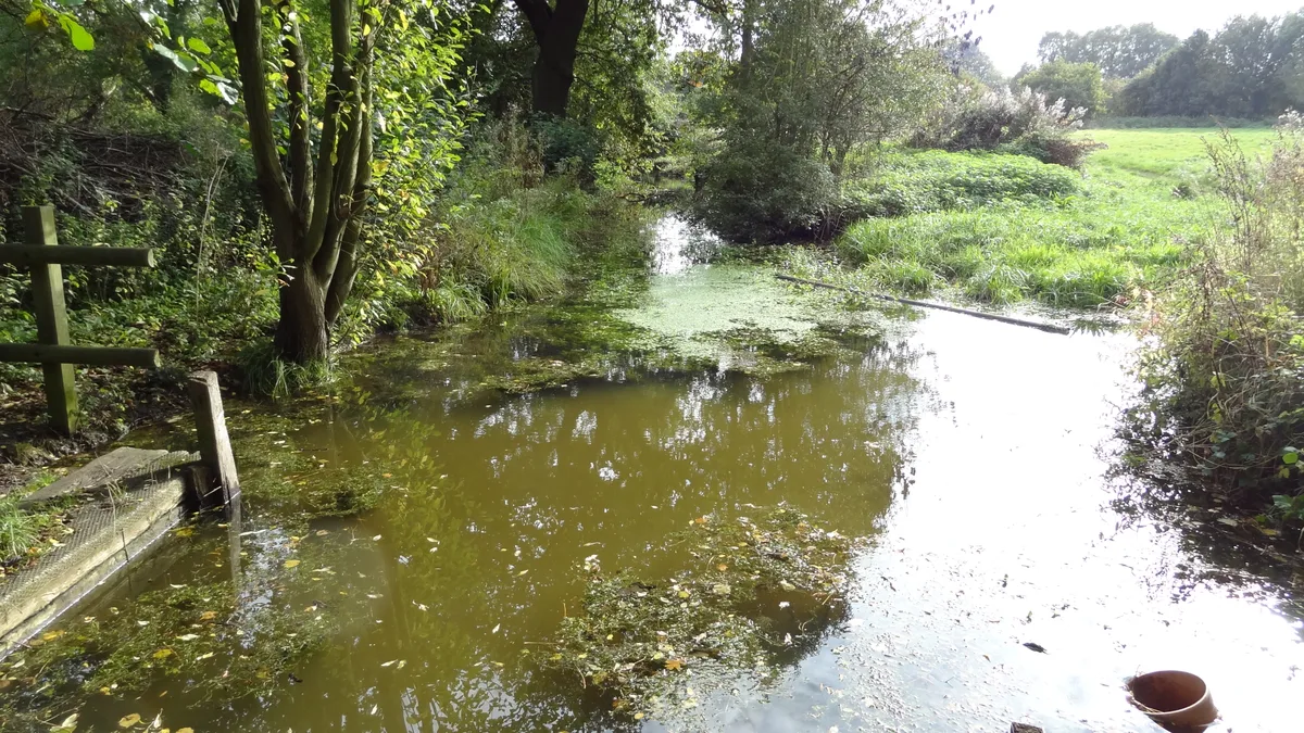
Shotgate Thickets is a 3.2-hectare (7.9-acre) nature reserve east of Wickford in Essex. It is managed by the Essex Wildlife Trust. This site on the north bank of the River Crouch has oak woodland, two ponds, rough grassland and thorn thickets. Fauna include great crested newts, water voles, and over seventy bird species. More than a hundred plant species have been recorded, such as golden dock and dyer's greenweed. There is access by a footpath along the river bank from Battlesbridge.
Excerpt from Wikipedia under CC BY-SA 4.0. See the source article linked in Sources below.
- Coordinates
- 51.6180, 0.5530
- County
- Essex
- District
- Basildon
- Parish
- Wickford
- Postcode
- SS11 8NT
- Parliamentary constituency
- Rayleigh and Wickford
- Phone
- 07876 443304
- Nearest railway station
- Battlesbridge — 1.2 km
- Opening
- Daily 9am–5pm
- Official site
- www.essexwt.org.uk
Sources
- wikidata: Q28405082 (CC0)
- wikipedia: Shotgate Thickets (CC BY-SA 4.0)
- commons: Shotgate Pond - geograph.org.uk - 1253349.jpg (CC BY-SA 4.0)
Other places nearby

Wickford War Memorial
Memorials & monuments · 1.6 km

Rawreth
Villages · 1.8 km

RHS Garden Hyde Hall
Gardens · 1.9 km

Rettendon village sign
Public art & sculpture · 2.0 km

Rettendon
Villages · 2.2 km

Wickford
Museums · 2.3 km
WW1 Memorial
Memorials & monuments · 2.7 km
WW1 Memorial
Memorials & monuments · 2.7 km

War memorials at Dollyman's Farm
Memorials & monuments · 2.7 km

Nevendon
Villages · 3.0 km

Nevendon Manor
Manor houses · 3.7 km

Downham War Memorial
Memorials & monuments · 4.0 km
Nearby
📷 3Memorials & monuments · East of England
Wickford War Memorial
Wickford War Memorial — a memorial in england-east, United Kingdom.
📷 5📷 3Gardens · East of England
RHS Garden Hyde Hall
RHS Essex garden — Britain's driest, with extensive dry-garden plantings.
📷 3Public art & sculpture · East of England
Rettendon village sign
Rettendon village sign — a public art in england-east, United Kingdom.
📷 5📷 5Where to eat & stay near Shotgate Thickets
Places to stay
 📷 5
📷 5 📷 5
📷 5 📷 5
📷 5Campsites · East of England
Belchamps Scout Activity Centre
Belchamps Scout Activity Centre — a campsite in england south east.
 📷 5📷 5
Campsites · East of England
The Lake at Nine Acres
The Lake at Nine Acres — a campsite in england south east.
 📷 5
📷 5Campsites · East of England
Ark Lane Scout Campsite
Ark Lane Scout Campsite — a campsite in england south east.
Places to eat & drink
 📷 5
📷 5Historic pubs · East of England
The Crown Public House
The Crown Public House in England South East, United Kingdom.
 📷 5
📷 5Historic pubs · East of England
The Old White Horse Public House
The Old White Horse Public House in England South East, United Kingdom.
 📷 5
📷 5 📷 5
📷 5Historic pubs · East of England
The Anchor Inn And Building Attached To Right
The Anchor Inn And Building Attached To Right in England South East, United Kingdom.
 📷 5
📷 5Historic pubs · East of England
The Half Crown Inn
The Half Crown Inn in England South East, United Kingdom.
 📷 5
📷 5Historic pubs · East of England
Bell House Public House
Bell House Public House in England South East, United Kingdom.
More places run by Essex Wildlife Trust
 Flagship📷 10
Wildlife reserves · London
Bedfords Park
Bedfords Park — Havering London Borough green landscape, also an Essex Wildlife Trust Nature reserve.
 Flagship📷 10
Wildlife reserves · London
Chafford Gorges Nature Park
Chafford Gorges Nature Park — Essex Wildlife Trust Nature reserve.
 Flagship📷 10
Wildlife reserves · London
Cranham Marsh
Cranham Marsh — Essex Wildlife Trust Nature reserve in the London Borough of Havering, England, UK.
 Flagship📷 10
Wildlife reserves · London
Gernon Bushes
Gernon Bushes — Essex Wildlife Trust Nature reserve.
More places in this region
 Flagship📷 10
Wildlife reserves · East of England
Amwell Quarry
Amwell Quarry — nature reserve in United Kingdom.
 Flagship📷 10
Wildlife reserves · East of England
Aubrey Buxton Nature Reserve
Aubrey Buxton Nature Reserve — Essex Wildlife Trust Nature reserve.
 Flagship📷 10
Wildlife reserves · East of England
Canvey Wick
Canvey Wick — nature reserve in Essex, United Kingdom.
 Flagship📷 10
Wildlife reserves · East of England
Crowsheath Wood
Crowsheath Wood — Essex Wildlife Trust Nature reserve.
Frequently asked questions
- Where is Shotgate Thickets?
- Shotgate Thickets is in Essex, East of England, United Kingdom (postcode SS11 8NT), in the parish of Wickford.
- What is Shotgate Thickets?
- Shotgate Thickets — Essex Wildlife Trust Nature reserve.
- How do I get to Shotgate Thickets?
- The nearest railway station is Battlesbridge, about 1.2 km away. The nearest town is Rettendon. Drivers can use postcode SS11 8NT.
- Who runs Shotgate Thickets?
- Shotgate Thickets is operated by Essex Wildlife Trust.
- Is Shotgate Thickets free to visit?
- Yes, Shotgate Thickets is free to enter.
- How do I get to Shotgate Thickets?
- The nearest railway station is Battlesbridge, about 1.2 km away. Drivers can navigate to postcode SS11 8NT.
- Are dogs allowed at Shotgate Thickets?
- Most wildlife reserves allow dogs on lead only, with restrictions during ground-nesting bird season (March-July). Check signage at the reserve.