Mountains & hills · Scottish Highlands
Sgurr a' Chaorainn
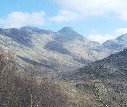
Sgurr a' Chaorainn — a hill or mountain in scotland highlands.

Trevor Littlewood — CC BY-SA 2.0 via Wikimedia Commons licence
Plan your visit
- Typical visit
- 3 h–8 h
- Best time of year
- Late spring – early autumn (May–Oct)
About
A British hill or mountain, named on Ordnance Survey maps and walked by hill-baggers. Sgurr a' Chaorainn is a named hill or mountain in scotland highlands, recorded in the GeoNames UK gazetteer. British landmarks of this type are typically marked on Ordnance Survey maps and recorded in the national gazetteer for cartographic and navigational reference. Coordinates and feature classification are sourced from the GeoNames open dataset.
Photo gallery
Place summary
Sgurr a' Chaorainn is a mountain located in the Scottish Highlands. This peak is part of the Monadhliath range, known for its rugged terrain and scenic views. The area offers opportunities for hiking and wildlife observation, appealing to outdoor enthusiasts. Its remote setting provides a sense of solitude typical of the Highlands.
AI-generated from the structured facts on this page (operator, designation, listing, era). Not a substitute for visiting.
- Coordinates
- 56.7398, -5.4435
Sources
- manual: geonames-12607519 (CC BY 4.0)
Other places nearby
Loading nearby places…
Nearby
📷 5Mountains & hills · Scottish Highlands
Sgùrr a' Chaorainn
Sgùrr a' Chaorainn — mountain in scotland highlands. Elevation: 761 m.
 📷 5
📷 5Mountains & hills · Scottish Highlands
Sgurr na Laire
Sgurr na Laire — a hill or mountain in scotland highlands.
📷 5Mountains & hills · Scottish Highlands
Sgurr na h-Ighinn
Sgurr na h-Ighinn — a hill or mountain in scotland highlands.
📷 5Mountains & hills · Scottish Highlands
Sgùrr na h-Ighinn
Sgùrr na h-Ighinn — mountain in scotland highlands. Elevation: 766 m.
 📷 3
📷 3Natural landmarks · Scottish Highlands
Sgùrr Dhomhnuill
Sgùrr Dhomhnuill — mountain in Highland, Scotland, UK.
📷 5Mountains & hills · Scottish Highlands
Sgurr Dhomhnuill
Sgurr Dhomhnuill — a hill or mountain in scotland highlands.
Where to eat & stay near Sgurr a' Chaorainn
Places to stay
 📷 5
📷 5Hostels · Scottish Highlands
Ariundle Centre
Ariundle Centre — a hostel in scotland highlands.
 📷 5
📷 5Campsites · Scottish Highlands
Sunart Camping
Sunart Camping — a campsite in scotland highlands.
 📷 5
📷 5Hotels · Scottish Highlands
The Strontian Hotel
The Strontian Hotel — a hotel in scotland highlands.
 📷 5
📷 5Hostels · Scottish Highlands
Corran Bunkhouse
Corran Bunkhouse — a hostel in scotland highlands.
 📷 5
📷 5Caravan parks · Scottish Highlands
Bunree Caravan Club Site
Bunree Caravan Club Site — a caravan park in scotland highlands.
 📷 5
📷 5Campsites · Scottish Highlands
Lagnaha Farm
Lagnaha Farm — a campsite in scotland highlands.

More mountains in this region
 📷 3
📷 3Mountains & hills · Scottish Highlands
A' Bhuidheanach Bheag
A' Bhuidheanach Bheag — Named summit at 936 m.
 📷 3
📷 3Mountains & hills · Scottish Highlands
A' Chailleach
A' Chailleach — Named summit at 997 m.
 📷 3
📷 3Mountains & hills · Scottish Highlands
A' Chailleach
A' Chailleach — Named summit at 930 m.
 📷 3
📷 3Mountains & hills · Scottish Highlands
A' Chaoirnich
A' Chaoirnich — Named summit at 875 m.
Frequently asked questions
- Where is Sgurr a' Chaorainn?
- Sgurr a' Chaorainn is in the Scottish Highlands, United Kingdom.
- What is Sgurr a' Chaorainn?
- Sgurr a' Chaorainn — a hill or mountain in scotland highlands.
- How do I get to Sgurr a' Chaorainn?
- Its coordinates are 56.7398°, -5.4435°.