Mountains & hills · Scottish Highlands
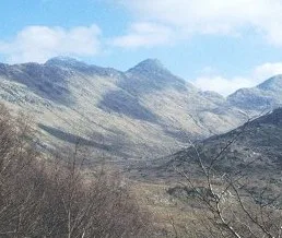
Sgùrr na h-Ighinn
Sgùrr na h-Ighinn — mountain in scotland highlands. Elevation: 766 m.

Trevor Littlewood — CC BY-SA 2.0 via Wikimedia Commons licence
Plan your visit
- Typical visit
- 3 h–8 h
- Best time of year
- Late spring – early autumn (May–Oct)
About
Sgùrr na h-Ighinn is a mountain located in scotland highlands. Elevation: 766 m. A named British peak recorded in OpenStreetMap. Peaks are typically named on Ordnance Survey 1:50k mapping.
Photo gallery
Place summary
Sgùrr na h-Ighinn is a mountain located in the Scottish Highlands. It is part of the Cuillin range on the Isle of Skye. Known for its rugged terrain and dramatic scenery, it attracts climbers and hikers seeking challenging routes and panoramic views. The mountain's distinctive features contribute to its appeal within the region's natural landscape.
AI-generated from the structured facts on this page (operator, designation, listing, era). Not a substitute for visiting.
- Coordinates
- 56.7467, -5.4578
Sources
- osm: n2723840504 (ODbL)
Other places nearby
Loading nearby places…
Nearby
📷 5Mountains & hills · Scottish Highlands
Sgurr na h-Ighinn
Sgurr na h-Ighinn — a hill or mountain in scotland highlands.
 📷 3
📷 3Natural landmarks · Scottish Highlands
Sgùrr Dhomhnuill
Sgùrr Dhomhnuill — mountain in Highland, Scotland, UK.
📷 5Mountains & hills · Scottish Highlands
Sgurr Dhomhnuill
Sgurr Dhomhnuill — a hill or mountain in scotland highlands.
 📷 3
📷 3Mountains & hills · Scottish Highlands
Sgùrr Dhòmhnuill
Sgùrr Dhòmhnuill — Named summit at 888 m.
📷 5Mountains & hills · Scottish Highlands
Sgùrr a' Chaorainn
Sgùrr a' Chaorainn — mountain in scotland highlands. Elevation: 761 m.
📷 5Mountains & hills · Scottish Highlands
Sgurr a' Chaorainn
Sgurr a' Chaorainn — a hill or mountain in scotland highlands.
Where to eat & stay near Sgùrr na h-Ighinn
Places to stay
 📷 5
📷 5Hostels · Scottish Highlands
Ariundle Centre
Ariundle Centre — a hostel in scotland highlands.
 📷 5
📷 5Campsites · Scottish Highlands
Sunart Camping
Sunart Camping — a campsite in scotland highlands.
 📷 5
📷 5Hotels · Scottish Highlands
The Strontian Hotel
The Strontian Hotel — a hotel in scotland highlands.
 📷 5
📷 5Hostels · Scottish Highlands
Corran Bunkhouse
Corran Bunkhouse — a hostel in scotland highlands.
 📷 5
📷 5Hostels · Scottish Highlands
The Sleeping Car
The Sleeping Car — a hostel in scotland highlands.
 📷 5
📷 5Caravan parks · Scottish Highlands
Bunree Caravan Club Site
Bunree Caravan Club Site — a caravan park in scotland highlands.
More mountains in this region
 📷 3
📷 3Mountains & hills · Scottish Highlands
A' Bhuidheanach Bheag
A' Bhuidheanach Bheag — Named summit at 936 m.
 📷 3
📷 3Mountains & hills · Scottish Highlands
A' Chailleach
A' Chailleach — Named summit at 997 m.
 📷 3
📷 3Mountains & hills · Scottish Highlands
A' Chailleach
A' Chailleach — Named summit at 930 m.
 📷 3
📷 3Mountains & hills · Scottish Highlands
A' Chaoirnich
A' Chaoirnich — Named summit at 875 m.
Frequently asked questions
- Where is Sgùrr na h-Ighinn?
- Sgùrr na h-Ighinn is in the Scottish Highlands, United Kingdom.
- What is Sgùrr na h-Ighinn?
- Sgùrr na h-Ighinn — mountain in scotland highlands. Elevation: 766 m.
- How do I get to Sgùrr na h-Ighinn?
- Its coordinates are 56.7467°, -5.4578°.