Mountains & hills · Scottish Highlands
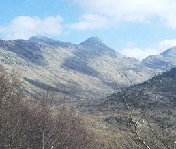
Sgùrr a' Chaorainn
Sgùrr a' Chaorainn — mountain in scotland highlands. Elevation: 761 m.

Trevor Littlewood — CC BY-SA 2.0 via Wikimedia Commons licence
Plan your visit
- Typical visit
- 3 h–8 h
- Best time of year
- Late spring – early autumn (May–Oct)
About
Sgùrr a' Chaorainn is a mountain located in scotland highlands. Elevation: 761 m. A named British peak recorded in OpenStreetMap. Peaks are typically named on Ordnance Survey 1:50k mapping.
Photo gallery
Place summary
Sgùrr a' Chaorainn is a mountain located in the Scottish Highlands. It is known for its rugged terrain and striking views of the surrounding landscape. The peak attracts hikers and climbers looking for a challenging ascent and a chance to experience the natural beauty of the Highlands. The area is characterised by its dramatic scenery and diverse wildlife.
AI-generated from the structured facts on this page (operator, designation, listing, era). Not a substitute for visiting.
- Coordinates
- 56.7395, -5.4454
Sources
- osm: n2723840501 (ODbL)
Other places nearby
Loading nearby places…
Nearby
📷 5Mountains & hills · Scottish Highlands
Sgurr a' Chaorainn
Sgurr a' Chaorainn — a hill or mountain in scotland highlands.
 📷 5
📷 5Mountains & hills · Scottish Highlands
Sgurr na Laire
Sgurr na Laire — a hill or mountain in scotland highlands.
📷 5Mountains & hills · Scottish Highlands
Sgurr na h-Ighinn
Sgurr na h-Ighinn — a hill or mountain in scotland highlands.
📷 5Mountains & hills · Scottish Highlands
Sgùrr na h-Ighinn
Sgùrr na h-Ighinn — mountain in scotland highlands. Elevation: 766 m.
 📷 3
📷 3Natural landmarks · Scottish Highlands
Sgùrr Dhomhnuill
Sgùrr Dhomhnuill — mountain in Highland, Scotland, UK.
📷 5Mountains & hills · Scottish Highlands
Sgurr Dhomhnuill
Sgurr Dhomhnuill — a hill or mountain in scotland highlands.
Where to eat & stay near Sgùrr a' Chaorainn
Places to stay
 📷 5
📷 5Hostels · Scottish Highlands
Ariundle Centre
Ariundle Centre — a hostel in scotland highlands.
 📷 5
📷 5Campsites · Scottish Highlands
Sunart Camping
Sunart Camping — a campsite in scotland highlands.
 📷 5
📷 5Hotels · Scottish Highlands
The Strontian Hotel
The Strontian Hotel — a hotel in scotland highlands.
 📷 5
📷 5Hostels · Scottish Highlands
Corran Bunkhouse
Corran Bunkhouse — a hostel in scotland highlands.
 📷 5
📷 5Caravan parks · Scottish Highlands
Bunree Caravan Club Site
Bunree Caravan Club Site — a caravan park in scotland highlands.
 📷 5
📷 5Campsites · Scottish Highlands
Lagnaha Farm
Lagnaha Farm — a campsite in scotland highlands.

More mountains in this region
 📷 3
📷 3Mountains & hills · Scottish Highlands
A' Bhuidheanach Bheag
A' Bhuidheanach Bheag — Named summit at 936 m.
 📷 3
📷 3Mountains & hills · Scottish Highlands
A' Chailleach
A' Chailleach — Named summit at 997 m.
 📷 3
📷 3Mountains & hills · Scottish Highlands
A' Chailleach
A' Chailleach — Named summit at 930 m.
 📷 3
📷 3Mountains & hills · Scottish Highlands
A' Chaoirnich
A' Chaoirnich — Named summit at 875 m.
Frequently asked questions
- Where is Sgùrr a' Chaorainn?
- Sgùrr a' Chaorainn is in the Scottish Highlands, United Kingdom.
- What is Sgùrr a' Chaorainn?
- Sgùrr a' Chaorainn — mountain in scotland highlands. Elevation: 761 m.
- How do I get to Sgùrr a' Chaorainn?
- Its coordinates are 56.7395°, -5.4454°.