Mountains & hills · Scottish Lowlands
Setrah Hill
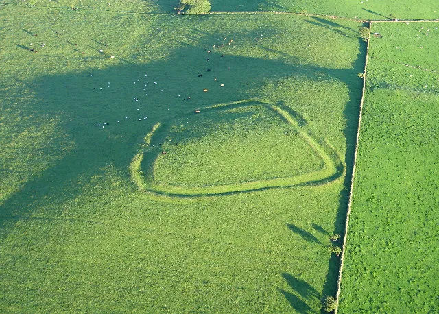
Setrah Hill — mountain in scotland lowlands. Elevation: 202 m.

Christine Johnstone — CC BY-SA 2.0 via Wikimedia Commons licence
Plan your visit
- Typical visit
- 3 h–8 h
- Best time of year
- Late spring – early autumn (May–Oct)
About
Setrah Hill is a mountain located in scotland lowlands. Elevation: 202 m. A named British peak recorded in OpenStreetMap. Peaks are typically named on Ordnance Survey 1:50k mapping.
Photo gallery
Place summary
Setrah Hill is a mountain located in the Scottish Lowlands. It offers a rugged landscape typical of the region, characterised by rolling hills and scenic views. The area is suitable for various outdoor activities, including hiking and wildlife observation. Visitors can expect a tranquil environment, away from urban noise, ideal for enjoying nature.
AI-generated from the structured facts on this page (operator, designation, listing, era). Not a substitute for visiting.
- Coordinates
- 54.7168, -3.2686
Sources
- osm: n5130368235 (ODbL)
Other places nearby
Loading nearby places…
Nearby
 📷 4
📷 4Caravan parks · Scottish Lowlands
Skiddaw View Holiday Park
Skiddaw View Holiday Park — a caravan park in scotland lowlands.
 📷 5
📷 5Mountains & hills · Scottish Lowlands
Sunderland Heads
Sunderland Heads — mountain in scotland lowlands. Elevation: 226.8 m.
 📷 5
📷 5Mountains & hills · Scottish Lowlands
Caermote Hill
Caermote Hill — a hill or mountain in scotland lowlands.
 📷 3
📷 3Mountains & hills · Scottish Lowlands
Caer Mote
Caer Mote — Named summit at 289 m.
 📷 5
📷 5Mountains & hills · Scottish Lowlands
Wharrels Hill
Wharrels Hill — mountain in scotland lowlands. Elevation: 223 m.
 📷 5
📷 5Mountains & hills · Scottish Lowlands
Caer Mot
Caer Mot — mountain in scotland lowlands. Elevation: 285 m.
Where to eat & stay near Setrah Hill
Places to stay
📷 4Caravan parks · Scottish Lowlands
Skiddaw View Holiday Park
Skiddaw View Holiday Park — a caravan park in scotland lowlands.
 📷 5
📷 5Campsites · Scottish Lowlands
Linskeldfield Farm Camping
Linskeldfield Farm Camping — a campsite in scotland lowlands.

Caravan parks · Scottish Lowlands
Keswick Lodge Retreat
Keswick Lodge Retreat — a caravan park in scotland lowlands.

Caravan parks · Scottish Lowlands
Threapland Park
Threapland Park — a caravan park in scotland lowlands.
 📷 5
📷 5Caravan parks · Scottish Lowlands
Coal Beck Caravan Park
Coal Beck Caravan Park — a caravan park in scotland lowlands.
 📷 5
📷 5Caravan parks · Scottish Lowlands
Herdwick Croft Caravan Park
Herdwick Croft Caravan Park — a caravan park in scotland lowlands.
Places to eat & drink
 📷 5
📷 5Historic pubs · Scottish Lowlands
The Pheasant Inn
The Pheasant Inn in Scotland Lowlands, United Kingdom.
 📷 5
📷 5Historic pubs · Scottish Lowlands
Kings Arms Walter Willsons
Kings Arms Walter Willsons in Scotland Lowlands, United Kingdom.
 📷 4
📷 4Historic pubs · Scottish Lowlands
Oddfellows Arms
Oddfellows Arms — Historic pub — listed building or notable heritage status.
 📷 5
📷 5Cafés · Scottish Lowlands
YHA Cafe
YHA Cafe — a café in scotland lowlands.
 📷 5
📷 5Cafés · North East England
Grange Bridge Cottage
Grange Bridge Cottage — a café in england north east.
 📷 5
📷 5Cafés · Scottish Lowlands
Crumbs
Crumbs — a café in scotland lowlands.
More mountains in this region
 📷 3
📷 3Mountains & hills · Scottish Lowlands
Andrewhinney Hill
Andrewhinney Hill — Named summit at 677 m.
 📷 3
📷 3Mountains & hills · Scottish Lowlands
Arbory Hill
Arbory Hill — Named summit at 429 m.
 📷 3
📷 3Mountains & hills · Scottish Lowlands
Auchenton Hill ( East Mount Lowther)
Auchenton Hill ( East Mount Lowther) — Named summit at 631 m.
 📷 3
📷 3Mountains & hills · Scottish Lowlands
Bakestall
Bakestall — Named summit at 673.5 m.
Frequently asked questions
- Where is Setrah Hill?
- Setrah Hill is in the Scottish Lowlands, United Kingdom.
- What is Setrah Hill?
- Setrah Hill — mountain in scotland lowlands. Elevation: 202 m.
- How do I get to Setrah Hill?
- Its coordinates are 54.7168°, -3.2686°.