
Natural landmarks · North East England
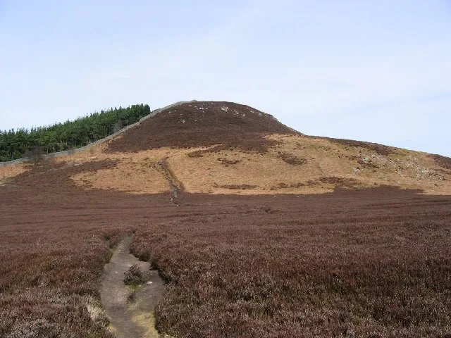
Ros Hill
In or near Chillingham.
Ros Hill — mountain in United Kingdom.

Wikimedia Commons contributors — see linked file page for photographer and licence licence

Plan your visit
- Typical visit
- 1 h–2 h
- Free entry
- Dog-friendly
About
Ros Hill is a named natural landmark in the United Kingdom. Wikidata describes it as: "mountain in United Kingdom". Coordinates: 55.5214°, -1.8733°.
Photo gallery
Protected designations
- Site of Special Scientific Interest: Bewick and Beanley Moors SSSI
- Site of Special Scientific Interest: Northumberland Shore SSSI
- Area of Outstanding Natural Beauty: Northumberland Coast
Designations sourced from Natural England open data under OGL v3.
From the Wikipedia article
Ros Hill, also known as Ros Castle due to the 3,000-year-old Iron Age hillfort, a 1.2-hectare (3-acre) scheduled monument on its summit, is a hill in the county of Northumberland in northern England. It is the highest point of a low range of hills stretching from Alnwick to Berwick-upon-Tweed — the Chillingham Hills. Other tops of the Chillingham Hills include Titlington Pike, Dod Law and Doddington Northmoor. However, Ros Hill is significantly higher than these and towers over the surrounding landscape with easily enough relative height to make it a "Marilyn". Ros Hill is situated just above Chillingham, with its famous herd of Chillingham cattle. Due to the wide enclosure of the cattle there are no paths on the western slopes, and the eastern slopes are featureless moor, so the best ascent option is to park at the summit of the minor road that crosses Hepburn Moor just to the south of the summit, giving a walk just over half a mile long and taking about half an hour. The summit is marked by a triangulation station and nearby there is a rather unusual walk-in toposcope built into the wall with four separate plaques. The view is panoramic and very extensive, and on a clear day, a total of seven castles can be seen from the summit, including the one on Holy Island. There is also a view over the cattle park to the north, while purple heather covers most of the surrounding area. This was a favourite location of Sir Edward Grey and after his death a part of the hill was acquired by public subscription and presented to the National Trust as part of a memorial to Grey. A plaque on the triangulation pillar records this.
Excerpt from Wikipedia under CC BY-SA 4.0. See the source article linked in Sources below.
- Coordinates
- 55.5214, -1.8733
- District
- Northumberland
- Parish
- Chillingham
- Postcode
- NE66 4EG
- Parliamentary constituency
- North Northumberland
Sources
- wikidata: Q7366977 (CC0)
- wikipedia: Ros Hill (CC BY-SA 4.0)
- commons: Ros Hill.jpg (CC BY-SA 4.0)
Other places nearby

Ros Castle fort
Castles · 0.0 km
Ros Castle
Mountains & hills · 0.0 km

Univallate hillfort, 560m south west of Shepherd's Cairn
Vineyards · 0.0 km

Hepburn Crags
Mountains & hills · 0.7 km

Chillingham cattle
Castles · 0.8 km

Promontory fort, 551m east of Hepburn Cottage
Vineyards · 0.9 km

Bridge Circa 200 Yards West Of Botany
Historic bridges · 1.0 km

Hepburn Castle
Castles · 1.1 km
Hepburn Bastle
Historic houses · 1.1 km

Hepburn Bastle
Literary houses · 1.1 km

Cyst and Capstone
Follies · 1.3 km

Willie Law
Mountains & hills · 1.6 km
Nearby
📷 3Castles · North East England
Ros Castle fort
Ros Castle fort — a castle in scotland-central, United Kingdom.
📷 3📷 5Vineyards · North East England
Univallate hillfort, 560m south west of Shepherd's Cairn
Univallate hillfort, 560m south west of Shepherd's Cairn — a UK vineyard in scotland central, producing English or Welsh wine from cool-climate grape varieties.
📷 5Mountains & hills · North East England
Hepburn Crags
Hepburn Crags — mountain in scotland central. Elevation: 277 m.
📷 5Castles · North East England
Chillingham cattle
Chillingham cattle, also known as Chillingham wild cattle, is a breed of cattle that live in a large enclosed park at Chillingham Castle, Northumberland, England. In summer 2022 the cattle number 138
📷 5Vineyards · North East England
Promontory fort, 551m east of Hepburn Cottage
Promontory fort, 551m east of Hepburn Cottage — a UK vineyard in scotland central, producing English or Welsh wine from cool-climate grape varieties.
Where to eat & stay near Ros Hill
Places to stay
 📷 5
📷 5Caravan parks · North East England
Adderstone Caravan Park
Adderstone Caravan Park — a caravan park in scotland central.
 📷 5
📷 5Campsites · North East England
Powburn Scout Adventure Centre
Powburn Scout Adventure Centre — a campsite in scotland lowlands.
 📷 5
📷 5Caravan parks · North East England
South Meadows Caravan Park
South Meadows Caravan Park — a caravan park in scotland central.
 📷 5
📷 5Caravan parks · North East England
Orchard Caravan Park
Orchard Caravan Park — a caravan park in scotland central.
 📷 5
📷 5Caravan parks · North East England
Bridgend Park
Bridgend Park — a caravan park in scotland central.
📷 5Caravan parks · North East England
Riverside Leisure Park
Riverside Leisure Park — a caravan park in scotland central.
Places to eat & drink
 📷 7
📷 7Historic pubs · North East England
Plough Inn With Outbuilding To North
Plough Inn With Outbuilding To North in Scotland Lowlands, United Kingdom.
 📷 7
📷 7 📷 7
📷 7Historic pubs · North East England
Bridge Of Aln Hotel
Bridge Of Aln Hotel in Scotland Lowlands, United Kingdom.
 📷 7
📷 7Historic pubs · North East England
Black Swan Public House
Black Swan Public House in Scotland Lowlands, United Kingdom.
 📷 7
📷 7 📷 5
📷 5More natural landmarks in this region
 📷 4
📷 4Natural landmarks · North East England
Cleveland Way
109-mile horseshoe trail around the North York Moors and its sea cliffs.
 📷 3
📷 3Natural landmarks · North East England
The Hand Stone
The Hand Stone — a other in england-yorkshire, United Kingdom.
 📷 3
📷 3Natural landmarks · North East England
The Face Stone
The Face Stone — a other in england-yorkshire, United Kingdom.
 📷 3
📷 3Frequently asked questions
- Where is Ros Hill?
- Ros Hill is in North-East England, United Kingdom (postcode NE66 4EG), in the parish of Chillingham.
- What is Ros Hill?
- Ros Hill — mountain in United Kingdom.
- How do I get to Ros Hill?
- The nearest town is Chillingham. Drivers can use postcode NE66 4EG.
- Is Ros Hill a protected site?
- Yes — Ros Hill is part of the Bewick and Beanley Moors SSSI Site of Special Scientific Interest and the Northumberland Shore SSSI Site of Special Scientific Interest.
- Is Ros Hill free to visit?
- Yes, Ros Hill is free to enter.
- How do I get to Ros Hill?
- Drivers can navigate to postcode NE66 4EG. It sits within the North Northumberland parliamentary constituency.