
Historic churches · North Wales
Rhosybol
Rhosybol (Welsh for 'moor in the hollow') is a village and community in Anglesey, Wales. The community population at the 2011 census was 1,078. Located 2.5 miles (4.0 km) south of the town of Amlwch,

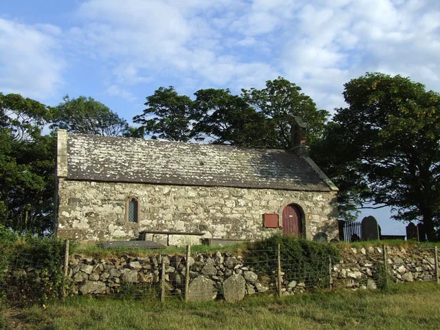
Eric Jones — CC BY-SA 2.0 via Wikimedia Commons licence

Plan your visit
- Typical visit
- 30 min–1 h
- Free entry
About
Rhosybol (Welsh for 'moor in the hollow') is a village and community in Anglesey, Wales. The community population at the 2011 census was 1,078. Located 2.5 miles (4.0 km) south of the town of Amlwch, the village is close to both Llyn Alaw, the largest body of water on the island, and Parys Mountain, the site of the historic copper mines which lies just to the north. It is to the mines that the village owes its existence as it was one of several built to house the miners. During the 1960s noted painter Kyffin Williams produced an oil painting of the village. Rhosybol lies on the B5111 road from Amlwch to Llannerch-y-medd. Just to the east of the village is the Trysglwyn Wind Farm. This site covers an area of about 100 hectares (250 acres) and is operated by RWE Innogy International. Much of the land is pasture where livestock can graze to the foot of the turbines. A pond has been provided and patches of woodland have been planted to enhance the wildlife value of the site. An information board is situated at the site entrance about 250 metres (270 yd) southeast of the farm of Trysglwyn Fawr. Rhosybol has a Post office which is incorporated within its small corner shop. There is also a primary school for boys and girls between the ages of 4 and 11, in the playground of which is the village's war memorial clock tower. The memorial is unusual in that it only shows the names of those who fell in the First World War and not those in the Second. The village church is named Christ Chu
Photo gallery
From the Wikipedia article
Rhosybol (Welsh for 'moor in the hollow') is a village and community in Anglesey, Wales. The community population at the 2011 census was 1,078. Located 2.5 miles (4.0 km) south of the town of Amlwch, the village is close to both Llyn Alaw, the largest body of water on the island, and Parys Mountain, the site of the historic copper mines which lies just to the north. It is to the mines that the village owes its existence as it was one of several built to house the miners. During the 1960s noted painter Kyffin Williams produced an oil painting of the village. Rhosybol lies on the B5111 road from Amlwch to Llannerch-y-medd. Just to the east of the village is the Trysglwyn Wind Farm. This site covers an area of about 100 hectares (250 acres) and is operated by RWE Innogy International. Much of the land is pasture where livestock can graze to the foot of the turbines. A pond has been provided and patches of woodland have been planted to enhance the wildlife value of the site. An information board is situated at the site entrance about 250 metres (270 yd) southeast of the farm of Trysglwyn Fawr. Rhosybol has a Post office which is incorporated within its small corner shop. There is also a primary school for boys and girls between the ages of 4 and 11, in the playground of which is the village's war memorial clock tower. The memorial is unusual in that it only shows the names of those who fell in the First World War and not those in the Second. The village church is named Christ Church and is now disused, and so is the chapel named Bethania, but a further chapel named Capel Gorslwyd is still open and here services are still held. The village sits on the north east of Anglesey. There is a Welsh-medium primary school, Ysgol Gynradd Rhosybol, located in the village. As of January 2018, the school had the second highest percentage of pupils (aged 5 and over) who spoke Welsh at home in Anglesey, at 79%. Villages and hamlets in the community include Llandyfrydog, Rhosgoch, Penb
Excerpt from Wikipedia under CC BY-SA 4.0. See the source article linked in Sources below.
- Coordinates
- 53.3680, -4.3680
- District
- Isle of Anglesey
- Parish
- Rhosybol
- Postcode
- LL68 9TT
- Parliamentary constituency
- Ynys Môn
Sources
- wikipedia: Rhosybol (CC BY-SA 4.0)
Other places nearby

Penyfynwent
Archaeological sites · 1.0 km

Rhosgoch
Historic churches · 1.8 km

The Ring
Caravan parks · 1.9 km

Parys Mountain View
Viewpoints · 2.3 km

Capel Parc
Other places · 2.5 km

Bodewryd Standing Stone
Windmills · 2.7 km

Parys Mountain Copper Mines (pits, opencast and spoil areas)
Archaeological sites · 2.8 km

Parys Mountain
Mountains & hills · 2.8 km

Parys Mountain Windmill
Windmills · 2.8 km

Gwredog
Villages · 2.9 km
St Ceidio's Church
Historic churches · 3.1 km

Pearl Engine House
Historic houses · 3.3 km
Nearby
📷 3Archaeological sites · North Wales
Penyfynwent
Penyfynwent — a archaeological in wales-north, United Kingdom.
📷 5Historic churches · North Wales
Rhosgoch
Rhosgoch (; meaning: 'red moor') is a small village in the north of the island of Anglesey, Wales, about 3.5 miles (5.6 km) to the south-west of Amlwch. It is in the community of Rhosybol. A short dis
📷 5📷 3Viewpoints · North Wales
Parys Mountain View
Parys Mountain View is a viewpoint in the United Kingdom.
📷 5📷 5Windmills · North Wales
Bodewryd Standing Stone
Bodewryd Standing Stone — a post mill in wales-north, United Kingdom.
Where to eat & stay near Rhosybol
Places to stay
📷 5 📷 5
📷 5 📷 5
📷 5 📷 5
📷 5Hotels · North Wales
Dinorben Arms
Dinorben Arms — a hotel in wales north.
 📷 5
📷 5Caravan parks · North Wales
Tyddyn Isaf Caravan Park
Tyddyn Isaf Caravan Park — a caravan park in wales north.
 📷 5
📷 5Caravan parks · North Wales
Minffordd Caravan Park
Minffordd Caravan Park — a caravan park in wales north.
Places to eat & drink
 📷 5
📷 5Historic pubs · North Wales
The Kings Head Hotel
The Kings Head Hotel in Wales North, United Kingdom.
 📷 5
📷 5Historic pubs · North Wales
The Bull Hotel, Llangefni
The Bull Hotel, Llangefni in Wales North, United Kingdom.
 📷 5
📷 5 📷 5
📷 5Restaurants · North Wales
Oyster Catcher
Oyster Catcher — a restaurant in wales north.
 📷 5
📷 5Historic pubs · North Wales
The George and Dragon
The George and Dragon — Historic pub — listed building or notable heritage status.
 📷 7
📷 7More places in this region
 📷 3
📷 3Historic churches · North Wales
All Saints Church
All Saints Church — Anglican church in Deganwy, Wales.
 📷 3
📷 3Historic churches · North Wales
All Saints Church, Great Saughall
All Saints Church, Great Saughall — grade II listed church in Saughall, Cheshire West and Chester, Cheshire, England, UK.
 📷 3
📷 3Historic churches · North Wales
All Saints Church, Higher Kinnerton
All Saints Church, Higher Kinnerton — church in United Kingdom.
 📷 3
📷 3Historic churches · North Wales
All Saints' Church, Gresford
All Saints' Church, Gresford — church in Gresford, north Wales.
Frequently asked questions
- Where is Rhosybol?
- Rhosybol is in North Wales, United Kingdom (postcode LL68 9TT), in the parish of Rhosybol.
- What is Rhosybol?
- Rhosybol (Welsh for 'moor in the hollow') is a village and community in Anglesey, Wales. The community population at the 2011 census was 1,078. Located 2.5 miles (4.0 km) south of the town of Amlwch,
- How do I get to Rhosybol?
- Drivers can use postcode LL68 9TT.
- Is Rhosybol free to visit?
- Yes, Rhosybol is free to enter.
- How do I get to Rhosybol?
- Drivers can navigate to postcode LL68 9TT. It sits within the Ynys Môn parliamentary constituency.