
Museums · East of England
Reepham, Norfolk
In or near Booton.
Reepham () is a market town and civil parish in the Broadland district of Norfolk, England. The town is on the B1145 road between the Bure and Wensum valleys, and is 12 miles (19 km) northwest of Norw

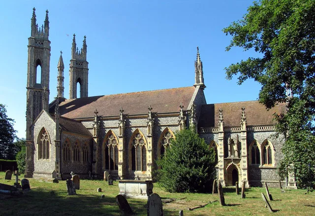
Evelyn Simak — CC BY-SA 2.0 via Wikimedia Commons licence

Plan your visit
- Typical visit
- 1.5 h–3 h
- Best time of year
- Year-round
- Free entry
- Family-friendly
- Limited wheelchair access
About
Reepham () is a market town and civil parish in the Broadland district of Norfolk, England. The town is on the B1145 road between the Bure and Wensum valleys, and is 12 miles (19 km) northwest of Norwich. At the time of the 2001 census the civil parish (including Pettywell) had a population of 2,455 residents in 970 households, occupying an area of 1,909 hectares (4,720 acres), increasing to a population of 2,709 in 1,169 households at the 2011 census.
Photo gallery
Official information
The ruins of All Saints' Church in Hackford, Reepham, are remnants of a medieval church that was destroyed by fire in 1543. Only the west wall of the porch remains, surrounded by a graveyard that also contains the nearby churches of St Mary's and St Michael and All Saints.
Protected designations
- Site of Special Scientific Interest: River Wensum SSSI
- Area of Outstanding Natural Beauty: Norfolk Coast
Designations sourced from Natural England open data under OGL v3.
From the Wikipedia article
Reepham () is a market town and civil parish in the Broadland district of Norfolk, England. The town is on the B1145 road between the Bure and Wensum valleys, and is 12 miles (19 km) northwest of Norwich. At the time of the 2001 census the civil parish (including Pettywell) had a population of 2,455 residents in 970 households, occupying an area of 1,909 hectares (4,720 acres), increasing to a population of 2,709 in 1,169 households at the 2011 census.
Excerpt from Wikipedia under CC BY-SA 4.0. See the source article linked in Sources below.
Background
History
]] The town is mentioned in the Domesday Book of 1086, in which it is listed as Refham meaning the bailiff's or reeve's manor from the Old English (bailiff) and (homestead). Reepham has had market town status since 1277; a sign to mark this has recently been erected. The town has undergone significant development throughout its life, with the housing in the area showing a mix of vintages, styles and purposes. Reepham Town Hall was constructed in 1860, originally as a school.
Visiting
Recent housing developments have mostly been on brownfield land so have not significantly expanded the perimeter of the town. The town has both a secondary school, Reepham High School and College, which achieved the highest grade – Outstanding – in every category in its 2008 Ofsted inspection, and a primary school. The Reepham Society is a registered charity, set up in 1976 to stimulate public interest in Reepham, Hackford, Kerdiston, Salle and Whitwell. The town was one of the filming locations of the Agatha Christie's Poirot episode The Tragedy at Marsdon Manor.
Sourced from Wikipedia under CC BY-SA 4.0.
- Coordinates
- 52.7620, 1.1120
- County
- Norfolk
- District
- Broadland
- Parish
- Reepham
- Postcode
- NR10 4SJ
- Parliamentary constituency
- Broadland and Fakenham
- Official site
- www.heritage.norfolk.gov.uk
Sources
- wikipedia: Reepham, Norfolk (CC BY-SA 4.0)
Other places nearby

Reepham Village Sign
Public art & sculpture · 0.1 km

Reepham
Villages · 0.1 km
Booton
Towns & cities · 0.9 km

Booton Common
Forests & woodlands · 1.1 km

Whitwell and Reepham Railway Camping
Campsites · 1.4 km

Whitwell and Reepham railway station
Heritage railway stations · 1.5 km
Whitwell & Reepham Restored Railway Station
Natural landmarks · 1.5 km

Whitwell
Villages · 1.6 km

Moor Hall
Historic houses · 1.8 km

Old Hall
Historic houses · 1.9 km

St Michael the Archangel's Church, Booton
Historic churches · 2.3 km

Salle Village Sign
Public art & sculpture · 2.3 km
Nearby
📷 3Public art & sculpture · East of England
Reepham Village Sign
Reepham Village Sign — a public art in england-east-midlands, United Kingdom.
📷 5Flagship📷 3Towns & cities · East of England
Booton
Booton — village and civil parish in Norfolk, UK.
📷 3Forests & woodlands · East of England
Booton Common
Booton Common is a forest or woodland in the United Kingdom.
📷 5Campsites · East of England
Whitwell and Reepham Railway Camping
Whitwell and Reepham Railway Camping — a campsite in england east midlands.
📷 5Heritage railway stations · East of England
Whitwell and Reepham railway station
Whitwell and Reepham railway station — a other in england-east-midlands, United Kingdom.
Where to eat & stay near Reepham, Norfolk
Places to stay
📷 5Campsites · East of England
Whitwell and Reepham Railway Camping
Whitwell and Reepham Railway Camping — a campsite in england east midlands.
 📷 5
📷 5Caravan parks · East of England
Martintole Farm
Martintole Farm — a caravan park in england east midlands.
 📷 5
📷 5Caravan parks · East of England
Charmbeck Park
Charmbeck Park — a caravan park in england east midlands.
📷 5Campsites · East of England
Moat Island Glamping
Moat Island Glamping — a campsite in england east midlands.
 📷 5
📷 5 📷 5
📷 5Places to eat & drink
 📷 5
📷 5 📷 5
📷 5Historic pubs · East of England
Buckinghamshire Arms Public House
Buckinghamshire Arms Public House in England East, United Kingdom.
 📷 5
📷 5Historic pubs · East of England
Saracen's Head
Saracen's Head in England East, United Kingdom.
 📷 5
📷 5Historic pubs · East of England
Black Boys Public House
Black Boys Public House in England East, United Kingdom.
 📷 5
📷 5 📷 5
📷 5Historic pubs · East of England
The Marlpit Public House
The Marlpit Public House in England East, United Kingdom.
More museums in this region
 📷 5
📷 5Museums · East of England
American Air Museum
American Air Museum — museum at Imperial War Museum Duxford, Cambridgeshire, England, UK.
 📷 5
📷 5Museums · East of England
Ashwell Village Museum
Ashwell Village Museum — historic building museum in Ashwell, Hertfordshire, England, United Kingdom.
 📷 5
📷 5Museums · East of England
Barleylands Farm Museum
Barleylands Farm Museum — Farm museum in Billericay, England.
 📷 5
📷 5Museums · East of England
Cromwell Museum
Cromwell Museum — museum in Huntingdon, England, United Kingdom.
Frequently asked questions
- Where is Reepham, Norfolk?
- Reepham, Norfolk is in Norfolk, the East Midlands, United Kingdom (postcode NR10 4SJ), in the parish of Reepham.
- What is Reepham, Norfolk?
- Reepham () is a market town and civil parish in the Broadland district of Norfolk, England. The town is on the B1145 road between the Bure and Wensum valleys, and is 12 miles (19 km) northwest of Norw
- How do I get to Reepham, Norfolk?
- Drivers can use postcode NR10 4SJ.
- Is Reepham, Norfolk a protected site?
- Yes — Reepham, Norfolk is part of the River Wensum SSSI Site of Special Scientific Interest and the Norfolk Coast National Landscape (AONB).
- How do I get to Reepham, Norfolk?
- Drivers can navigate to postcode NR10 4SJ. It sits within the Broadland and Fakenham parliamentary constituency.