
Historic churches · South West England
Parish Church of St Mary, Powerstock
In or near Melplash.
Parish Church of St Mary, Powerstock — Grade I listed building-listed church in england-south-west, United Kingdom.

Ray Jennings — CC BY-SA 2.0 via Wikimedia Commons licence

Plan your visit
- Typical visit
- 30 min–1 h
- Nearest railway station
- Maiden Newton · 8.4 km
- Free entry
Getting there & planning your visit
The Parish Church of St Mary is located in Powerstock, Dorset, with the postcode DT6 3TD. The nearest railway station is Maiden Newton, which is 8.4 km away. Entry to the church is free.
About
Parish Church of St Mary, Powerstock is a Grade I listed building-listed church in england-south-west, United Kingdom, registered on the National Heritage List for England (NHLE entry 1216639). Listed status protects buildings and structures of special architectural or historic interest. See the linked Wikipedia article for further details.
Photo gallery
Heritage listing
Details SY 5195 & 5196 POWERSTOCK POWERSTOCK VILLAGE 11-11-1966 11/211 Parish Church of St Mary GV I Parish Church. Cl2 chancel-arch and tower core. C14 north and south arcades, C15 tower buttressing and heightening, chancel rebuilt 1859, north and south aisle walls, C19,couth entrance C15, south porch C19. Rabble and ashlar stone walls. Slate roofs. West tower, 3 stages with a moulded plinth and embattled parapet. West door, c.C15, moulder jambs and pointed arch, paterae and a label with side pinnacles. Rere-arch has 3 chamfered ribs. 3-light west window with curved ogee heads and intersecting tracery. Labels and stops, C19. Bell-chamber, early C15 window in each face. Newel staircase, C15 replacement in south-west corner. South aisle, C19 rebuild. 3 bays, 2-light windows, cusped, with trefoil-In-circle heads. Roll-labels with head-stops, Straight parapet. south Porch, C19 with pointed arch entrance multi-moulded, Nook shafts -with foliage capitals. Label with angel-stops. small trefoil light over, string with head-stops beneath this, Chancel, C19, 3 bays, 2-light windows with Y-tracery and falchions. 3-light east window, with a cusped roundel in head. Diagonal buttresses at corners of the C19 work. Interior: chancel-arch, ornate C12 work. Semi-circular and of 4 orders, inner 1) Bold cable on soffit, 2) chip-carved saltire and roll, 3) Hollow and roll, 4) Chevron on a roll. Responds: Inner 1) Half-column, 2) Square, 3) Chevron ornament all over column, 4) north: all over lozenge pattern, south: tenril design with leaves. Elaborately carved, volute-block and scallop-capitals. Moulded bases. Nave arcade: round columns with moulded capitals and bases, pointed arches of 2 chamfered orders, C14. Nave roof, C19, steep arch-braced principals from carved stone corbels. Font: b
From the Historic England List Entry under OGL v3.
Protected designations
- Area of Outstanding Natural Beauty: Dorset
Designations sourced from Natural England open data under OGL v3.
Place summary
The Parish Church of St Mary is located in Powerstock, South-West England. This church is a Grade I listed building, recognised for its exceptional architectural and historical significance.
AI-generated from the structured facts on this page (operator, designation, listing, era). Not a substitute for visiting.
- Coordinates
- 50.7633, -2.6862
- District
- Dorset
- Parish
- Powerstock
- Postcode
- DT6 3TD
- Parliamentary constituency
- West Dorset
- Established
- 1150
- Nearest railway station
- Maiden Newton — 8.4 km
Sources
- wikidata: Q17532941 (CC0)
Other places nearby

Obelisk 10 Metres East Of Parish Church (Burts Of Mappercombe)
Forts · 0.0 km

Powerstock
Castles · 0.0 km

Powerstock Castle
Literary houses · 0.5 km
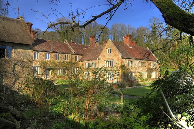
Mappercombe Manor House
Stately homes · 1.2 km

Mappercombe Manor
Castles · 1.2 km

Spring Hill
Mountains & hills · 1.9 km

Way's Hill
Mountains & hills · 2.0 km

Burcomb Wood
Literary houses · 2.7 km
Hillfort N of Burcombe Wood
Vineyards · 2.7 km

Mangerton Hill
Mountains & hills · 2.7 km

Drakenorth
Mountains & hills · 2.7 km

Mangerton Mill
Natural landmarks · 2.8 km
Nearby
📷 5Forts · South West England
Obelisk 10 Metres East Of Parish Church (Burts Of Mappercombe)
Obelisk 10 Metres East Of Parish Church (Burts Of Mappercombe) — a martello broad in england-south-west, United Kingdom.
📷 5Castles · South West England
Powerstock
Powerstock — a castle in england-south-west, United Kingdom.
📷 5Literary houses · South West England
Powerstock Castle
Powerstock Castle — a literary house museum in england south west.
Flagship📷 5Stately homes · South West England
Mappercombe Manor House
Mappercombe Manor House — Grade I listed manor house in Powerstock, Dorset, England, UK.
📷 5📷 5Mountains & hills · South West England
Spring Hill
Spring Hill — a hill or mountain in england south west.
Where to eat & stay near Parish Church of St Mary, Powerstock
Places to stay
 📷 5
📷 5Hotels · South West England
Hooke Court
Hooke Court — a hotel in england south west.
 📷 5
📷 5Campsites · South West England
Greenacres Campsite.
Greenacres Campsite. — a campsite in england south west.
 📷 5
📷 5Hotels · South West England
The Bull Hotel
The Bull Hotel — a hotel in england south west.
📷 5Caravan parks · South West England
Washingpool Caravan Site
Washingpool Caravan Site — a caravan park in england south west.
 📷 5
📷 5Caravan parks · South West England
Bide Yer
Bide Yer — a caravan park in england south west.
 📷 5
📷 5Campsites · South West England
Graston Farm Campsite
Graston Farm Campsite — a campsite in england south west.
Places to eat & drink
 📷 5
📷 5Historic pubs · South West England
Loders Arms Inn
Loders Arms Inn in England South West, United Kingdom.
 📷 5
📷 5Historic pubs · South West England
Pymore Inn
Pymore Inn in England South West, United Kingdom.
 📷 7
📷 7Historic pubs · South West England
Three Mariners Public House
Three Mariners Public House in England South West, United Kingdom.
 📷 5
📷 5Historic pubs · South West England
The Tiger Public House
The Tiger Public House in England South West, United Kingdom.
 📷 5
📷 5Historic pubs · South West England
10 North Street
10 North Street in England South West, United Kingdom.
 📷 7
📷 7Historic pubs · South West England
Greyhound Hotel
Greyhound Hotel in England South West, United Kingdom.
More places in this region
 📷 5
📷 5Historic churches · South West England
Abbey Church of St Gregory the Great, Downside Abbey
Abbey Church of St Gregory the Great, Downside Abbey — church in Stratton-on-the-Fosse, Somerset, England, UK.
 📷 5
📷 5Historic churches · South West England
All Saints Church
All Saints Church — Grade I listed church in Woolley, Somerset, England, UK.
 📷 5
📷 5Historic churches · South West England
All Saints Church, Hampreston
All Saints Church, Hampreston — church in Hampreston, Dorset, England, UK.
 📷 5
📷 5Historic churches · South West England
All Saints Church, Nether Cerne
All Saints Church, Nether Cerne — church in Nether Cerne, Dorset, England, UK.
Frequently asked questions
- Where is Parish Church of St Mary, Powerstock?
- Parish Church of St Mary, Powerstock is in South-West England, United Kingdom (postcode DT6 3TD), in the parish of Powerstock.
- What is Parish Church of St Mary, Powerstock?
- Parish Church of St Mary, Powerstock — Grade I listed building-listed church in england-south-west, United Kingdom.
- How do I get to Parish Church of St Mary, Powerstock?
- The nearest railway station is Maiden Newton, about 8.4 km away. The nearest town is Melplash. Drivers can use postcode DT6 3TD.
- When was Parish Church of St Mary, Powerstock built?
- Built or established in 1150.
- Is Parish Church of St Mary, Powerstock a listed building?
- Parish Church of St Mary, Powerstock is officially recognised as Grade I listed building listed.
- Is Parish Church of St Mary, Powerstock a protected site?
- Yes — Parish Church of St Mary, Powerstock is part of the Dorset National Landscape (AONB).
- Is Parish Church of St Mary, Powerstock free to visit?
- Yes, Parish Church of St Mary, Powerstock is free to enter.
- How do I get to Parish Church of St Mary, Powerstock?
- Drivers can navigate to postcode DT6 3TD. It sits within the West Dorset parliamentary constituency.