
Memorials & monuments · Yorkshire & the Humber
Old Tower
In or near Addingham.
Old Tower — Grade II listed building-listed memorial in england-yorkshire, United Kingdom.

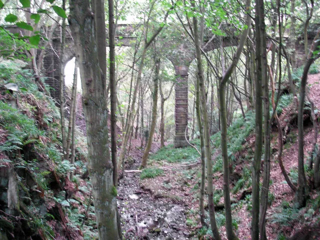
Kevin Waterhouse — CC BY-SA 2.0 via Wikimedia Commons licence

Plan your visit
- Typical visit
- 15 min–45 min
- Nearest railway station
- Steeton and Silsden · 4.0 km
- Free entry
- Dog-friendly
Getting there & planning your visit
To visit the Old Tower, the nearest railway station is Steeton and Silsden, located 4 km away. The postcode for sat-nav is BD20 0FW, and entry to the site is free.
About
Old Tower is a Grade II listed building-listed memorial in england-yorkshire, United Kingdom, registered on the National Heritage List for England (NHLE entry 1223448). Listed status protects buildings and structures of special architectural or historic interest. See the linked Wikipedia article for further details.
Photo gallery
Heritage listing
The Old Water Tower is an architectural monument of Mariupol in Ukraine. It is located in the central district at Architect Nilsen Street 36 (Ukrainian: вул. Архітектора Нільсена), at the intersection of Soborna Street and Enhel'sa St near Theatre Square. The tower was designed by architect Victor Nilsen and was completed in 1910. Built of red brick, it features various architectural styles. The tower is 33 metres tall with a spiral stair case of 157 steps.
From the Historic England List Entry under OGL v3.
Protected designations
- Area of Outstanding Natural Beauty: Nidderdale
Designations sourced from Natural England open data under OGL v3.
From the Wikipedia article
The Old Water Tower is an architectural monument of Mariupol in Ukraine. It is located in the central district at Architect Nilsen Street 36 (Ukrainian: вул. Архітектора Нільсена), at the intersection of Soborna Street and Enhel'sa St near Theatre Square. The tower was designed by architect Victor Nilsen and was completed in 1910. Built of red brick, it features various architectural styles. The tower is 33 metres tall with a spiral stair case of 157 steps. Located on the highest point in the area, it was not only the tallest structure at the time, but stood out as well.
Excerpt from Wikipedia under CC BY-SA 4.0. See the source article linked in Sources below.
Background
History
In 1906, there was no water supply in Mariupol and water carriers delivered water in barrels for a fee from a source of drinking water on Malofontannaya Street to the homes of local residents. On May 24, 1906, the Mariupol Duma (city council) adopted the proposal to secure a loan to finance the project of constructing a water supply network in Mariupol. The cost of its implementation was estimated at 360 thousand Rubles, which exceeded the city budget by far. Permission for obtaining a loan was granted by , Chairman of the Council of Ministers and concurrently Minister of the Internal Affairs of the Russian Empire, and the Mayor was informed of it in February 1907. Construction work on the…
Architecture
The tower was designed following eclecticism, a trend in architecture of the second half of the 19th century, in that it combines elements of various styles, here: Gothic, Renaissance and Baroque. Romanesque style is said to be found in the semicircular completion of arches and decorating details. Each of the red-and-white brick faces of the octahedral four-tier tower ends with a roof slope at the foot of a circular glazed viewing platform under an eight-slope roof. The walls of the structure are divided into three parts (first, second-third and fourth floors) by white-brick cornice masonry around the perimeter. The second and third floors are visually perceived as a single floor due to the…
Sourced from Wikipedia under CC BY-SA 4.0.
- Coordinates
- 53.9342, -1.9262
- District
- Bradford
- Parish
- Silsden
- Postcode
- BD20 0FW
- Parliamentary constituency
- Keighley and Ilkley
- Nearest railway station
- Steeton and Silsden — 4 km
Sources
- wikidata: Q26517716 (CC0)
- wikipedia: Old Tower, Mariupol (CC BY-SA 4.0)
Other places nearby

Cringles Park Home estate
Caravan parks · 0.3 km
Brook's Hill
Mountains & hills · 0.4 km

Potters Pits
Historic houses · 0.9 km

Brown Bank Caravan Park
Caravan parks · 1.4 km
Brown Bank
Mountains & hills · 1.4 km

Bank End
Archaeological sites · 1.5 km

Counter Hill Ironage camp
Archaeological sites · 1.6 km

Turner Lane T.P.
Archaeological sites · 1.6 km

Cote Close
Archaeological sites · 2.0 km

Lower Heights Farm
Caravan parks · 2.1 km

Barden Aqueduct
Historic bridges · 2.1 km
Barden Aqueduct
Aqueducts · 2.2 km
Nearby
📷 5Caravan parks · Yorkshire & the Humber
Cringles Park Home estate
Cringles Park Home estate — a caravan park in england yorkshire.
📷 5Mountains & hills · Yorkshire & the Humber
Brook's Hill
Brook's Hill — mountain in england yorkshire. Elevation: 875 ft m.
📷 3Historic houses · Yorkshire & the Humber
Potters Pits
Potters Pits — a historic house in england-yorkshire, United Kingdom.
📷 5Caravan parks · Yorkshire & the Humber
Brown Bank Caravan Park
Brown Bank Caravan Park — a caravan park in england yorkshire.
📷 5Mountains & hills · Yorkshire & the Humber
Brown Bank
Brown Bank — mountain in england yorkshire. Elevation: 259 m.
📷 3Archaeological sites · Yorkshire & the Humber
Bank End
Bank End — a archaeological in england-yorkshire, United Kingdom.
Where to eat & stay near Old Tower
Places to stay
📷 5Caravan parks · Yorkshire & the Humber
Cringles Park Home estate
Cringles Park Home estate — a caravan park in england yorkshire.
📷 5Caravan parks · Yorkshire & the Humber
Brown Bank Caravan Park
Brown Bank Caravan Park — a caravan park in england yorkshire.
📷 5Caravan parks · Yorkshire & the Humber
Lower Heights Farm
Lower Heights Farm — a caravan park in england yorkshire.
 📷 5
📷 5Caravan parks · Yorkshire & the Humber
School Wood Farm Holiday Home Park
School Wood Farm Holiday Home Park — a caravan park in england yorkshire.
 📷 5
📷 5Campsites · Yorkshire & the Humber
Draugton Heights
Draugton Heights — a campsite in england yorkshire.
 📷 5
📷 5Caravan parks · Yorkshire & the Humber
Olicana Caravan Park
Olicana Caravan Park — a caravan park in england yorkshire.
Places to eat & drink
 📷 5
📷 5Historic pubs · Yorkshire & the Humber
Elm Tree Inn
Elm Tree Inn in England Yorkshire, United Kingdom.
 📷 5
📷 5Historic pubs · Yorkshire & the Humber
The Devonshire
The Devonshire in England North West, United Kingdom.
 📷 5
📷 5Historic pubs · Yorkshire & the Humber
The Rustic Shop And Former Stable Buildings To Rear Of The Red Lion Public House
The Rustic Shop And Former Stable Buildings To Rear Of The Red Lion Public House in England North West, United Kingdom.
 📷 5
📷 5Restaurants · Yorkshire & the Humber
The Box Tree
The Box Tree — a restaurant in england yorkshire.
 📷 6
📷 6Historic pubs · Yorkshire & the Humber
Royal Shepherd Public House
Royal Shepherd Public House in England North West, United Kingdom.
 📷 5
📷 5Cafés · Yorkshire & the Humber
White Wells
White Wells — a café in england yorkshire.
More memorials in this region
 📷 3
📷 3Memorials & monuments · Yorkshire & the Humber
Disley War Memorial
Disley War Memorial — War memorial, dating to 1920.
 📷 3
📷 3Memorials & monuments · Yorkshire & the Humber
Hyde war memorial
Hyde war memorial is a memorial in the United Kingdom.
 📷 3
📷 3Memorials & monuments · Yorkshire & the Humber
Audenshaw War Memorial
Audenshaw War Memorial — Grade II listed building-listed memorial in england-west-midlands, United Kingdom.
 📷 3
📷 3Memorials & monuments · Yorkshire & the Humber
War memorial to front of Church of St Paul
War memorial to front of Church of St Paul — Grade II listed building-listed memorial in england-west-midlands, United Kingdom.
Frequently asked questions
- Where is Old Tower?
- Old Tower is in Yorkshire, United Kingdom (postcode BD20 0FW), in the parish of Silsden.
- What is Old Tower?
- Old Tower — Grade II listed building-listed memorial in england-yorkshire, United Kingdom.
- How do I get to Old Tower?
- The nearest railway station is Steeton and Silsden, about 4.0 km away. Drivers can use postcode BD20 0FW.
- Who owns Old Tower?
- Old Tower is owned by | landlord =.
- Is Old Tower a listed building?
- Old Tower is officially recognised as Grade II listed building listed.
- Is Old Tower a protected site?
- Yes — Old Tower is part of the Nidderdale National Landscape (AONB).
- Is Old Tower free to visit?
- Yes, Old Tower is free to enter.
- How do I get to Old Tower?
- The nearest railway station is Steeton and Silsden, about 4.0 km away. Drivers can navigate to postcode BD20 0FW.