Mountains & hills · North West England
Old Man of Coniston
Old Man of Coniston — Named summit at 802.4 m.

Wikimedia Commons contributors — see linked file page for photographer and licence licence
Plan your visit
- Typical visit
- 3 h–8 h
- Best time of year
- Late spring – early autumn (May–Oct)
- Free entry
- Dog-friendly
About
Old Man of Coniston is a named summit in the United Kingdom. Wikidata describes it as: "Named summit at 802.4 m.". Coordinates: 54.3707°, -3.1214°.
Photo gallery
From the Wikipedia article
The Old Man of Coniston is a fell in the Furness Fells of the Lake District in Cumbria, England, and is the highest point (county top) of the historic county of Lancashire. It is at least 2,632.62 feet (802.42 m) high, and lies to the west of the village of Coniston and the lake, Coniston Water. The fell is sometimes known by the alternative name of Coniston Old Man, or simply The Old Man. The mountain is popular with tourists and fell-walkers with a number of well-marked paths to the summit. The mountain has also seen extensive copper and slate mining activity for eight hundred years, and the remains of abandoned mines and spoil tips are a significant feature of the north-east slopes.
Excerpt from Wikipedia under CC BY-SA 4.0. See the source article linked in Sources below.
- Coordinates
- 54.3707, -3.1214
- District
- Westmorland and Furness
- Parish
- Coniston
- Postcode
- LA21 8HX
- Parliamentary constituency
- Westmorland and Lonsdale
Sources
- osm: n5378256988 (ODbL)
- wikipedia: Old Man of Coniston (CC BY-SA 4.0)
- commons: Ascending the Old Man - geograph.org.uk - 5036739.jpg (CC BY-SA 4.0)
Other places nearby
Loading nearby places…
Nearby
 📷 3
📷 3Natural landmarks · North West England
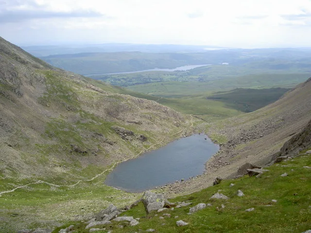
Goat's Water
Goat's Water — lake in the United Kingdom.
 📷 3
📷 3Mountains & hills · North West England
Brim Fell
Brim Fell — Named summit at 795.9 m.
 📷 3
📷 3Natural landmarks · North West England
Brim Fell
Brim Fell — mountain in United Kingdom.
Climbing & bouldering crags · North West England
Dow Crag
Dow Crag — a climbing crag in england north west.
 📷 3
📷 3Mountains & hills · North West England
Dow Crag
Dow Crag — Named summit at 778 m.
 📷 3
📷 3Natural landmarks · North West England
Dow Crag
Dow Crag — mountain in United Kingdom.
More mountains in this region
 📷 3
📷 3Mountains & hills · North West England
Allen Crags
Allen Crags — Named summit at 785 m.
 📷 3
📷 3Mountains & hills · North West England
Alum Pot
Alum Pot — Open shaft pothole in North Yorkshire.
 📷 3
📷 3Mountains & hills · North West England
Arnside Knott
Arnside Knott — Named summit at 159 m.
 📷 3
📷 3Mountains & hills · North West England
Aye Gill Pike
Aye Gill Pike — Named summit at 556.3 m.
Frequently asked questions
- Where is Old Man of Coniston?
- Old Man of Coniston is in North-West England, United Kingdom (postcode LA21 8HX), in the parish of Coniston.
- Is Old Man of Coniston free to visit?
- Yes, Old Man of Coniston is free to enter.
- How do I get to Old Man of Coniston?
- Drivers can navigate to postcode LA21 8HX. It sits within the Westmorland and Lonsdale parliamentary constituency.