Natural landmarks · North East England
Northumberland Sandstone Hills
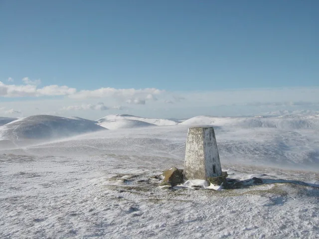
In or near Glanton.
Northumberland Sandstone Hills in England North East, United Kingdom.

Walter Baxter — CC BY-SA 2.0 via Wikimedia Commons licence
Plan your visit
- Typical visit
- 1 h–2 h
- Dog-friendly
About
Northumberland Sandstone Hills is a place of interest in England North East, United Kingdom — drawn from open-data sources for visitor reference. See the linked Wikipedia article for the full description.
Photo gallery
Protected designations
- Site of Special Scientific Interest: River Coquet and Coquet Valley Woodlands SSSI
- Site of Special Scientific Interest: Northumberland Shore SSSI
- Area of Outstanding Natural Beauty: Northumberland Coast
Designations sourced from Natural England open data under OGL v3.
From the Wikipedia article
The Northumberland Sandstone Hills are a major natural region in the English county of Northumberland. The hills form distinctive skylines with generally level tops, northwest facing scarps and craggy outcrops offering views to the Cheviots further west. The Northumberland Sandstone Hills lie not far from the coast of Northumberland and the region is listed as National Character Area no. 2 by Natural England, the UK Government's advisor on the natural environment. The region covers an area of 72,694 hectares (281 sq mi), beginning at Kyloe in the north and running in a strip roughly 10–15 kilometres (6–9 mi) wide and parallel to the coastal plain as far as Alnwick, where it changes direction to head southwest via Thrunton Wood, Rothbury Forest and Harwood Forest to the area of Throckington and the River Rede, passing over the highest peaks in the area, including Tosson Hill (1,444 feet (440 m)) in the Simonside Hills. The region has a range of semi-natural habitats: moorland with heather and rough, acid grassland mosaics on the thin, sandy soils of the higher steeper slopes and broken ground, transitioning through scrub, and oak or birch woodland to improved farmland and parkland on the lower slopes. Wet peaty flushes, mires, loughs and small reservoirs are dotted throughout the area and there are many caves, including St Cuthbert's Cave and Cateran Hole. Fifteen per cent of the NCA lies within the Northumberland National Park; it also contains one Special Protection Area – Holburn Lake & Moss – and three Special Areas of Conservation – Simonside Hills, Harbottle Moors, and River Tweed – as well as eighteen Sites of Special Scientific Interest, the SSIs totalling 3,771 hectares (14.6 sq mi). Its major watercourses are the rivers Aln, Till, Coquet, Font and Rede, and the Fallowlees Burn.
Excerpt from Wikipedia under CC BY-SA 4.0. See the source article linked in Sources below.
- Coordinates
- 55.4000, -1.8500
- District
- Northumberland
- Parish
- Whittingham
- Postcode
- NE66 4RT
- Parliamentary constituency
- North Northumberland
Sources
- wikidata: Q16896913 (CC0)
- wikipedia: Northumberland Sandstone Hills (CC BY-SA 4.0)
Other places nearby

Learchild Roman fort
Forts · 0.7 km

Whittingham Station
Heritage railway stations · 0.7 km

Bridge Of Aln Hotel
Historic pubs · 0.8 km

Bolton Bridge Over River Aln
Historic bridges · 1.9 km

statue of the 3rd Earl of Ravensworth
Memorials & monuments · 2.5 km
.jpg?width=1200)
Shawdon Hall
Historic houses · 2.5 km

Lemmington Hall
Historic houses · 2.6 km

Bridge Over River Aln
Historic bridges · 2.6 km
Whittingham
Other places · 2.7 km

Whittingham Tower And Attached Cottage
Memorials & monuments · 2.7 km

Fellbridge Monument
Memorials & monuments · 2.9 km

Whittingham War Memorial Cross
Memorials & monuments · 3.0 km
Nearby
📷 3📷 4Heritage railway stations · North East England
Whittingham Station
Whittingham Station in England North East, United Kingdom.
📷 7Historic pubs · North East England
Bridge Of Aln Hotel
Bridge Of Aln Hotel in Scotland Lowlands, United Kingdom.
📷 3Historic bridges · North East England
Bolton Bridge Over River Aln
Bolton Bridge Over River Aln — Grade II listed building-listed bridge in scotland-lowlands, United Kingdom.
📷 3Memorials & monuments · North East England
statue of the 3rd Earl of Ravensworth
statue of the 3rd Earl of Ravensworth is a memorial in the United Kingdom.
📷 3Historic houses · North East England
Shawdon Hall
Shawdon Hall — mansion in Hegeley parish, Northumberland, England, UK.
Where to eat & stay near Northumberland Sandstone Hills
Places to stay
 📷 5
📷 5 📷 5
📷 5Caravan parks · North East England
River Breamish - Caravan Club site
River Breamish - Caravan Club site — a caravan park in scotland lowlands.
 📷 5
📷 5Campsites · North East England
Powburn Scout Adventure Centre
Powburn Scout Adventure Centre — a campsite in scotland lowlands.
 📷 7
📷 7Hotels · North East England
The Cookie Jar
The Cookie Jar — a hotel in scotland lowlands.
 📷 5
📷 5 📷 5
📷 5Hotels · North East England
White Swan Hotel
White Swan Hotel in England North East, United Kingdom.
Places to eat & drink
📷 7Historic pubs · North East England
Bridge Of Aln Hotel
Bridge Of Aln Hotel in Scotland Lowlands, United Kingdom.
 📷 7
📷 7Historic pubs · North East England
Plough Inn With Outbuilding To North
Plough Inn With Outbuilding To North in Scotland Lowlands, United Kingdom.
 📷 7
📷 7Historic pubs · North East England
Black Swan Public House
Black Swan Public House in Scotland Lowlands, United Kingdom.
 📷 7
📷 7 📷 5
📷 5 📷 7
📷 7Historic pubs · North East England
Crown Public House
Crown Public House in Scotland Lowlands, United Kingdom.
More natural landmarks in this region
 📷 4
📷 4Natural landmarks · North East England
Cleveland Way
109-mile horseshoe trail around the North York Moors and its sea cliffs.
 📷 3
📷 3Natural landmarks · North East England
The Hand Stone
The Hand Stone — a other in england-yorkshire, United Kingdom.
 📷 3
📷 3Natural landmarks · North East England
The Face Stone
The Face Stone — a other in england-yorkshire, United Kingdom.
 📷 3
📷 3Frequently asked questions
- Where is Northumberland Sandstone Hills?
- Northumberland Sandstone Hills is in North-East England, United Kingdom (postcode NE66 4RT), in the parish of Whittingham.
- What is Northumberland Sandstone Hills?
- Northumberland Sandstone Hills in England North East, United Kingdom.
- How do I get to Northumberland Sandstone Hills?
- Drivers can use postcode NE66 4RT.
- Is Northumberland Sandstone Hills a protected site?
- Yes — Northumberland Sandstone Hills is part of the River Coquet and Coquet Valley Woodlands SSSI Site of Special Scientific Interest and the Northumberland Shore SSSI Site of Special Scientific Interest.
- How do I get to Northumberland Sandstone Hills?
- Drivers can navigate to postcode NE66 4RT. It sits within the North Northumberland parliamentary constituency.