Memorials & monuments · Mid Wales
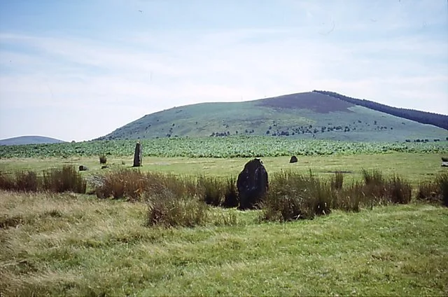
Mitchell's Fold
In or near Priestweston.
Mitchell's Fold in Wales Mid, United Kingdom.

Penny Mayes — CC BY-SA 2.0 via Wikimedia Commons licence
Plan your visit
- Typical visit
- 15 min–45 min
- Free entry
- Dog-friendly
About
Mitchell's Fold is a place of interest in Wales Mid, United Kingdom — drawn from open-data sources for visitor reference. See the linked Wikipedia article for the full description.
Photo gallery
Protected designations
- Area of Outstanding Natural Beauty: Shropshire Hills
Designations sourced from Natural England open data under OGL v3.
From the Wikipedia article
Mitchell's Fold (sometimes called Medgel's Fold or Madges Pinfold) is a Bronze Age stone circle in southwest Shropshire, located near the small village of White Grit on dry heathland at the southwest end of Stapeley Hill in the civil parish of Chirbury with Brompton, at a height of 353 metres (1,158 ft) AOD. The stone circle, a standing stone, and a cairn comprise a Scheduled Ancient Monument; the circle is in the guardianship of English Heritage.
Excerpt from Wikipedia under CC BY-SA 4.0. See the source article linked in Sources below.
Background
Description
above the Mitchells Fold stone circle]] As with most sites of this type, its true history is unknown. The name of the circle may derive from 'micel' or 'mycel', Old English for 'big', referring to the size of this large circle. Its doleritic stones came from nearby Stapeley Hill. Many of them are now missing and others are fallen. One example, reported in pagan magazine White Dragon, is that "This circle was the site of vandalism by a local farmer in the summer of 1995 when several stones were uprooted by a mechanical digger. The stones were promptly righted and "planted" again and the culprit punished. Ongoing unsympathetic use by both local youth and townie pagans, such as the creation of…
Sourced from Wikipedia under CC BY-SA 4.0.
- Coordinates
- 52.5787, -3.0261
- District
- Shropshire
- Parish
- Chirbury with Brompton
- Postcode
- SY5 0JH
- Parliamentary constituency
- South Shropshire
Sources
- wikidata: Q1939531 (CC0)
- wikipedia: Mitchell's Fold (CC BY-SA 4.0)
Other places nearby

Mitchell's Fold stone circle, standing stone and cairn 280m south west of Mitchell's Fold
Archaeological sites · 0.1 km

Stapeley Hill
Mountains & hills · 0.8 km

Whetstones
Hill forts · 0.9 km

River Onny
Natural landmarks · 1.2 km

Middleton-in-Chirbury War Memorial
Memorials & monuments · 1.3 km
Corndon Hill
Mountains & hills · 1.4 km

White Grit Enclosure, Priest Weston
Literary houses · 1.5 km

White Grit
Castles · 1.5 km
Lan Fawr
Mountains & hills · 1.8 km

Priestweston
Towns & cities · 1.8 km

Rorrington
Castles · 2.0 km
Motte castle adjacent to The Mount cottage
Literary houses · 2.1 km
Nearby
📷 3Archaeological sites · Mid Wales
Mitchell's Fold stone circle, standing stone and cairn 280m south west of Mitchell's Fold
Mitchell's Fold stone circle, standing stone and cairn 280m south west of Mitchell's Fold — archaeological site in Chirbury with Brompton, Shropshire, England, UK.
📷 4📷 3📷 4📷 3Memorials & monuments · Mid Wales
Middleton-in-Chirbury War Memorial
Middleton-in-Chirbury War Memorial — Grade II listed building-listed memorial in wales-mid, United Kingdom.
📷 3Where to eat & stay near Mitchell's Fold
Places to stay
 📷 5
📷 5Caravan parks · Mid Wales
Runnis Meadow Campsite
Runnis Meadow Campsite — a caravan park in wales mid.
 📷 5
📷 5 📷 5
📷 5Caravan parks · Mid Wales
Daisy Bank Touring Caravan Park
Daisy Bank Touring Caravan Park — a caravan park in wales mid.
 📷 5
📷 5 📷 5
📷 5 📷 5
📷 5Places to eat & drink
 📷 7
📷 7 📷 4
📷 4Historic pubs · Mid Wales
The Checkers
The Checkers in Wales Mid, United Kingdom.
 📷 5
📷 5Historic pubs · Mid Wales
The Black Lion And Forecourt Railings
The Black Lion And Forecourt Railings in Wales Mid, United Kingdom.
 📷 7
📷 7Historic pubs · Mid Wales
The Six Bells And Former Stables To Rear
The Six Bells And Former Stables To Rear in Wales Mid, United Kingdom.
 📷 7
📷 7 📷 5
📷 5More memorials in this region
 📷 5
📷 5Memorials & monuments · Mid Wales
Carreg Coetan Arthur
Carreg Coetan Arthur is a Neolithic dolmen in Newport, Pembrokeshire, Wales. Carreg Coetan Arthur dates from around 3000 BC and is the remains of a Neolithic burial chamber (also known as a quoit). Th
 📷 3
📷 3Memorials & monuments · Mid Wales
Dinas Island
Dinas Island (Welsh: Ynys Dinas) is a peninsula, partially detached from the mainland, in the community of Dinas Cross between Fishguard and Newport, Pembrokeshire, in southwest Wales. A triangulation
 📷 3
📷 3Memorials & monuments · Mid Wales
Rodney's Pillar
Rodney's Pillar is a memorial in the United Kingdom.
 📷 3
📷 3Memorials & monuments · Mid Wales
Alberbury War Memorial
Alberbury War Memorial — Grade II listed building-listed memorial in wales-north, United Kingdom.
Frequently asked questions
- Where is Mitchell's Fold?
- Mitchell's Fold is in Mid Wales, United Kingdom (postcode SY5 0JH), in the parish of Chirbury with Brompton.
- What is Mitchell's Fold?
- Mitchell's Fold in Wales Mid, United Kingdom.
- How do I get to Mitchell's Fold?
- Drivers can use postcode SY5 0JH.
- Who owns Mitchell's Fold?
- Mitchell's Fold is owned by English Heritage.
- Is Mitchell's Fold a protected site?
- Yes — Mitchell's Fold is part of the Shropshire Hills National Landscape (AONB).
- Is Mitchell's Fold free to visit?
- Yes, Mitchell's Fold is free to enter.
- How do I get to Mitchell's Fold?
- Drivers can navigate to postcode SY5 0JH. It sits within the South Shropshire parliamentary constituency.