
Archaeological sites · Mid Wales
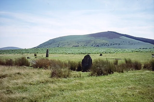
Mitchell's Fold stone circle, standing stone and cairn 280m south west of Mitchell's Fold
In or near Priestweston.
Mitchell's Fold stone circle, standing stone and cairn 280m south west of Mitchell's Fold — archaeological site in Chirbury with Brompton, Shropshire, England, UK.

Wikimedia Commons contributors — see linked file page for photographer and licence licence

Plan your visit
- Typical visit
- 45 min–1.5 h
- Free entry
- Dog-friendly
About
Mitchell's Fold stone circle, standing stone and cairn 280m south west of Mitchell's Fold is an archaeological site in the United Kingdom. Heritage designation: scheduled monument. Wikidata describes it as: "archaeological site in Chirbury with Brompton, Shropshire, England, UK". Coordinates: 52.5784°, -3.0281°.
Photo gallery
Protected designations
- Area of Outstanding Natural Beauty: Shropshire Hills
Designations sourced from Natural England open data under OGL v3.
Place summary
Mitchell's Fold stone circle, standing stone and cairn is located 280m south west of Mitchell's Fold in Mid Wales. This archaeological site is designated as a scheduled monument and lies within the Shropshire Hills Area of Outstanding Natural Beauty (AONB).
AI-generated from the structured facts on this page (operator, designation, listing, era). Not a substitute for visiting.
- Coordinates
- 52.5784, -3.0281
- District
- Powys
- Parish
- Churchstoke
- Postcode
- SY5 0JJ
- Parliamentary constituency
- Montgomeryshire and Glyndwr
Sources
- wikidata: Q17648734 (CC0)
- commons: Shropshire-MitchellsFoldStoneCircle.jpg (CC BY-SA 4.0)
Other places nearby

Mitchell's Fold
Memorials & monuments · 0.1 km

Whetstones
Hill forts · 0.8 km

Stapeley Hill
Mountains & hills · 0.9 km

River Onny
Natural landmarks · 1.1 km

Middleton-in-Chirbury War Memorial
Memorials & monuments · 1.2 km

White Grit Enclosure, Priest Weston
Literary houses · 1.4 km
Corndon Hill
Mountains & hills · 1.4 km

White Grit
Castles · 1.6 km

Priestweston
Towns & cities · 1.7 km
Lan Fawr
Mountains & hills · 1.7 km

Rorrington
Castles · 2.1 km
Motte castle adjacent to The Mount cottage
Literary houses · 2.1 km
Nearby
📷 5📷 3📷 4📷 4📷 3Memorials & monuments · Mid Wales
Middleton-in-Chirbury War Memorial
Middleton-in-Chirbury War Memorial — Grade II listed building-listed memorial in wales-mid, United Kingdom.
📷 5Literary houses · Mid Wales
White Grit Enclosure, Priest Weston
White Grit Enclosure, Priest Weston — a literary house museum in wales mid.
Where to eat & stay near Mitchell's Fold stone circle, standing stone and cairn 280m south west of Mitchell's Fold
Places to stay
 📷 5
📷 5Caravan parks · Mid Wales
Runnis Meadow Campsite
Runnis Meadow Campsite — a caravan park in wales mid.
 📷 5
📷 5 📷 5
📷 5Caravan parks · Mid Wales
Daisy Bank Touring Caravan Park
Daisy Bank Touring Caravan Park — a caravan park in wales mid.
 📷 5
📷 5 📷 5
📷 5 📷 5
📷 5Places to eat & drink
 📷 7
📷 7 📷 4
📷 4Historic pubs · Mid Wales
The Checkers
The Checkers in Wales Mid, United Kingdom.
 📷 5
📷 5Historic pubs · Mid Wales
The Black Lion And Forecourt Railings
The Black Lion And Forecourt Railings in Wales Mid, United Kingdom.
 📷 7
📷 7Historic pubs · Mid Wales
The Six Bells And Former Stables To Rear
The Six Bells And Former Stables To Rear in Wales Mid, United Kingdom.
 📷 7
📷 7 📷 5
📷 5More archaeological sites in this region
 📷 5
📷 5 📷 3
📷 3Archaeological sites · Mid Wales
Quaker settlement Dolgellau
Quaker settlement Dolgellau — a archaeological in wales-north, United Kingdom.
 📷 3
📷 3Archaeological sites · Mid Wales
Centenary Viewpoint
Centenary Viewpoint — a archaeological in wales-north, United Kingdom.
 📷 3
📷 3Archaeological sites · Mid Wales
Gwanas-Fawr Roman Marching Camp
Gwanas-Fawr Roman Marching Camp — a archaeological in wales-north, United Kingdom.
Frequently asked questions
- Where is Mitchell's Fold stone circle, standing stone and cairn 280m south west of Mitchell's Fold?
- Mitchell's Fold stone circle, standing stone and cairn 280m south west of Mitchell's Fold is in Mid Wales, United Kingdom (postcode SY5 0JJ), in the parish of Churchstoke.
- What is Mitchell's Fold stone circle, standing stone and cairn 280m south west of Mitchell's Fold?
- Mitchell's Fold stone circle, standing stone and cairn 280m south west of Mitchell's Fold — archaeological site in Chirbury with Brompton, Shropshire, England, UK.
- How do I get to Mitchell's Fold stone circle, standing stone and cairn 280m south west of Mitchell's Fold?
- Drivers can use postcode SY5 0JJ.
- Is Mitchell's Fold stone circle, standing stone and cairn 280m south west of Mitchell's Fold a listed building?
- Mitchell's Fold stone circle, standing stone and cairn 280m south west of Mitchell's Fold is officially recognised as scheduled monument listed.
- Is Mitchell's Fold stone circle, standing stone and cairn 280m south west of Mitchell's Fold a protected site?
- Yes — Mitchell's Fold stone circle, standing stone and cairn 280m south west of Mitchell's Fold is part of the Shropshire Hills National Landscape (AONB).
- Is Mitchell's Fold stone circle, standing stone and cairn 280m south west of Mitchell's Fold free to visit?
- Yes, Mitchell's Fold stone circle, standing stone and cairn 280m south west of Mitchell's Fold is free to enter.
- How do I get to Mitchell's Fold stone circle, standing stone and cairn 280m south west of Mitchell's Fold?
- Drivers can navigate to postcode SY5 0JJ. It sits within the Montgomeryshire and Glyndwr parliamentary constituency.