
Vineyards · East of England
Medieval settlement of Babingley
In or near Hillington.
human settlement in Sandringham, King's Lynn and West Norfolk, Norfolk, England, UK

Richard Humphrey — CC BY-SA 2.0 via Wikimedia Commons licence

Plan your visit
- Typical visit
- 1 h–2 h
- Best time of year
- Late summer & autumn (Aug–Oct)
- Nearest railway station
- King's Lynn · 7.7 km
About
Medieval settlement of Babingley is one of Britain's growing number of vineyards, located in england east midlands. UK viticulture has expanded significantly since the 1980s, with English sparkling wines now winning international awards. Most British vineyards offer tours and tastings of their estate-grown wines. human settlement in Sandringham, King's Lynn and West Norfolk, Norfolk, England, UK
Photo gallery
Protected designations
- Site of Special Scientific Interest: The Wash SSSI
- Area of Outstanding Natural Beauty: Norfolk Coast
- Ramsar wetland: The Wash
Designations sourced from Natural England open data under OGL v3.
Place summary
The Medieval settlement of Babingley is located in the East Midlands. This area features a vineyard, offering a setting for wine production among historical landscapes. Visitors can expect a tranquil environment that reflects the agricultural heritage of the region. The vineyard is part of the ongoing development of local viticulture, contributing to the area's economy and cultural identity.
AI-generated from the structured facts on this page (operator, designation, listing, era). Not a substitute for visiting.
- Coordinates
- 52.8068, 0.4767
- County
- Norfolk
- District
- King's Lynn and West Norfolk
- Parish
- Sandringham
- Postcode
- PE31 6AW
- Parliamentary constituency
- North West Norfolk
- Nearest railway station
- King's Lynn — 7.7 km
Sources
- wikidata: Q17671657 (CC0)
Other places nearby

Saint Felix
Historic houses · 0.4 km

Babingley Village Sign
Public art & sculpture · 0.6 km

Sandringham Estate
Caravan parks · 1.3 km

Lamp Post At Tf 6666 2473 Circa 20 Metres North Of Barn At Castle Farm
Memorials & monuments · 1.4 km

Lamp Post At Tf 6660 2473 Circa 50 Metres North West Of Barn At Castle Farm
Memorials & monuments · 1.4 km

Motte castle in Keeper's Wood, 670m east of Castle Rising Castle
Literary houses · 1.5 km
Castle Rising Keepers Wood
Literary houses · 1.5 km

Castle Rising
Castles · 1.6 km
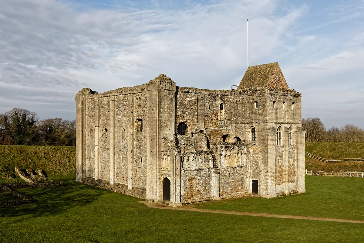
Castle Rising Castle
Castles · 1.6 km
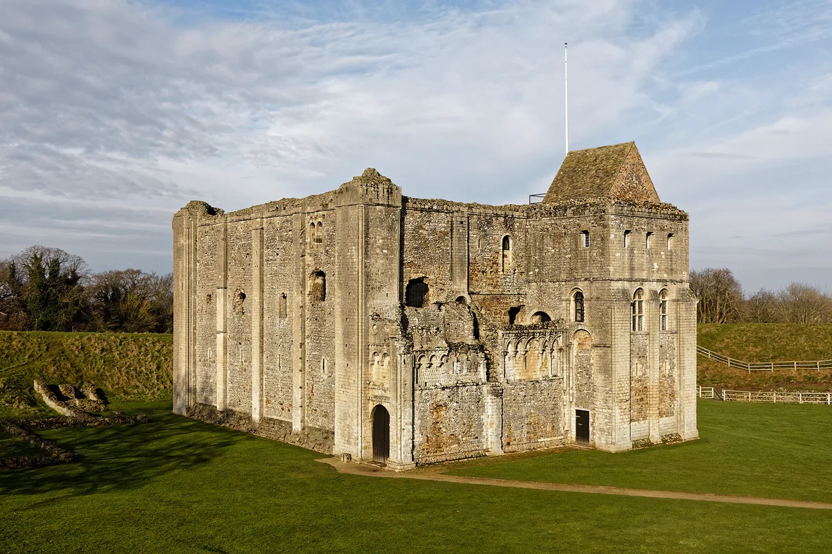
Ruins of castle and eleventh century church
Castles · 1.6 km

Sandringham Camping and Caravanning Club Site
Campsites · 1.8 km

Wolferton Village Sign
Public art & sculpture · 2.5 km
Nearby
📷 3Historic houses · East of England
Saint Felix
Saint Felix — a historic house in england-east-midlands, United Kingdom.
📷 3Public art & sculpture · East of England
Babingley Village Sign
Babingley Village Sign — a public art in england-east-midlands, United Kingdom.
📷 5Caravan parks · East of England
Sandringham Estate
Sandringham Estate — a caravan park in england east midlands.
📷 3Memorials & monuments · East of England
Lamp Post At Tf 6666 2473 Circa 20 Metres North Of Barn At Castle Farm
Lamp Post At Tf 6666 2473 Circa 20 Metres North Of Barn At Castle Farm — Grade II listed building-listed memorial in england-east-midlands, United Kingdom.
📷 3Memorials & monuments · East of England
Lamp Post At Tf 6660 2473 Circa 50 Metres North West Of Barn At Castle Farm
Lamp Post At Tf 6660 2473 Circa 50 Metres North West Of Barn At Castle Farm — Grade II listed building-listed memorial in england-east-midlands, United Kingdom.
📷 5Literary houses · East of England
Motte castle in Keeper's Wood, 670m east of Castle Rising Castle
motte-and-bailey castle in Castle Rising, King's Lynn and West Norfolk, England, UK
Where to eat & stay near Medieval settlement of Babingley
Places to stay
📷 5Caravan parks · East of England
Sandringham Estate
Sandringham Estate — a caravan park in england east midlands.
📷 5Campsites · East of England
Sandringham Camping and Caravanning Club Site
Sandringham Camping and Caravanning Club Site — a campsite in england east midlands.
 📷 5
📷 5Caravan parks · East of England
Gatton Waters
Gatton Waters — a caravan park in england east midlands.
 📷 5
📷 5Campsites · East of England
Four Oaks Camping
Four Oaks Camping — a campsite in england east midlands.
 📷 5
📷 5Campsites · East of England
Pine Cones Caravan & Camping
Pine Cones Caravan & Camping — a campsite in england east midlands.
 📷 5
📷 5Places to eat & drink
 📷 5
📷 5 📷 5
📷 5 📷 5
📷 5Historic pubs · East of England
Globe Hotel
Globe Hotel in England East, United Kingdom.
 📷 5
📷 5Historic pubs · East of England
Crown And Mitre Public House
Crown And Mitre Public House in England East, United Kingdom.
 📷 5
📷 5Historic pubs · East of England
The Hare Public House
The Hare Public House in England East, United Kingdom.
 📷 7
📷 7More places in this region
 📷 5
📷 5Vineyards · East of England
Chilford Hall Vineyard and Conference Centre
Chilford Hall Vineyard and Conference Centre — a vineyard in england-london, United Kingdom.
 📷 5
📷 5Vineyards · East of England
Verulamium, Prae Wood settlement
Verulamium, Prae Wood settlement — a UK vineyard in england london, producing English or Welsh wine from cool-climate grape varieties.
 📷 5
📷 5Vineyards · East of England
Ridgeon's Gardens, Castle Hill
Ridgeon's Gardens, Castle Hill — a UK vineyard in england london, producing English or Welsh wine from cool-climate grape varieties.
 📷 5
📷 5Vineyards · East of England
Marion's Close, Cambridge
Marion's Close, Cambridge — a UK vineyard in england london, producing English or Welsh wine from cool-climate grape varieties.
Frequently asked questions
- Where is Medieval settlement of Babingley?
- Medieval settlement of Babingley is in Norfolk, the East Midlands, United Kingdom (postcode PE31 6AW), in the parish of Sandringham.
- What is Medieval settlement of Babingley?
- human settlement in Sandringham, King's Lynn and West Norfolk, Norfolk, England, UK
- How do I get to Medieval settlement of Babingley?
- The nearest railway station is King's Lynn, about 7.7 km away. Drivers can use postcode PE31 6AW.
- Is Medieval settlement of Babingley a protected site?
- Yes — Medieval settlement of Babingley is part of the The Wash SSSI Site of Special Scientific Interest and the Norfolk Coast National Landscape (AONB).
- How do I get to Medieval settlement of Babingley?
- The nearest railway station is King's Lynn, about 7.7 km away. Drivers can navigate to postcode PE31 6AW.