Mountains & hills · Scottish Lowlands
Mathieside Cairn
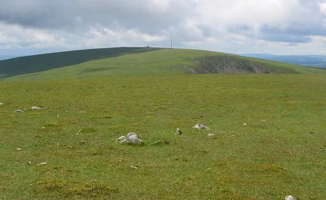
Mathieside Cairn — mountain in scotland lowlands. Elevation: 669 m.

Alan O'Dowd — CC BY-SA 2.0 via Wikimedia Commons licence
Plan your visit
- Typical visit
- 3 h–8 h
- Best time of year
- Late spring – early autumn (May–Oct)
About
Mathieside Cairn is a mountain located in scotland lowlands. Elevation: 669 m. A named British peak recorded in OpenStreetMap. Peaks are typically named on Ordnance Survey 1:50k mapping.
Photo gallery
Place summary
Mathieside Cairn is a mountain located in the Scottish Lowlands. This site features a prehistoric burial cairn, notable for its historical significance. The cairn is part of a larger landscape that reflects the area's ancient heritage and archaeological interest. Visitors can expect a rugged terrain typical of the region, offering a glimpse into Scotland's past.
AI-generated from the structured facts on this page (operator, designation, listing, era). Not a substitute for visiting.
- Coordinates
- 55.4858, -3.3786
Sources
- osm: n2695003386 (ODbL)
Other places nearby
Loading nearby places…
Nearby
📷 5Mountains & hills · Scottish Lowlands
Talla Cleuch Head
Talla Cleuch Head — a hill or mountain in scotland lowlands.
 📷 5
📷 5Mountains & hills · Scottish Lowlands
Talla Cleuch Head
Talla Cleuch Head — mountain in scotland lowlands.
 📷 5
📷 5Mountains & hills · Scottish Lowlands
Snout Hill
Snout Hill — mountain in scotland lowlands. Elevation: 511 m.
 📷 3
📷 3Reservoirs & lochs · Scottish Lowlands
Talla Reservoir
Talla Reservoir — artificial lake in Scottish Borders, Scotland, UK, on Talla Water.
 📷 3
📷 3Natural landmarks · Scottish Lowlands
Broad Law
Broad Law — 840m high mountain in Scottish Borders, Scotland, UK.
 📷 5
📷 5Mountains & hills · Scottish Lowlands
Garelet Hill
Garelet Hill — mountain in scotland lowlands. Elevation: 680 m.
Where to eat & stay near Mathieside Cairn
Places to stay
 📷 5
📷 5Campsites · Scottish Lowlands
Tibbie Shiels
Tibbie Shiels — a campsite in scotland lowlands.
 📷 5
📷 5B&Bs · Scottish Lowlands
Capperkirk
Capperkirk — a bed-and-breakfast in scotland lowlands.
 📷 5
📷 5Campsites · Central Scotland
Biggar Caravan Park
Biggar Caravan Park — a campsite in scotland central.
 📷 5
📷 5Caravan parks · Scottish Lowlands
Angecroft Caravan Park
Angecroft Caravan Park — a caravan park in scotland lowlands.
 📷 5
📷 5Hotels · Scottish Lowlands
Buccleuch Arms Hotel
Buccleuch Arms Hotel — a hotel in scotland lowlands.
 📷 5
📷 5Caravan parks · Scottish Lowlands
Honey Cottage Caravan Park
Honey Cottage Caravan Park — a caravan park in scotland lowlands.
Places to eat & drink
 📷 5
📷 5Historic pubs · Scottish Lowlands
Post Horn Hotel, Crawford
Post Horn Hotel, Crawford in Scotland Lowlands, United Kingdom.
 📷 5
📷 5Historic pubs · Central Scotland
The Bridge Inn, West Port, Peebles
The Bridge Inn, West Port, Peebles in Scotland Central, United Kingdom.
 📷 5
📷 5Historic pubs · Central Scotland
The Keg Lounge Bar, 11 High Street, Peebles
The Keg Lounge Bar, 11 High Street, Peebles in Scotland Central, United Kingdom.
 📷 5
📷 5Historic pubs · Central Scotland
Red Lion House, 36 Biggiesknowe, Peebles
Red Lion House, 36 Biggiesknowe, Peebles in Scotland Central, United Kingdom.
More mountains in this region
 📷 3
📷 3Mountains & hills · Scottish Lowlands
Andrewhinney Hill
Andrewhinney Hill — Named summit at 677 m.
 📷 3
📷 3Mountains & hills · Scottish Lowlands
Arbory Hill
Arbory Hill — Named summit at 429 m.
 📷 3
📷 3Mountains & hills · Scottish Lowlands
Auchenton Hill ( East Mount Lowther)
Auchenton Hill ( East Mount Lowther) — Named summit at 631 m.
 📷 3
📷 3Mountains & hills · Scottish Lowlands
Bakestall
Bakestall — Named summit at 673.5 m.
Frequently asked questions
- Where is Mathieside Cairn?
- Mathieside Cairn is in the Scottish Lowlands, United Kingdom.
- What is Mathieside Cairn?
- Mathieside Cairn — mountain in scotland lowlands. Elevation: 669 m.
- How do I get to Mathieside Cairn?
- Its coordinates are 55.4858°, -3.3786°.