
Natural landmarks · Scottish Lowlands
Broad Law
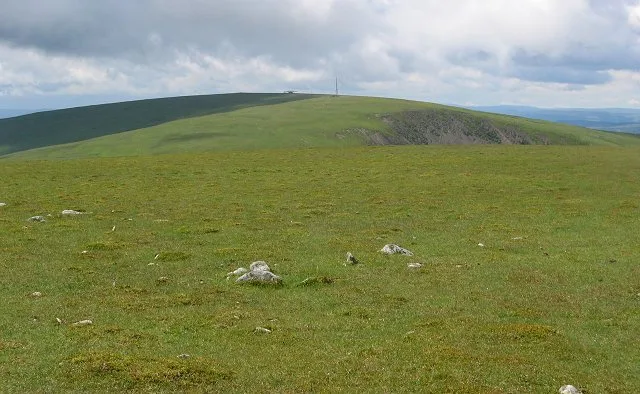
Broad Law — 840m high mountain in Scottish Borders, Scotland, UK.

Wikimedia Commons contributors — see linked file page for photographer and licence licence

Plan your visit
- Typical visit
- 1 h–2 h
- Free entry
- Dog-friendly
About
Broad Law is a named natural landmark in the United Kingdom. Wikidata describes it as: "840m high mountain in Scottish Borders, Scotland, UK". Coordinates: 55.4981°, -3.3527°.
Photo gallery
From the Wikipedia article
Broad Law is a hill in the Manor Hills range, part of the Southern Uplands of Scotland. The second-highest point in the Southern Uplands and the highest point in the Scottish Borders, it has an elevation of 840 metres, a prominence of 653 metres (and thus is a "major") and an isolation of 81 kilometres. It is only 3 m (10 ft) lower than its parent, Merrick. Like many of its neighbours it is smooth, rounded and grassy, although the surrounding glens have very steep sides — country somewhat akin to the Cheviots or the Howgill Fells. The hill is most easily climbed from the Megget Stane to the south, beginning at an elevation of 452 m (1,483 ft), but is also frequently climbed from the villages near its base, or as part of a long, 50 km (30 mi) trek across the local area between the towns of Peebles and Moffat. On the summit is the highest VOR beacon in the UK, and also a radio tower. The summit of Broad Law is also the highest point (county top) of the historic county of Peeblesshire. It is also sometimes (erroneously) given as the county top of Selkirkshire. This is because in 1891, the area of Megget (a detached part of Lyne parish in Peeblesshire) was transferred to Yarrow parish in Selkirkshire. The administrative "county" boundary of Peeblesshire and Selkirkshire thus temporarily crossed Broad Law summit between 1891 and 1974. However, the historic county boundary remained several kilometres to the east, where Dun Rig is the county top of Selkirkshire.
Excerpt from Wikipedia under CC BY-SA 4.0. See the source article linked in Sources below.
- Coordinates
- 55.4981, -3.3527
- Address
- Scottish Borders, Scotland
Sources
- wikidata: Q4971895 (CC0)
- wikipedia: Broad Law (CC BY-SA 4.0)
- commons: Cramalt Craig view to Broad Law.jpg (CC BY-SA 4.0)
Other places nearby
Broad Law
Mountains & hills · 0.0 km

Tods Knowe
Mountains & hills · 1.6 km

Snout Hill
Mountains & hills · 2.0 km

Mathieside Cairn
Mountains & hills · 2.1 km
Talla Cleuch Head
Mountains & hills · 2.1 km

Talla Cleuch Head
Mountains & hills · 2.2 km

Great Knock
Mountains & hills · 2.2 km

Lamb Knowe
Mountains & hills · 2.2 km

Cramalt Craig
Mountains & hills · 2.5 km
Cramalt Craig
Mountains & hills · 2.5 km

Pykestone Knowe
Mountains & hills · 2.9 km

Hunt Law
Mountains & hills · 2.9 km
Nearby
📷 3📷 5Mountains & hills · Scottish Lowlands
Tods Knowe
Tods Knowe — mountain in scotland lowlands. Elevation: 691 m.
📷 5Mountains & hills · Scottish Lowlands
Snout Hill
Snout Hill — mountain in scotland lowlands. Elevation: 511 m.
📷 5Mountains & hills · Scottish Lowlands
Mathieside Cairn
Mathieside Cairn — mountain in scotland lowlands. Elevation: 669 m.
📷 5Mountains & hills · Scottish Lowlands
Talla Cleuch Head
Talla Cleuch Head — a hill or mountain in scotland lowlands.
📷 5Mountains & hills · Scottish Lowlands
Talla Cleuch Head
Talla Cleuch Head — mountain in scotland lowlands.
Where to eat & stay near Broad Law
Places to stay
 📷 5
📷 5B&Bs · Scottish Lowlands
Capperkirk
Capperkirk — a bed-and-breakfast in scotland lowlands.
 📷 5
📷 5 📷 5
📷 5Caravan parks · Scottish Lowlands
Angecroft Caravan Park
Angecroft Caravan Park — a caravan park in scotland lowlands.
 📷 5
📷 5Caravan parks · Scottish Lowlands
Honey Cottage Caravan Park
Honey Cottage Caravan Park — a caravan park in scotland lowlands.
 📷 5
📷 5Campsites · Scottish Lowlands
Biggar Caravan Park
Biggar Caravan Park — a campsite in scotland central.
 📷 7
📷 7Hotels · Scottish Lowlands
The Elphinstone Hotel
The Elphinstone Hotel — a hotel in scotland central.
Places to eat & drink
 📷 7
📷 7Historic pubs · Scottish Lowlands
Post Horn Hotel, Crawford
Post Horn Hotel, Crawford in Scotland Lowlands, United Kingdom.
 📷 5
📷 5Historic pubs · Scottish Lowlands
The Bridge Inn, West Port, Peebles
The Bridge Inn, West Port, Peebles in Scotland Central, United Kingdom.
 📷 7
📷 7Historic pubs · Scottish Lowlands
The Keg Lounge Bar, 11 High Street, Peebles
The Keg Lounge Bar, 11 High Street, Peebles in Scotland Central, United Kingdom.
 📷 5
📷 5Historic pubs · Scottish Lowlands
Red Lion House, 36 Biggiesknowe, Peebles
Red Lion House, 36 Biggiesknowe, Peebles in Scotland Central, United Kingdom.
More natural landmarks in this region
 📷 5
📷 5Natural landmarks · Scottish Lowlands
Birkenside
Birkenside in England North East, United Kingdom.
 📷 4
📷 4Natural landmarks · Scottish Lowlands
River Teviot
River Teviot in England North East, United Kingdom.
 📷 5
📷 5Natural landmarks · Scottish Lowlands
River Leader
River Leader in England North East, United Kingdom.
 📷 4
📷 4Natural landmarks · Scottish Lowlands
Makerstoun
Makerstoun in England North East, United Kingdom.
Frequently asked questions
- Where is Broad Law?
- Broad Law is in the Scottish Lowlands, United Kingdom.
- What is Broad Law?
- Broad Law — 840m high mountain in Scottish Borders, Scotland, UK.
- How do I get to Broad Law?
- Its coordinates are 55.4981°, -3.3527°.
- Is Broad Law free to visit?
- Yes, Broad Law is free to enter.