Piers · East of England
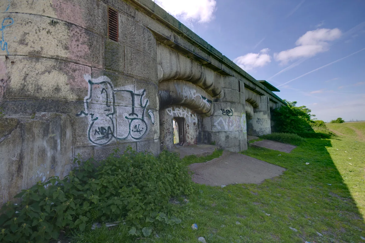
Marine Sand Unloading Pier
In or near Hoo St Werburgh.
Marine Sand Unloading Pier is a pier in the United Kingdom.

Robin Webster — CC BY-SA 2.0 via Wikimedia Commons licence
Plan your visit
- Typical visit
- 30 min–1 h
- Best time of year
- Summer
- Nearest railway station
- East Tilbury · 3.7 km
- Free entry
- Family-friendly
- Dog-friendly
- Limited wheelchair access
About
Marine Sand Unloading Pier is a seaside pier on the coast of London — Victorian pleasure architecture on stilts, still standing. The site is a designated Site of Special Scientific Interest, and is a Ramsar wetland of international importance. It sits within the South Basildon and East Thurrock parliamentary constituency. The nearest railway station is East Tilbury, about 3.7 km away. Postcode area RM18.
Photo gallery
360° viewimagery from 2025
Imagery © Mapillary contributors, CC BY-SA 4.0
Protected designations
- Site of Special Scientific Interest: South Thames Estuary and Marshes SSSI
- Site of Special Scientific Interest: Mucking Flats and Marshes SSSI
- Ramsar wetland: Thames Estuary & Marshes
Designations sourced from Natural England open data under OGL v3.
Place summary
The Marine Sand Unloading Pier is located in London, within the unparished area of Thurrock (postcode RM18). It is situated in a region designated as a Site of Special Scientific Interest (SSSI) for the South Thames Estuary and Marshes, as well as the Mucking Flats and Marshes. Additionally, it holds RAMSAR status, recognising its importance as a wetland habitat.
AI-generated from the structured facts on this page (operator, designation, listing, era). Not a substitute for visiting.
- Coordinates
- 51.4645, 0.4547
- District
- Thurrock
- Parish
- Thurrock, unparished area
- Postcode
- RM18 8QD
- Parliamentary constituency
- South Basildon and East Thurrock
- Nearest railway station
- East Tilbury — 3.7 km
Sources
- osm: w82102700 (ODbL)
Other places nearby

Cliffe Fort
Forts · 0.1 km

Hans Egede
Museums · 0.4 km

Flamingo Viewpoint
Viewpoints · 0.9 km

Coalhouse Fort
Museums · 1.5 km

Coalhouse Fort
Forts · 1.5 km

Radar Pool Viewpoint
Viewpoints · 1.7 km
East Tilbury
Museums · 1.8 km

Thames View Camping
Campsites · 1.9 km

The Pinnacle
Viewpoints · 1.9 km

Bata Cinema
Theatres · 2.1 km

Barrow Hill
Mountains & hills · 2.2 km
Shornemead Fort
Hill forts · 2.4 km
Nearby
📷 5📷 5📷 5Viewpoints · East of England
Flamingo Viewpoint
Flamingo Viewpoint — Named viewpoint at -4.440 m elevation.
📷 5Museums · East of England
Coalhouse Fort
Coalhouse Fort is an artillery fort in the eastern English county of Essex. It was built in the 1860s to guard the lower Thames from seaborne attack. It stands at Coalhouse Point on the north bank of
📷 5📷 5Viewpoints · East of England
Radar Pool Viewpoint
Radar Pool Viewpoint — Named viewpoint at -8.0452880859375 m elevation.
Where to eat & stay near Marine Sand Unloading Pier
Places to stay
📷 5Campsites · East of England
Thames View Camping
Thames View Camping — a campsite in england london.
 📷 5
📷 5Campsites · East of England
Condovers Scout Activity Centre
Condovers Scout Activity Centre — a campsite in england london.
 📷 5
📷 5 📷 5
📷 5 📷 5
📷 5B&Bs · South East England
Jessamine House
Jessamine House — a bed-and-breakfast in england london.
 📷 7
📷 7Places to eat & drink
 📷 7
📷 7Historic pubs · South East England
Sir John Falstaff Public House
Sir John Falstaff Public House in England South East, United Kingdom.
 📷 7
📷 7Historic pubs · South East England
Crown & Thistle
Crown & Thistle in England South East, United Kingdom.
 📷 7
📷 7Historic pubs · South East England
The Grapes Public House
The Grapes Public House in England South East, United Kingdom.
 📷 7
📷 7Historic pubs · South East England
The Three Daws Public House
The Three Daws Public House in England South East, United Kingdom.
 📷 5
📷 5Historic pubs · South East England
The Kent Public House
The Kent Public House in England South East, United Kingdom.
 📷 5
📷 5More piers in this region
 📷 5
📷 5 📷 5
📷 5 📷 5
📷 5 📷 5
📷 5Frequently asked questions
- Where is Marine Sand Unloading Pier?
- Marine Sand Unloading Pier is in London, United Kingdom (postcode RM18 8QD), in the parish of Thurrock, unparished area.
- What is Marine Sand Unloading Pier?
- Marine Sand Unloading Pier is a pier in the United Kingdom.
- How do I get to Marine Sand Unloading Pier?
- The nearest railway station is East Tilbury, about 3.7 km away. Drivers can use postcode RM18 8QD.
- Is Marine Sand Unloading Pier a protected site?
- Yes — Marine Sand Unloading Pier is part of the South Thames Estuary and Marshes SSSI Site of Special Scientific Interest and the Mucking Flats and Marshes SSSI Site of Special Scientific Interest.
- Is Marine Sand Unloading Pier free to visit?
- Yes, Marine Sand Unloading Pier is free to enter.
- How do I get to Marine Sand Unloading Pier?
- The nearest railway station is East Tilbury, about 3.7 km away. Drivers can navigate to postcode RM18 8QD.